![](/images/other/stat-length.png)
![Trail Walking Nice - Baie des anges Vieux Nice-St Jean Cap Ferrat - Photo](https://media.geolcdn.com/t/1900/400/ext.pjpeg?maxdim=2&url=https%3A%2F%2Fmedia.geolcdn.com%2Ff%2F30fb2590-b056-45d7-b68e-656f35a5b92f.jpg)
Baie des anges Vieux Nice-St Jean Cap Ferrat
coriace
User
![Length](/images/other/stat-length.png)
Length
20 km
![Max alt](https://static1.geolcdn.com/siteimages/upload/files/1508320355ic_sort_altitude_max_24dp.png)
Max alt
72 m
![Uphill gradient](https://static1.geolcdn.com/siteimages/upload/files/1508320355ic_sort_den_pos_24dp.png)
Uphill gradient
398 m
![Km-Effort](/images/other/stat-length.png)
Km-Effort
25 km
![Min alt](https://static1.geolcdn.com/siteimages/upload/files/1508320355ic_sort_altitude_min_24dp.png)
Min alt
-1 m
![Downhill gradient](https://static1.geolcdn.com/siteimages/upload/files/1508320355ic_sort_den_neg_24dp.png)
Downhill gradient
397 m
![Boucle](https://static1.geolcdn.com/siteimages/upload/files/16400158638029165_repeat_loop_refresh_sync_direction_icon.png)
Boucle
No
Creation date :
2020-02-20 06:51:47.007
Updated on :
2020-02-20 14:05:15.327
![Walking](https://static1.geolcdn.com/sitytour/trail-icons/101.png)
4h02
Difficulty : Medium
![Scan this QR Code to open this trail in the SityTrail application](https://capi.geolives.com/qq0zvz2zws4bq2lad0pu/sitytour/trails/2340592/qr.png?size=200)
FREE GPS app for hiking
About
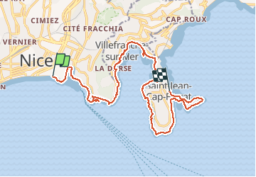
Trail Walking of 20 km to be discovered at Provence-Alpes-Côte d'Azur, Maritime Alps, Nice. This trail is proposed by coriace.
Description
Départ Vieux Nice face au Topaze vers St Jean Cap Ferrat par le sentier littoral.
2 voies sans issue à 3,6kms environ du départ et sur le parking gare de Beaulieu. Prendre les marches montantes sur la gauche.
Positioning
Country:
France
Region :
Provence-Alpes-Côte d'Azur
Department/Province :
Maritime Alps
Municipality :
Nice
Location:
Unknown
Start:(Dec)
Start:(UTM)
361143 ; 4839448 (32T) N.
Comments
Trails nearby
![Trail Walking Nice - Ballade chemin des douaniers Nice-Villefranche - Photo](https://media.geolcdn.com/t/375/260/ext.jpg?maxdim=2&url=https%3A%2F%2Fmedia.geolcdn.com%2Ff%2Fc2d5ab1c-da60-4999-9c1c-1e8798e5ba02.jpg)
![Walking Walking](https://static1.geolcdn.com/sitytour/trail-icons/101.png)
Ballade chemin des douaniers Nice-Villefranche
Walking
Very easy
(1)
Nice,
Provence-Alpes-Côte d'Azur,
Maritime Alps,
France
![](/images/other/stat-length.png)
7.9 km | 10.3 km-effort
2h 13min
![](https://static1.geolcdn.com/siteimages/upload/files/16400158638029165_repeat_loop_refresh_sync_direction_icon.png)
No
![Trail Walking Nice - Collines niçoises - Photo](https://media.geolcdn.com/t/375/260/ext.jpg?maxdim=2&url=https%3A%2F%2Fservices.sitytrail.com%2FGeolivesWS%2FDownloadMedia.ashx%3FTrailID%3D337283%26Media%3D20140820134937.jpg)
![Walking Walking](https://static1.geolcdn.com/sitytour/trail-icons/101.png)
Collines niçoises
Walking
Easy
(1)
Nice,
Provence-Alpes-Côte d'Azur,
Maritime Alps,
France
![](/images/other/stat-length.png)
21 km | 30 km-effort
6h 32min
![](https://static1.geolcdn.com/siteimages/upload/files/16400158638029165_repeat_loop_refresh_sync_direction_icon.png)
No
![Trail Walking Saint-Jean-Cap-Ferrat - Cap Ferrat 2011-10-27 - Photo](https://media.geolcdn.com/t/375/260/ext.jpg?maxdim=2&url=https%3A%2F%2Fservices.sitytrail.com%2FGeolivesWS%2FDownloadMedia.ashx%3FTrailID%3D89946%26Media%3D20111027142707.jpeg)
![Walking Walking](https://static1.geolcdn.com/sitytour/trail-icons/101.png)
Cap Ferrat 2011-10-27
Walking
Medium
(2)
Saint-Jean-Cap-Ferrat,
Provence-Alpes-Côte d'Azur,
Maritime Alps,
France
![](/images/other/stat-length.png)
10.9 km | 14 km-effort
4h 0min
![](https://static1.geolcdn.com/siteimages/upload/files/16400158638029165_repeat_loop_refresh_sync_direction_icon.png)
Yes
![Trail Walking Saint-Jean-Cap-Ferrat - w-frankrijk-tour-du-cap-ferrat - Photo](https://media.geolcdn.com/t/375/260/ext.jpg?maxdim=2&url=https%3A%2F%2Fstatic1.geolcdn.com%2Fsiteimages%2Fupload%2Ffiles%2F1553511878bg_sport_marche.png)
![Walking Walking](https://static1.geolcdn.com/sitytour/trail-icons/101.png)
w-frankrijk-tour-du-cap-ferrat
Walking
Very easy
(1)
Saint-Jean-Cap-Ferrat,
Provence-Alpes-Côte d'Azur,
Maritime Alps,
France
![](/images/other/stat-length.png)
6.5 km | 8.6 km-effort
Unknown
![](https://static1.geolcdn.com/siteimages/upload/files/16400158638029165_repeat_loop_refresh_sync_direction_icon.png)
No
![Trail Walking Saint-Jean-Cap-Ferrat - Tour du Cap Ferrat - Photo](https://media.geolcdn.com/t/375/260/ext.jpg?maxdim=2&url=https%3A%2F%2Fservices.sitytrail.com%2FGeolivesWS%2FDownloadMedia.ashx%3FTrailID%3D105209%26Media%3D8849_1.jpg)
![Walking Walking](https://static1.geolcdn.com/sitytour/trail-icons/101.png)
Tour du Cap Ferrat
Walking
Medium
(4)
Saint-Jean-Cap-Ferrat,
Provence-Alpes-Côte d'Azur,
Maritime Alps,
France
![](/images/other/stat-length.png)
8.9 km | 11.2 km-effort
2h 0min
![](https://static1.geolcdn.com/siteimages/upload/files/16400158638029165_repeat_loop_refresh_sync_direction_icon.png)
Yes
![Trail Walking Nice - Nice - Tour du Mont Boron - Photo](https://media.geolcdn.com/t/375/260/ext.jpg?maxdim=2&url=https%3A%2F%2Fmedia.geolcdn.com%2Ff%2Fbd67743c-530f-4072-b544-a2d6a051157c.jpg)
![Walking Walking](https://static1.geolcdn.com/sitytour/trail-icons/101.png)
Nice - Tour du Mont Boron
Walking
Easy
Nice,
Provence-Alpes-Côte d'Azur,
Maritime Alps,
France
![](/images/other/stat-length.png)
7.3 km | 10.5 km-effort
2h 48min
![](https://static1.geolcdn.com/siteimages/upload/files/16400158638029165_repeat_loop_refresh_sync_direction_icon.png)
Yes
![Trail Walking Nice - Balade Niçoise : Centre-Ville, Vieux-Nice, Le Port - Photo](https://media.geolcdn.com/t/375/260/ext.jpg?maxdim=2&url=https%3A%2F%2Fmedia.geolcdn.com%2Ff%2F5be08919-2063-4c5c-846d-f0957257afa5.jpg)
![Walking Walking](https://static1.geolcdn.com/sitytour/trail-icons/101.png)
Balade Niçoise : Centre-Ville, Vieux-Nice, Le Port
Walking
Very easy
Nice,
Provence-Alpes-Côte d'Azur,
Maritime Alps,
France
![](/images/other/stat-length.png)
5.4 km | 7.2 km-effort
2h 30min
![](https://static1.geolcdn.com/siteimages/upload/files/16400158638029165_repeat_loop_refresh_sync_direction_icon.png)
Yes
![Trail Walking Saint-Jean-Cap-Ferrat - Cap Ferrat - Photo](https://media.geolcdn.com/t/375/260/ext.jpg?maxdim=2&url=https%3A%2F%2Fmedia.geolcdn.com%2Ff%2Fc18b920e-7099-4709-86ec-e040cbd6631c.jpg)
![Walking Walking](https://static1.geolcdn.com/sitytour/trail-icons/101.png)
Cap Ferrat
Walking
Medium
Saint-Jean-Cap-Ferrat,
Provence-Alpes-Côte d'Azur,
Maritime Alps,
France
![](/images/other/stat-length.png)
8.2 km | 11 km-effort
3h 20min
![](https://static1.geolcdn.com/siteimages/upload/files/16400158638029165_repeat_loop_refresh_sync_direction_icon.png)
No
![Trail Walking Villefranche-sur-Mer - Tour_de_St_Jean_au_départ_des_Marinières-14087858-1641299736-752 - Photo](https://media.geolcdn.com/t/375/260/ext.jpg?maxdim=2&url=https%3A%2F%2Fstatic1.geolcdn.com%2Fsiteimages%2Fupload%2Ffiles%2F1553511878bg_sport_marche.png)
![Walking Walking](https://static1.geolcdn.com/sitytour/trail-icons/101.png)
Tour_de_St_Jean_au_départ_des_Marinières-14087858-1641299736-752
Walking
Easy
(1)
Villefranche-sur-Mer,
Provence-Alpes-Côte d'Azur,
Maritime Alps,
France
![](/images/other/stat-length.png)
12.3 km | 15.2 km-effort
3h 26min
![](https://static1.geolcdn.com/siteimages/upload/files/16400158638029165_repeat_loop_refresh_sync_direction_icon.png)
Yes