![](/images/other/stat-length.png)
![Trail Walking Vallées-d'Antraigues-Asperjoc - Antraigues sur Volane - Chateau de Craux - Photo](https://media.geolcdn.com/t/1900/400/ext.pjpeg?maxdim=2&url=https%3A%2F%2Fstatic1.geolcdn.com%2Fsiteimages%2Fupload%2Ffiles%2F1553511878bg_sport_marche.png)
Antraigues sur Volane - Chateau de Craux
mikaou.t
User
![Length](/images/other/stat-length.png)
Length
8 km
![Max alt](https://static1.geolcdn.com/siteimages/upload/files/1508320355ic_sort_altitude_max_24dp.png)
Max alt
674 m
![Uphill gradient](https://static1.geolcdn.com/siteimages/upload/files/1508320355ic_sort_den_pos_24dp.png)
Uphill gradient
291 m
![Km-Effort](/images/other/stat-length.png)
Km-Effort
11.9 km
![Min alt](https://static1.geolcdn.com/siteimages/upload/files/1508320355ic_sort_altitude_min_24dp.png)
Min alt
410 m
![Downhill gradient](https://static1.geolcdn.com/siteimages/upload/files/1508320355ic_sort_den_neg_24dp.png)
Downhill gradient
294 m
![Boucle](https://static1.geolcdn.com/siteimages/upload/files/16400158638029165_repeat_loop_refresh_sync_direction_icon.png)
Boucle
Yes
Creation date :
2020-02-20 09:23:38.939
Updated on :
2020-02-27 09:29:58.63
![Walking](https://static1.geolcdn.com/sitytour/trail-icons/101.png)
2h20
Difficulty : Medium
![Scan this QR Code to open this trail in the SityTrail application](https://capi.geolives.com/qq0zvz2zws4bq2lad0pu/sitytour/trails/2340460/qr.png?size=200)
FREE GPS app for hiking
About
Trail Walking of 8 km to be discovered at Auvergne-Rhône-Alpes, Ardèche, Vallées-d'Antraigues-Asperjoc. This trail is proposed by mikaou.t.
Description
Effectuer le circuit dans le sens indiqué (sens aiguilles d'une montre) afin de profiter pleinement des vues sur Antraigues à la descente.
Positioning
Country:
France
Region :
Auvergne-Rhône-Alpes
Department/Province :
Ardèche
Municipality :
Vallées-d'Antraigues-Asperjoc
Location:
Antraigues-sur-Volane
Start:(Dec)
Start:(UTM)
607778 ; 4952525 (31T) N.
Comments
Trails nearby
![Trail Walking Labastide-sur-Bésorgues - 2022-02-01_15h56m32_Les granges de Sausses 14,5km.GPX.xml - Photo](https://media.geolcdn.com/t/375/260/f7fbac7a-11f7-4ce8-b0bf-02f788ab9e07.jpg&format=jpg&maxdim=2)
![Walking Walking](https://static1.geolcdn.com/sitytour/trail-icons/101.png)
2022-02-01_15h56m32_Les granges de Sausses 14,5km.GPX.xml
Walking
Difficult
(1)
Labastide-sur-Bésorgues,
Auvergne-Rhône-Alpes,
Ardèche,
France
![](/images/other/stat-length.png)
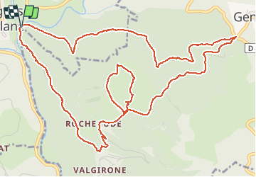
14.1 km | 24 km-effort
5h 37min
![](https://static1.geolcdn.com/siteimages/upload/files/16400158638029165_repeat_loop_refresh_sync_direction_icon.png)
Yes
![Trail Walking Vallées-d'Antraigues-Asperjoc - 07 antraigues - Photo](https://media.geolcdn.com/t/375/260/59713960-36e0-4cc2-a246-618043d58544.jpg&format=jpg&maxdim=2)
![Walking Walking](https://static1.geolcdn.com/sitytour/trail-icons/101.png)
07 antraigues
Walking
Difficult
Vallées-d'Antraigues-Asperjoc,
Auvergne-Rhône-Alpes,
Ardèche,
France
![](/images/other/stat-length.png)
14.4 km | 24 km-effort
7h 0min
![](https://static1.geolcdn.com/siteimages/upload/files/16400158638029165_repeat_loop_refresh_sync_direction_icon.png)
Yes
![Trail Walking Vallées-d'Antraigues-Asperjoc - Antraïgues 14km - Photo](https://media.geolcdn.com/t/375/260/ext.jpg?maxdim=2&url=https%3A%2F%2Fstatic1.geolcdn.com%2Fsiteimages%2Fupload%2Ffiles%2F1553511878bg_sport_marche.png)
![Walking Walking](https://static1.geolcdn.com/sitytour/trail-icons/101.png)
Antraïgues 14km
Walking
Medium
(1)
Vallées-d'Antraigues-Asperjoc,
Auvergne-Rhône-Alpes,
Ardèche,
France
![](/images/other/stat-length.png)
14.4 km | 22 km-effort
4h 56min
![](https://static1.geolcdn.com/siteimages/upload/files/16400158638029165_repeat_loop_refresh_sync_direction_icon.png)
Yes
![Trail Walking Saint-Joseph-des-Bancs - 07 st joseph les bancs - Photo](https://media.geolcdn.com/t/375/260/7e9021ed-61a8-43c1-8ba0-cf3b13c5f55b.jpg&format=jpg&maxdim=2)
![Walking Walking](https://static1.geolcdn.com/sitytour/trail-icons/101.png)
07 st joseph les bancs
Walking
Easy
Saint-Joseph-des-Bancs,
Auvergne-Rhône-Alpes,
Ardèche,
France
![](/images/other/stat-length.png)
18.4 km | 29 km-effort
7h 47min
![](https://static1.geolcdn.com/siteimages/upload/files/16400158638029165_repeat_loop_refresh_sync_direction_icon.png)
Yes
![Trail Walking Aizac - SityTrail - 2231069 - aizacxmal-combexla-bastide-sur-besorgue- - Photo](https://media.geolcdn.com/t/375/260/ext.jpg?maxdim=2&url=https%3A%2F%2Fstatic1.geolcdn.com%2Fsiteimages%2Fupload%2Ffiles%2F1553511878bg_sport_marche.png)
![Walking Walking](https://static1.geolcdn.com/sitytour/trail-icons/101.png)
SityTrail - 2231069 - aizacxmal-combexla-bastide-sur-besorgue-
Walking
Difficult
(1)
Aizac,
Auvergne-Rhône-Alpes,
Ardèche,
France
![](/images/other/stat-length.png)
10.3 km | 17.4 km-effort
3h 57min
![](https://static1.geolcdn.com/siteimages/upload/files/16400158638029165_repeat_loop_refresh_sync_direction_icon.png)
Yes
![Trail Walking Aizac - Aizac et la coupe d'Aizac - Photo](https://media.geolcdn.com/t/375/260/ext.jpg?maxdim=2&url=https%3A%2F%2Fstatic1.geolcdn.com%2Fsiteimages%2Fupload%2Ffiles%2F1553511878bg_sport_marche.png)
![Walking Walking](https://static1.geolcdn.com/sitytour/trail-icons/101.png)
Aizac et la coupe d'Aizac
Walking
Easy
(1)
Aizac,
Auvergne-Rhône-Alpes,
Ardèche,
France
![](/images/other/stat-length.png)
4.5 km | 7.5 km-effort
1h 24min
![](https://static1.geolcdn.com/siteimages/upload/files/16400158638029165_repeat_loop_refresh_sync_direction_icon.png)
Yes
![Trail Walking Saint-Andéol-de-Vals - 07 st Andeol de vals - Photo](https://media.geolcdn.com/t/375/260/a317618f-c6db-4fe3-a756-43f4ecdf49ea.jpg&format=jpg&maxdim=2)
![Walking Walking](https://static1.geolcdn.com/sitytour/trail-icons/101.png)
07 st Andeol de vals
Walking
Easy
Saint-Andéol-de-Vals,
Auvergne-Rhône-Alpes,
Ardèche,
France
![](/images/other/stat-length.png)
15.3 km | 24 km-effort
6h 3min
![](https://static1.geolcdn.com/siteimages/upload/files/16400158638029165_repeat_loop_refresh_sync_direction_icon.png)
Yes
![Trail Walking Vallées-d'Antraigues-Asperjoc - 07_antraigues_7km400m - Photo](https://media.geolcdn.com/t/375/260/465c52aa-adc5-4c16-841e-26a118bc0cec.jpg&format=jpg&maxdim=2)
![Walking Walking](https://static1.geolcdn.com/sitytour/trail-icons/101.png)
07_antraigues_7km400m
Walking
Easy
Vallées-d'Antraigues-Asperjoc,
Auvergne-Rhône-Alpes,
Ardèche,
France
![](/images/other/stat-length.png)
8.6 km | 13.2 km-effort
3h 7min
![](https://static1.geolcdn.com/siteimages/upload/files/16400158638029165_repeat_loop_refresh_sync_direction_icon.png)
Yes
![Trail Walking Vallées-d'Antraigues-Asperjoc - attribués sur volane - Photo](https://media.geolcdn.com/t/375/260/66f09833-ed62-4afc-bf56-380f58350a41.jpg&format=jpg&maxdim=2)
![Walking Walking](https://static1.geolcdn.com/sitytour/trail-icons/101.png)
attribués sur volane
Walking
Easy
Vallées-d'Antraigues-Asperjoc,
Auvergne-Rhône-Alpes,
Ardèche,
France
![](/images/other/stat-length.png)
9.1 km | 13.8 km-effort
5h 25min
![](https://static1.geolcdn.com/siteimages/upload/files/16400158638029165_repeat_loop_refresh_sync_direction_icon.png)
No