![](/images/other/stat-length.png)
![Trail Walking Nances - MONTAGNE DE L'EPINE: COTES DE NANCES - Photo](https://media.geolcdn.com/t/1900/400/c3dee223-efc2-4a59-9795-9717356e4c79.jpg&format=pjpeg&maxdim=2)
MONTAGNE DE L'EPINE: COTES DE NANCES
djeepee74
User
![Length](/images/other/stat-length.png)
![Max alt](https://static1.geolcdn.com/siteimages/upload/files/1508320355ic_sort_altitude_max_24dp.png)
![Uphill gradient](https://static1.geolcdn.com/siteimages/upload/files/1508320355ic_sort_den_pos_24dp.png)
![Km-Effort](/images/other/stat-length.png)
![Min alt](https://static1.geolcdn.com/siteimages/upload/files/1508320355ic_sort_altitude_min_24dp.png)
![Downhill gradient](https://static1.geolcdn.com/siteimages/upload/files/1508320355ic_sort_den_neg_24dp.png)
![Boucle](https://static1.geolcdn.com/siteimages/upload/files/16400158638029165_repeat_loop_refresh_sync_direction_icon.png)
![Walking](https://static1.geolcdn.com/sitytour/trail-icons/101.png)
4h30
Difficulty : Difficult
![Scan this QR Code to open this trail in the SityTrail application](https://capi.geolives.com/qq0zvz2zws4bq2lad0pu/sitytour/trails/2338900/qr.png?size=200)
FREE GPS app for hiking
About
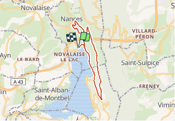
Trail Walking of 12.7 km to be discovered at Auvergne-Rhône-Alpes, Savoy, Nances. This trail is proposed by djeepee74.
Description
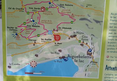
BOUCLE (enregistrement en live)... au départ du grand parking, situé sur la gauche à la sortie du péage de l'autoroute.
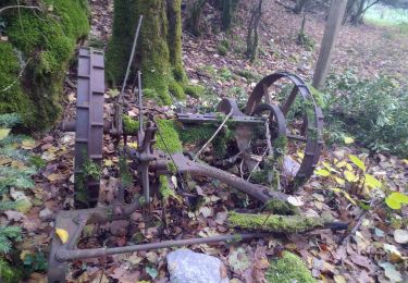
CURIOSITES: "Grotte du Loup" (Km 2.2) / "Grotte de la Conche" (Km 3)... sentier escarpé.
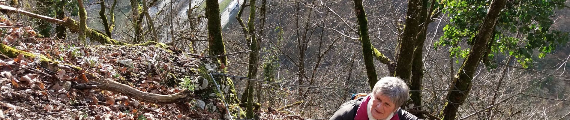
Du Km 3.2 en direction du "Reposoir" (jusqu'au Km 4)... en passant par "Les Balmes" (à la verticale du tunnel de l'Epine): Vous grimpez dans des barres rocheuses par un sentier escarpé et exposé, équipé de quelques câbles et protections... S'il vous prenait l'idée d'inverser le sens de la randonnée, il faut savoir que la descente de ces barres rocheuses peut impressionner des personnes non averties et/ou sujettes au vertige ou à la peur de vide.
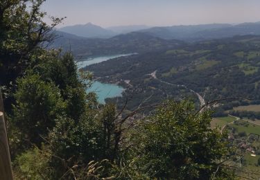
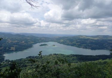
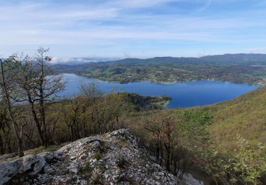
PANORAMA "Côtes de Nances" sur la Lac d'Aiguebelette (Km 5.5).
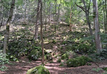
A partir du Km 6: Un large chemin fait place à un sentier pittoresque pentu, assez bien marqué dans l'ensemble.
Du Km 8.8 au Km 10: Sentier très gras.
Positioning
Comments
Trails nearby
![Trail Trail La Motte-Servolex - Château Richard et croix du Signal - Photo](https://media.geolcdn.com/t/375/260/3752241f-e62c-4bc8-86ee-aa981979bc96.jpg&format=jpg&maxdim=2)
![Trail Trail](https://static1.geolcdn.com/sitytour/trail-icons/104.png)
Trail
![](/images/other/stat-length.png)
![](https://static1.geolcdn.com/siteimages/upload/files/16400158638029165_repeat_loop_refresh_sync_direction_icon.png)
![Trail Walking Aiguebelette-le-Lac - Mont grêle - Photo](https://media.geolcdn.com/t/375/260/ext.jpg?maxdim=2&url=https%3A%2F%2Fstatic1.geolcdn.com%2Fsiteimages%2Fupload%2Ffiles%2F1553511878bg_sport_marche.png)
![Walking Walking](https://static1.geolcdn.com/sitytour/trail-icons/101.png)
Walking
![](/images/other/stat-length.png)
![](https://static1.geolcdn.com/siteimages/upload/files/16400158638029165_repeat_loop_refresh_sync_direction_icon.png)
![Trail Walking La Motte-Servolex - 73 Croix du signal via Château Renard - Photo](https://media.geolcdn.com/t/375/260/b1ac2841-4f6c-4818-af5e-d71b85094992.jpg&format=jpg&maxdim=2)
![Walking Walking](https://static1.geolcdn.com/sitytour/trail-icons/101.png)
Walking
![](/images/other/stat-length.png)
![](https://static1.geolcdn.com/siteimages/upload/files/16400158638029165_repeat_loop_refresh_sync_direction_icon.png)
![Trail Walking Aiguebelette-le-Lac - 73 aiguebelette zel - Photo](https://media.geolcdn.com/t/375/260/ab86e02e-83d8-47aa-9f9b-0d6ea22ba856.jpg&format=jpg&maxdim=2)
![Walking Walking](https://static1.geolcdn.com/sitytour/trail-icons/101.png)
Walking
![](/images/other/stat-length.png)
![](https://static1.geolcdn.com/siteimages/upload/files/16400158638029165_repeat_loop_refresh_sync_direction_icon.png)
![Trail Walking Aiguebelette-le-Lac - Montagne de l'Epine 2.6.24 - Photo](https://media.geolcdn.com/t/375/260/58f813b2-778e-45f5-aeaf-4a7a3dba23b4.jpg&format=jpg&maxdim=2)
![Walking Walking](https://static1.geolcdn.com/sitytour/trail-icons/101.png)
Walking
![](/images/other/stat-length.png)
![](https://static1.geolcdn.com/siteimages/upload/files/16400158638029165_repeat_loop_refresh_sync_direction_icon.png)
![Trail Walking Aiguebelette-le-Lac - Mont Grêle - Photo](https://media.geolcdn.com/t/375/260/4dc3a178-8cfd-47eb-bb85-9b4370a887ab.jpg&format=jpg&maxdim=2)
![Walking Walking](https://static1.geolcdn.com/sitytour/trail-icons/101.png)
Walking
![](/images/other/stat-length.png)
![](https://static1.geolcdn.com/siteimages/upload/files/16400158638029165_repeat_loop_refresh_sync_direction_icon.png)
![Trail Walking Saint-Sulpice - st Sulpice - croix de crucifix - Aiguebelette - Photo](https://media.geolcdn.com/t/375/260/6f4855e6-ef2a-4072-968f-26eff92ed454.jpg&format=jpg&maxdim=2)
![Walking Walking](https://static1.geolcdn.com/sitytour/trail-icons/101.png)
Walking
![](/images/other/stat-length.png)
![](https://static1.geolcdn.com/siteimages/upload/files/16400158638029165_repeat_loop_refresh_sync_direction_icon.png)
![Trail Walking Nances - ballade vers Nances - Photo](https://media.geolcdn.com/t/375/260/08823fc1-7084-40fb-98e3-3a7cfdd25397.jpg&format=jpg&maxdim=2)
![Walking Walking](https://static1.geolcdn.com/sitytour/trail-icons/101.png)
Walking
![](/images/other/stat-length.png)
![](https://static1.geolcdn.com/siteimages/upload/files/16400158638029165_repeat_loop_refresh_sync_direction_icon.png)
![Trail Walking Aiguebelette-le-Lac - Belvédère du Rocher du Corbeau - Photo](https://media.geolcdn.com/t/375/260/ce4a0898-93e9-4db9-96e7-643f23060884.jpg&format=jpg&maxdim=2)
![Walking Walking](https://static1.geolcdn.com/sitytour/trail-icons/101.png)
Walking
![](/images/other/stat-length.png)
![](https://static1.geolcdn.com/siteimages/upload/files/16400158638029165_repeat_loop_refresh_sync_direction_icon.png)