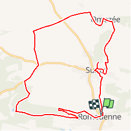
![](/images/other/stat-length.png)
![Trail Walking Philippeville - De Romedenne à Omezée par Surice - Photo](https://media.geolcdn.com/t/1900/400/ext.pjpeg?maxdim=2&url=https%3A%2F%2Fstatic1.geolcdn.com%2Fsiteimages%2Fupload%2Ffiles%2F1553511878bg_sport_marche.png)
De Romedenne à Omezée par Surice
pjjrevrard
User
![Length](/images/other/stat-length.png)
![Max alt](https://static1.geolcdn.com/siteimages/upload/files/1508320355ic_sort_altitude_max_24dp.png)
![Uphill gradient](https://static1.geolcdn.com/siteimages/upload/files/1508320355ic_sort_den_pos_24dp.png)
![Km-Effort](/images/other/stat-length.png)
![Min alt](https://static1.geolcdn.com/siteimages/upload/files/1508320355ic_sort_altitude_min_24dp.png)
![Downhill gradient](https://static1.geolcdn.com/siteimages/upload/files/1508320355ic_sort_den_neg_24dp.png)
![Boucle](https://static1.geolcdn.com/siteimages/upload/files/16400158638029165_repeat_loop_refresh_sync_direction_icon.png)
![Walking](https://static1.geolcdn.com/sitytour/trail-icons/101.png)
2h45
Difficulty : Easy
![Scan this QR Code to open this trail in the SityTrail application](https://capi.geolives.com/qq0zvz2zws4bq2lad0pu/sitytour/trails/233326/qr.png?size=200)
FREE GPS app for hiking
About
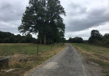
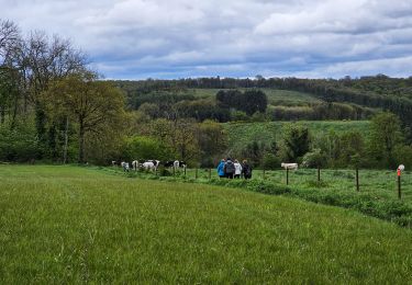
Trail Walking of 11 km to be discovered at Wallonia, Namur, Philippeville. This trail is proposed by pjjrevrard.
Description
© Desrumaux TraceGPS Le village eut à souffrir des guerres entre la France et l''Espagne et fut en grande partie détruit en 1914.
Romedenne fut détaché de la commune de Surice en 1901.
Le noyau ancien du village s''étire entre l''église et la fontaine St-Pierre mais s''est étendu dans la plaine jusqu''au chemin de fer désaffecté depuis 1971.
SURICE dépendait de la baronnie de Florennes et, comme beaucoup d''autres villages de la région, faisait donc partie de la principauté de Liège.
Le village eut à souffrir d''un horrible massacre lors de sa traversée par les troupes allemandes en 1914 qui détruisirent les trois quarts du village.
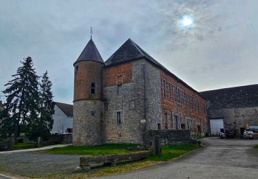
L''habitat se regroupe d''une part autour de l''église, du château et de sa ferme et d''autre part autour d''une place triangulaire herbeuse.
OMEZÉE est un minuscule village au sein de l’Entre-Sambre et Meuse, faisant partie de l’entité de Philippeville, Omezée était avant la fusion des communes la plus petite commune de Belgique avec une superficie de 393 ha. Aujourd’hui, 54 habitants résident dans la trentaine de maisons du village
Omezée possède trois tilleuls imposants. Marie-Thérèse, fille de Joseph II, les aurait fait planter. Le premier se trouve devant le porche de l’église. Le second se dresse entre le village et Champelle. Il supporte un Christ en croix. Le troisième se situe au bord du chemin de Soulme. Une niche renfermant Saint-Donat y est fixée.
L’église fut érigée quatre fois. Tout d’abord, une chapelle castrale correspondant à l’emplacement du chœur actuel. En 1695 apparaît la nef actuelle. Le porche d’entrée et son clocher s’ajoutent en 1786. En 1902, une sacristie vient compléter l’ensemble.
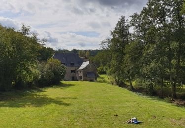
Départ : Église de Romedenne.
Détails sur TraceGPS.com
http://www.tracegps.com/fr/parcours/circuit9216.htm#
Positioning
Comments
Trails nearby
![Trail Walking Doische - RB-Na-11 La vallée de l’Hermeton - Photo](https://media.geolcdn.com/t/375/260/ext.jpg?maxdim=2&url=https%3A%2F%2Fservices.sitytrail.com%2FGeolivesWS%2FDownloadMedia.ashx%3FTrailID%3D179637%26Media%3D97aab1d2-a5d6-4980-8916-291d500d2803.jpg)
![Walking Walking](https://static1.geolcdn.com/sitytour/trail-icons/101.png)
Walking
![](/images/other/stat-length.png)
![](https://static1.geolcdn.com/siteimages/upload/files/16400158638029165_repeat_loop_refresh_sync_direction_icon.png)
![Trail Walking Philippeville - Balade a Franchimont - Photo](https://media.geolcdn.com/t/375/260/ext.jpg?maxdim=2&url=https%3A%2F%2Fservices.sitytrail.com%2FGeolivesWS%2FDownloadMedia.ashx%3FTrailID%3D1022738%26Media%3D20180815124535.jpg)
![Walking Walking](https://static1.geolcdn.com/sitytour/trail-icons/101.png)
Walking
![](/images/other/stat-length.png)
![](https://static1.geolcdn.com/siteimages/upload/files/16400158638029165_repeat_loop_refresh_sync_direction_icon.png)
![Trail Walking Doische - RB-Na-11 Raccourci - La vallée de l’Hermeton - Photo](https://media.geolcdn.com/t/375/260/ext.jpg?maxdim=2&url=https%3A%2F%2Fstatic1.geolcdn.com%2Fsiteimages%2Fupload%2Ffiles%2F1553511878bg_sport_marche.png)
![Walking Walking](https://static1.geolcdn.com/sitytour/trail-icons/101.png)
Walking
![](/images/other/stat-length.png)
![](https://static1.geolcdn.com/siteimages/upload/files/16400158638029165_repeat_loop_refresh_sync_direction_icon.png)
![Trail Walking Doische - De Gochenee vers Soulme par la vallee de l'Ermeton - Photo](https://media.geolcdn.com/t/375/260/ext.jpg?maxdim=2&url=https%3A%2F%2Fstatic1.geolcdn.com%2Fsiteimages%2Fupload%2Ffiles%2F1553511878bg_sport_marche.png)
![Walking Walking](https://static1.geolcdn.com/sitytour/trail-icons/101.png)
Walking
![](/images/other/stat-length.png)
![](https://static1.geolcdn.com/siteimages/upload/files/16400158638029165_repeat_loop_refresh_sync_direction_icon.png)
![Trail Walking Doische - Promenade à Vodelée - Photo](https://media.geolcdn.com/t/375/260/ext.jpg?maxdim=2&url=https%3A%2F%2Fstatic1.geolcdn.com%2Fsiteimages%2Fupload%2Ffiles%2F1553511878bg_sport_marche.png)
![Walking Walking](https://static1.geolcdn.com/sitytour/trail-icons/101.png)
Walking
![](/images/other/stat-length.png)
![](https://static1.geolcdn.com/siteimages/upload/files/16400158638029165_repeat_loop_refresh_sync_direction_icon.png)
![Trail Walking Philippeville - Balade à Omezée - Photo](https://media.geolcdn.com/t/375/260/d0f447be-f54e-441d-b772-99cec4ce701f.jpeg&format=jpg&maxdim=2)
![Walking Walking](https://static1.geolcdn.com/sitytour/trail-icons/101.png)
Walking
![](/images/other/stat-length.png)
![](https://static1.geolcdn.com/siteimages/upload/files/16400158638029165_repeat_loop_refresh_sync_direction_icon.png)
![Trail Walking Doische - Balade de Doische à Foisches - Photo](https://media.geolcdn.com/t/375/260/f8b30e3a-39db-421e-94ed-d41213e0167d.jpeg&format=jpg&maxdim=2)
![Walking Walking](https://static1.geolcdn.com/sitytour/trail-icons/101.png)
Walking
![](/images/other/stat-length.png)
![](https://static1.geolcdn.com/siteimages/upload/files/16400158638029165_repeat_loop_refresh_sync_direction_icon.png)
![Trail Walking Doische - La Boucle de l'Hermeton - Photo](https://media.geolcdn.com/t/375/260/c5cf3b26-e3a8-49a4-9696-0ff21384f9ea.jpg&format=jpg&maxdim=2)
![Walking Walking](https://static1.geolcdn.com/sitytour/trail-icons/101.png)
Walking
![](/images/other/stat-length.png)
![](https://static1.geolcdn.com/siteimages/upload/files/16400158638029165_repeat_loop_refresh_sync_direction_icon.png)
![Trail Walking Doische - Promenade de la Bonne-Fontaine - Photo](https://media.geolcdn.com/t/375/260/b9d49c14-e249-4d19-a8a1-50d5262ebbb9.jpg&format=jpg&maxdim=2)
![Walking Walking](https://static1.geolcdn.com/sitytour/trail-icons/101.png)
Walking
![](/images/other/stat-length.png)
![](https://static1.geolcdn.com/siteimages/upload/files/16400158638029165_repeat_loop_refresh_sync_direction_icon.png)