![](/images/other/stat-length.png)
![Trail Walking Saint-Jean-de-la-Blaquière - Saint Jean de la Blaquière (dolmen des Isserts, tombe protestante, saut du poisson, canyon du diable) - Photo](https://media.geolcdn.com/t/1900/400/ext.pjpeg?maxdim=2&url=https%3A%2F%2Fstatic1.geolcdn.com%2Fsiteimages%2Fupload%2Ffiles%2F1553511878bg_sport_marche.png)
Saint Jean de la Blaquière (dolmen des Isserts, tombe protestante, saut du poisson, canyon du diable)
coulombf
User
![Length](/images/other/stat-length.png)
Length
10.7 km
![Max alt](https://static1.geolcdn.com/siteimages/upload/files/1508320355ic_sort_altitude_max_24dp.png)
Max alt
199 m
![Uphill gradient](https://static1.geolcdn.com/siteimages/upload/files/1508320355ic_sort_den_pos_24dp.png)
Uphill gradient
218 m
![Km-Effort](/images/other/stat-length.png)
Km-Effort
13.6 km
![Min alt](https://static1.geolcdn.com/siteimages/upload/files/1508320355ic_sort_altitude_min_24dp.png)
Min alt
120 m
![Downhill gradient](https://static1.geolcdn.com/siteimages/upload/files/1508320355ic_sort_den_neg_24dp.png)
Downhill gradient
215 m
![Boucle](https://static1.geolcdn.com/siteimages/upload/files/16400158638029165_repeat_loop_refresh_sync_direction_icon.png)
Boucle
Yes
Creation date :
2020-02-12 08:42:40.0
Updated on :
2020-02-25 14:20:08.696
![Walking](https://static1.geolcdn.com/sitytour/trail-icons/101.png)
3h20
Difficulty : Easy
![Scan this QR Code to open this trail in the SityTrail application](https://capi.geolives.com/qq0zvz2zws4bq2lad0pu/sitytour/trails/2332184/qr.png?size=200)
FREE GPS app for hiking
About
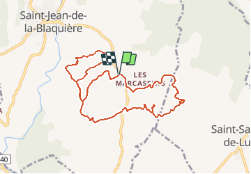
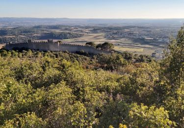
Trail Walking of 10.7 km to be discovered at Occitania, Hérault, Saint-Jean-de-la-Blaquière. This trail is proposed by coulombf.
Description
12/02/2020
Version longue (1/2 journée).
Reconnaissance avec Brigitte FLEURY, Odile BOISSELOT, Jacques et Nicole BRIVET, Serge VARENNE
Positioning
Country:
France
Region :
Occitania
Department/Province :
Hérault
Municipality :
Saint-Jean-de-la-Blaquière
Location:
Unknown
Start:(Dec)
Start:(UTM)
535479 ; 4839241 (31T) N.
Comments
Trails nearby
![Trail Walking Le Bosc - Saint-Alban - Célis - La Roque - Photo](https://media.geolcdn.com/t/375/260/932d7dea-57ce-4b8a-b586-1c6511489398.jpg&format=jpg&maxdim=2)
![Walking Walking](https://static1.geolcdn.com/sitytour/trail-icons/101.png)
Saint-Alban - Célis - La Roque
Walking
Medium
(1)
Le Bosc,
Occitania,
Hérault,
France
![](/images/other/stat-length.png)
5.7 km | 7.9 km-effort
1h 47min
![](https://static1.geolcdn.com/siteimages/upload/files/16400158638029165_repeat_loop_refresh_sync_direction_icon.png)
Yes
![Trail Walking Saint-Saturnin-de-Lucian - Le Rocher des vierges - Photo](https://media.geolcdn.com/t/375/260/ext.jpg?maxdim=2&url=https%3A%2F%2Fservices.sitytrail.com%2FGeolivesWS%2FDownloadMedia.ashx%3FTrailID%3D874639%26Media%3D20171212140026.jpg)
![Walking Walking](https://static1.geolcdn.com/sitytour/trail-icons/101.png)
Le Rocher des vierges
Walking
Medium
(2)
Saint-Saturnin-de-Lucian,
Occitania,
Hérault,
France
![](/images/other/stat-length.png)
12.1 km | 17.4 km-effort
5h 1min
![](https://static1.geolcdn.com/siteimages/upload/files/16400158638029165_repeat_loop_refresh_sync_direction_icon.png)
Yes
![Trail Walking Le Bosc - Le Bosc - prieuré de Grandmont - Le Brédou - Soumont - Photo](https://media.geolcdn.com/t/375/260/ext.jpg?maxdim=2&url=https%3A%2F%2Fservices.sitytrail.com%2FGeolivesWS%2FDownloadMedia.ashx%3FTrailID%3D384816%26Media%3D8c6417b4-a39d-4b75-b1b0-b5a0d180c222.jpg)
![Walking Walking](https://static1.geolcdn.com/sitytour/trail-icons/101.png)
Le Bosc - prieuré de Grandmont - Le Brédou - Soumont
Walking
Medium
(2)
Le Bosc,
Occitania,
Hérault,
France
![](/images/other/stat-length.png)
19.1 km | 28 km-effort
5h 46min
![](https://static1.geolcdn.com/siteimages/upload/files/16400158638029165_repeat_loop_refresh_sync_direction_icon.png)
Yes
![Trail Walking Montpeyroux - Saint baudille - Photo](https://media.geolcdn.com/t/375/260/ext.jpg?maxdim=2&url=https%3A%2F%2Fservices.sitytrail.com%2FGeolivesWS%2FDownloadMedia.ashx%3FTrailID%3D246463%26Media%3Dfix__20140202141416.jpg)
![Walking Walking](https://static1.geolcdn.com/sitytour/trail-icons/101.png)
Saint baudille
Walking
Easy
(3)
Montpeyroux,
Occitania,
Hérault,
France
![](/images/other/stat-length.png)
10.2 km | 16.2 km-effort
3h 22min
![](https://static1.geolcdn.com/siteimages/upload/files/16400158638029165_repeat_loop_refresh_sync_direction_icon.png)
Yes
![Trail Walking Saint-Jean-de-la-Blaquière - Les Bois de Homs et de Latude - Photo](https://media.geolcdn.com/t/375/260/ext.jpg?maxdim=2&url=https%3A%2F%2Fstatic1.geolcdn.com%2Fsiteimages%2Fupload%2Ffiles%2F1553511878bg_sport_marche.png)
![Walking Walking](https://static1.geolcdn.com/sitytour/trail-icons/101.png)
Les Bois de Homs et de Latude
Walking
Easy
(1)
Saint-Jean-de-la-Blaquière,
Occitania,
Hérault,
France
![](/images/other/stat-length.png)
9.3 km | 13.1 km-effort
2h 27min
![](https://static1.geolcdn.com/siteimages/upload/files/16400158638029165_repeat_loop_refresh_sync_direction_icon.png)
Yes
![Trail Walking Montpeyroux - Saint-Baudille - Photo](https://media.geolcdn.com/t/375/260/58bec8c6-cffd-4c3b-ad5e-045ac6c12b87.jpg&format=jpg&maxdim=2)
![Walking Walking](https://static1.geolcdn.com/sitytour/trail-icons/101.png)
Saint-Baudille
Walking
Medium
Montpeyroux,
Occitania,
Hérault,
France
![](/images/other/stat-length.png)
13.8 km | 21 km-effort
4h 30min
![](https://static1.geolcdn.com/siteimages/upload/files/16400158638029165_repeat_loop_refresh_sync_direction_icon.png)
Yes
![Trail Walking Montpeyroux - Font du Griffe le Baudille - Photo](https://media.geolcdn.com/t/375/260/443db8a3-4e7a-451b-87ed-5204bd667dbf.jpg&format=jpg&maxdim=2)
![Walking Walking](https://static1.geolcdn.com/sitytour/trail-icons/101.png)
Font du Griffe le Baudille
Walking
Difficult
Montpeyroux,
Occitania,
Hérault,
France
![](/images/other/stat-length.png)
10.8 km | 16.8 km-effort
3h 32min
![](https://static1.geolcdn.com/siteimages/upload/files/16400158638029165_repeat_loop_refresh_sync_direction_icon.png)
Yes
![Walking Walking](https://static1.geolcdn.com/sitytour/trail-icons/101.png)
2024-02-18_02h39m01_suuntoapp-Walking-2024-02-17T10-19-40Z-route
Walking
Difficult
Montpeyroux,
Occitania,
Hérault,
France
![](/images/other/stat-length.png)
11.5 km | 17.5 km-effort
3h 58min
![](https://static1.geolcdn.com/siteimages/upload/files/16400158638029165_repeat_loop_refresh_sync_direction_icon.png)
Yes
![Trail Walking Montpeyroux - Le Castellas de Montpeyroux - Photo](https://media.geolcdn.com/t/375/260/f6cb7974-680e-46e1-a47e-59dd8bbb4f81.jpg&format=jpg&maxdim=2)
![Walking Walking](https://static1.geolcdn.com/sitytour/trail-icons/101.png)
Le Castellas de Montpeyroux
Walking
Medium
Montpeyroux,
Occitania,
Hérault,
France
![](/images/other/stat-length.png)
6.6 km | 9.5 km-effort
2h 2min
![](https://static1.geolcdn.com/siteimages/upload/files/16400158638029165_repeat_loop_refresh_sync_direction_icon.png)
Yes