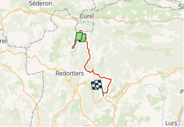
Trail Horseback riding Redortiers - Haute terre de Provence Jour 2 ( Retour : Contadour - Les Granges) - Photo

Haute terre de Provence Jour 2 ( Retour : Contadour - Les Granges)

© OpenStreetMap contributors
Length
Length
30 km
Max alt
Max alt
1428 m
Uphill gradient
Uphill gradient
553 m
Km-Effort
Km-Effort  
39 km
Min alt
Min alt
625 m
Downhill gradient
Downhill gradient
1125 m
Boucle
Boucle
No
Creation date :
2020-02-12 11:10:57.223
Updated on :
2020-10-31 17:37:56.78

(0 Reviews)

Horseback riding
Horseback riding
4h42
Difficulty : Difficult

Scan this QR Code to open this trail in the SityTrail application

FREE GPS app for hiking

Logo SityTrail SityTrail

IGN / Geographical institutes

Download SityTrail from the App Store Download SityTrail from Google Play

Logo SityTrail SityTrail World

The world is yours!

Download SityTrail from the App Store Download SityTrail from Google Play Download SityTrail on Huawei AppGallery

About

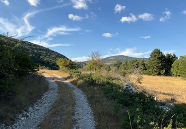
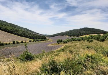
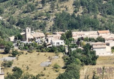
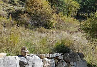
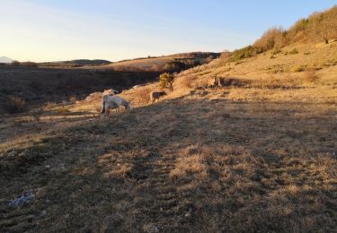
Trail Horseback riding of 30 km to be discovered at Provence-Alpes-Côte d'Azur, Alpes-de-Haute-Provence, Redortiers. This trail is proposed by les granges.

Description

Gîte d'étapes les Granges 0615224987

Elevation profile

Points of interest

Point of interest Redortiers - Gite du Trait - Photo
les granges
REDORTIERS 
Point of interest La Rochegiron - Créte des Fraches - Photo
les granges
LA ROCHEGIRON 
Point of interest La Rochegiron - Source de Font Martine  - Photo
les granges
Point of interest Lardiers - Déscente pièreuse  - Photo
les granges
Point of interest Lardiers - Fontaine de Lardiers - Photo
les granges

Positioning

Country:
France
Region :
Provence-Alpes-Côte d'Azur
Department/Province :
Alpes-de-Haute-Provence
Municipality :
Redortiers
Location:
Unknown
Start:(UTM)
710261 ; 4887826 (31T) N.

Trails nearby

Trail Walking La Rochegiron - la rochegiron 04.fon Martine, la blanchere, veire - Photo
Walking
Roger

Walking

Medium
La Rochegiron, Provence-Alpes-Côte d'Azur, Alpes-de-Haute-Provence, France
8.7 km | 12.4 km-effort
2h 52min
Yes
Trail Walking La Rochegiron - la rochegiron. vievre. la blanchete - Photo
Walking
Roger

Walking

Medium
La Rochegiron, Provence-Alpes-Côte d'Azur, Alpes-de-Haute-Provence, France
10.1 km | 14.3 km-effort
3h 44min
Yes
Trail Walking La Rochegiron - Vières - Font Martine - La Blanchère - Photo
Walking
dsurin

Walking

Easy
La Rochegiron, Provence-Alpes-Côte d'Azur, Alpes-de-Haute-Provence, France
9 km | 12 km-effort
2h 26min
Yes
Trail Walking Les Omergues - Saint André de villeseche. la pyramide du moine  - Photo
Walking
Roger

Walking

Medium
Les Omergues, Provence-Alpes-Côte d'Azur, Alpes-de-Haute-Provence, France
10 km | 13.6 km-effort
4h 0min
Yes
Trail Walking Saumane - Bergeries du Contras depuis Saumane - Photo
Walking
Daniel.BRUN-PICARD

Walking

Medium
(2)
Saumane, Provence-Alpes-Côte d'Azur, Alpes-de-Haute-Provence, France
12.1 km | 18.3 km-effort
3h 23min
Yes
Trail Walking La Rochegiron - 04 - VIERE, la Font Martine  - Photo
Walking
chris13370

Walking

Easy
La Rochegiron, Provence-Alpes-Côte d'Azur, Alpes-de-Haute-Provence, France
7.9 km | 11.6 km-effort
2h 30min
Yes
Trail Walking Redortiers - Bergeries du Contadour. (25-12-18). - Photo
Walking
Dervalmarc

Walking

Medium
Redortiers, Provence-Alpes-Côte d'Azur, Alpes-de-Haute-Provence, France
13.2 km | 17.7 km-effort
2h 55min
No
Trail Walking La Rochegiron - Petite balade depuis le Jonquet (La Rochegiron - 04) - Photo
Walking
dsurin

Walking

Easy
La Rochegiron, Provence-Alpes-Côte d'Azur, Alpes-de-Haute-Provence, France
4 km | 5.9 km-effort
1h 18min
No
Trail Walking Redortiers - autour du vieux Redortiers ( Aubignane)  - Photo
Walking
PITOUSSAINT

Walking

Medium
Redortiers, Provence-Alpes-Côte d'Azur, Alpes-de-Haute-Provence, France
7 km | 9.7 km-effort
3h 28min
Yes


Close
My subscriptions