![](/images/other/stat-length.png)
![Trail Walking Vaugneray - vaugneray 11022020 - Photo](https://media.geolcdn.com/t/1900/400/ext.pjpeg?maxdim=2&url=https%3A%2F%2Fstatic1.geolcdn.com%2Fsiteimages%2Fupload%2Ffiles%2F1553511878bg_sport_marche.png)
vaugneray 11022020
Jean-Luc Villermaux
User
![Length](/images/other/stat-length.png)
Length
10.2 km
![Max alt](https://static1.geolcdn.com/siteimages/upload/files/1508320355ic_sort_altitude_max_24dp.png)
Max alt
812 m
![Uphill gradient](https://static1.geolcdn.com/siteimages/upload/files/1508320355ic_sort_den_pos_24dp.png)
Uphill gradient
422 m
![Km-Effort](/images/other/stat-length.png)
Km-Effort
16.1 km
![Min alt](https://static1.geolcdn.com/siteimages/upload/files/1508320355ic_sort_altitude_min_24dp.png)
Min alt
373 m
![Downhill gradient](https://static1.geolcdn.com/siteimages/upload/files/1508320355ic_sort_den_neg_24dp.png)
Downhill gradient
505 m
![Boucle](https://static1.geolcdn.com/siteimages/upload/files/16400158638029165_repeat_loop_refresh_sync_direction_icon.png)
Boucle
No
Creation date :
2020-02-11 12:34:38.666
Updated on :
2020-02-11 19:13:23.086
![Walking](https://static1.geolcdn.com/sitytour/trail-icons/101.png)
3h43
Difficulty : Difficult
![Scan this QR Code to open this trail in the SityTrail application](https://capi.geolives.com/qq0zvz2zws4bq2lad0pu/sitytour/trails/2331568/qr.png?size=200)
FREE GPS app for hiking
About
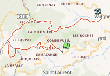
Trail Walking of 10.2 km to be discovered at Auvergne-Rhône-Alpes, Rhône, Vaugneray. This trail is proposed by Jean-Luc Villermaux.
Description
Une balade pour randonneurs endurants avec très peu de goudron et une magnifique vue sur Lyon à la cote 812. Trace de l'aqueduc romain à la cote 680
Positioning
Country:
France
Region :
Auvergne-Rhône-Alpes
Department/Province :
Rhône
Municipality :
Vaugneray
Location:
Vaugneray
Start:(Dec)
Start:(UTM)
627107 ; 5064600 (31T) N.
Comments
Trails nearby
![Trail Walking Pollionnay - Pollionnay, Croix du Ban, la Luère 7,5 Km - Photo](https://media.geolcdn.com/t/375/260/ext.jpg?maxdim=2&url=https%3A%2F%2Fservices.sitytrail.com%2FGeolivesWS%2FDownloadMedia.ashx%3FTrailID%3D104654%26Media%3D8048_4.jpg)
![Walking Walking](https://static1.geolcdn.com/sitytour/trail-icons/101.png)
Pollionnay, Croix du Ban, la Luère 7,5 Km
Walking
Medium
(2)
Pollionnay,
Auvergne-Rhône-Alpes,
Rhône,
France
![](/images/other/stat-length.png)
7.3 km | 12 km-effort
2h 0min
![](https://static1.geolcdn.com/siteimages/upload/files/16400158638029165_repeat_loop_refresh_sync_direction_icon.png)
Yes
![Trail Walking Pollionnay - Pollionnay - Col de la Croix du Ban - Saint Bel - Photo](https://media.geolcdn.com/t/375/260/8ef9381a-0165-43ee-bec7-dd3c247c912c.jpg&format=jpg&maxdim=2)
![Walking Walking](https://static1.geolcdn.com/sitytour/trail-icons/101.png)
Pollionnay - Col de la Croix du Ban - Saint Bel
Walking
Very difficult
(1)
Pollionnay,
Auvergne-Rhône-Alpes,
Rhône,
France
![](/images/other/stat-length.png)
28 km | 40 km-effort
9h 9min
![](https://static1.geolcdn.com/siteimages/upload/files/16400158638029165_repeat_loop_refresh_sync_direction_icon.png)
Yes
![Trail Walking Messimy - De Messimy au belvédère du Piragoy en boucle - Photo](https://media.geolcdn.com/t/375/260/4f6a03fe-103d-4ea3-ac7c-d9a11a0a7724.jpg&format=jpg&maxdim=2)
![Walking Walking](https://static1.geolcdn.com/sitytour/trail-icons/101.png)
De Messimy au belvédère du Piragoy en boucle
Walking
Easy
(1)
Messimy,
Auvergne-Rhône-Alpes,
Rhône,
France
![](/images/other/stat-length.png)
9.6 km | 13.6 km-effort
2h 31min
![](https://static1.geolcdn.com/siteimages/upload/files/16400158638029165_repeat_loop_refresh_sync_direction_icon.png)
Yes
![Trail Walking Vaugneray - Sur les hauteurs de Vaugneray - Photo](https://media.geolcdn.com/t/375/260/ext.jpg?maxdim=2&url=https%3A%2F%2Fservices.sitytrail.com%2FGeolivesWS%2FDownloadMedia.ashx%3FTrailID%3D106070%26Media%3D10246_2.jpg)
![Walking Walking](https://static1.geolcdn.com/sitytour/trail-icons/101.png)
Sur les hauteurs de Vaugneray
Walking
Medium
(4)
Vaugneray,
Auvergne-Rhône-Alpes,
Rhône,
France
![](/images/other/stat-length.png)
12.5 km | 19.2 km-effort
4h 0min
![](https://static1.geolcdn.com/siteimages/upload/files/16400158638029165_repeat_loop_refresh_sync_direction_icon.png)
Yes
![Trail Walking Courzieu - 2023-05-11_18h58m29_Fiche Verte n°5_Courzieu - Photo](https://media.geolcdn.com/t/375/260/ext.jpg?maxdim=2&url=https%3A%2F%2Fstatic1.geolcdn.com%2Fsiteimages%2Fupload%2Ffiles%2F1553511878bg_sport_marche.png)
![Walking Walking](https://static1.geolcdn.com/sitytour/trail-icons/101.png)
2023-05-11_18h58m29_Fiche Verte n°5_Courzieu
Walking
Difficult
(1)
Courzieu,
Auvergne-Rhône-Alpes,
Rhône,
France
![](/images/other/stat-length.png)
9 km | 15 km-effort
3h 23min
![](https://static1.geolcdn.com/siteimages/upload/files/16400158638029165_repeat_loop_refresh_sync_direction_icon.png)
Yes
![Trail Walking Vaugneray - Vaugneray - Lac D'Yseron- Parc Animalier de Courzieu - Photo](https://media.geolcdn.com/t/375/260/562e06b9-621d-475c-8be3-41f24f4bbed6.jpg&format=jpg&maxdim=2)
![Walking Walking](https://static1.geolcdn.com/sitytour/trail-icons/101.png)
Vaugneray - Lac D'Yseron- Parc Animalier de Courzieu
Walking
Very difficult
(1)
Vaugneray,
Auvergne-Rhône-Alpes,
Rhône,
France
![](/images/other/stat-length.png)
38 km | 58 km-effort
13h 13min
![](https://static1.geolcdn.com/siteimages/upload/files/16400158638029165_repeat_loop_refresh_sync_direction_icon.png)
Yes
![Trail Mountain bike Vaugneray - Belle boucle! 800m sur 24kms. - Photo](https://media.geolcdn.com/t/375/260/ext.jpg?maxdim=2&url=https%3A%2F%2Fstatic1.geolcdn.com%2Fsiteimages%2Fupload%2Ffiles%2F1524743154velo.jpg)
![Mountain bike Mountain bike](https://static1.geolcdn.com/sitytour/trail-icons/202.png)
Belle boucle! 800m sur 24kms.
Mountain bike
Medium
(1)
Vaugneray,
Auvergne-Rhône-Alpes,
Rhône,
France
![](/images/other/stat-length.png)
25 km | 36 km-effort
3h 0min
![](https://static1.geolcdn.com/siteimages/upload/files/16400158638029165_repeat_loop_refresh_sync_direction_icon.png)
Yes
![Trail Mountain bike Messimy - monté technique - Photo](https://media.geolcdn.com/t/375/260/ext.jpg?maxdim=2&url=https%3A%2F%2Fstatic1.geolcdn.com%2Fsiteimages%2Fupload%2Ffiles%2F1524743154velo.jpg)
![Mountain bike Mountain bike](https://static1.geolcdn.com/sitytour/trail-icons/202.png)
monté technique
Mountain bike
Difficult
(1)
Messimy,
Auvergne-Rhône-Alpes,
Rhône,
France
![](/images/other/stat-length.png)
26 km | 41 km-effort
3h 15min
![](https://static1.geolcdn.com/siteimages/upload/files/16400158638029165_repeat_loop_refresh_sync_direction_icon.png)
Yes
![Trail Mountain bike Vaugneray - VTT VAUGNERAY - Photo](https://media.geolcdn.com/t/375/260/ext.jpg?maxdim=2&url=https%3A%2F%2Fstatic1.geolcdn.com%2Fsiteimages%2Fupload%2Ffiles%2F1524743154velo.jpg)
![Mountain bike Mountain bike](https://static1.geolcdn.com/sitytour/trail-icons/202.png)
VTT VAUGNERAY
Mountain bike
Difficult
(1)
Vaugneray,
Auvergne-Rhône-Alpes,
Rhône,
France
![](/images/other/stat-length.png)
17.4 km | 26 km-effort
Unknown
![](https://static1.geolcdn.com/siteimages/upload/files/16400158638029165_repeat_loop_refresh_sync_direction_icon.png)
Yes