


1200 stars kauri tree

gerardprovost
User
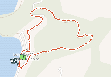

Length
1.7 km

Max alt
78 m

Uphill gradient
63 m
Km-Effort
2.5 km

Min alt
4 m

Downhill gradient
68 m
Boucle
Yes
Creation date :
2020-02-10 01:20:56.492
Updated on :
2020-02-10 02:06:27.643
44m
Difficulty : Very easy

FREE GPS app for hiking
 SityTrail
IGN / Geographical institutes
SityTrail World
The world is yours!
About
Trail Walking of 1.7 km to be discovered at Waikato, Thames Coromandel District. This trail is proposed by gerardprovost.
Positioning
Country:
New Zealand
Region :
Waikato
Department/Province :
Thames Coromandel District
Municipality :
Long
Location:
Unknown
Start:(Dec)
Start:(UTM)
364018 ; 5932109 (60H) S.
Comments
Trails nearby