Trail On foot Nébouzat - Nebouzat Les Quatre Routes Anterioux Bravant - Photo

Nebouzat Les Quatre Routes Anterioux Bravant

 jeanic63
jeanic63

User

© OpenStreetMap contributors
Length
Length
23 km
Max alt
Max alt
1059 m
Uphill gradient
Uphill gradient
473 m
Km-Effort
Km-Effort  
30 km
Min alt
Min alt
774 m
Downhill gradient
Downhill gradient
472 m
Boucle
Boucle
Yes
Creation date :
2020-02-07 10:24:35.351
Updated on :
2024-01-22 19:53:45.421

(0 Reviews)

On foot
On foot
6h42
Difficulty : Medium

Scan this QR Code to open this trail in the SityTrail application

FREE GPS app for hiking

Logo SityTrail SityTrail

IGN / Geographical institutes

Download SityTrail from the App Store Download SityTrail from Google Play

Logo SityTrail SityTrail World

The world is yours!

Download SityTrail from the App Store Download SityTrail from Google Play Download SityTrail on Huawei AppGallery

About

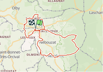
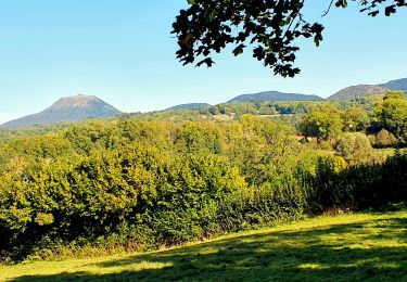
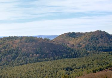
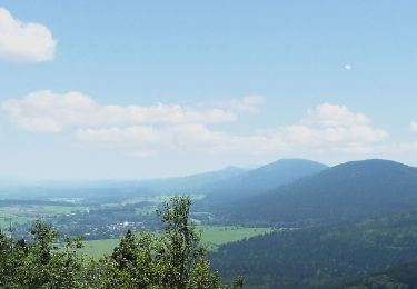
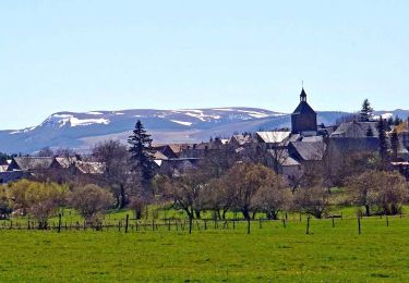
Trail On foot of 23 km to be discovered at Auvergne-Rhône-Alpes, Puy-de-Dôme, Nébouzat. This trail is proposed by jeanic63.

Description

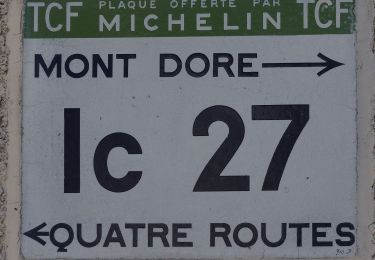
départ parking restaurant Sancy des Volcans au rond point des Quatre Routes

Elevation profile

Positioning

Country:
France
Region :
Auvergne-Rhône-Alpes
Department/Province :
Puy-de-Dôme
Municipality :
Nébouzat
Location:
Unknown
Start:(UTM)
491523 ; 5063726 (31T) N.

Trails nearby

Trail Walking Saint-Bonnet-près-Orcival - St_Bonnet_Orcival_Sioule - Photo
Walking
GUIDE
jagarnier

Walking

Easy
(1)
Saint-Bonnet-près-Orcival, Auvergne-Rhône-Alpes, Puy-de-Dôme, France
9.4 km | 11.8 km-effort
2h 45min
Yes
Trail Walking Aydat - Lassolas-La Vache-Vichatel - Photo
Walking
pidjam

Walking

Medium
(1)
Aydat, Auvergne-Rhône-Alpes, Puy-de-Dôme, France
13.2 km | 18.6 km-effort
4h 4min
Yes
Trail On foot Olby - Boucle des dômes - Photo
On foot
PRO

On foot

Difficult
Olby, Auvergne-Rhône-Alpes, Puy-de-Dôme, France
24 km | 34 km-effort
7h 46min
No
Trail On foot Nébouzat - Le Puy de Pourcharet - Photo
On foot
PRO

On foot

Medium
Nébouzat, Auvergne-Rhône-Alpes, Puy-de-Dôme, France
19 km | 24 km-effort
5h 23min
Yes
Trail On foot Orcival - Bois des Bourelles - Photo
On foot
PRO

On foot

Easy
Orcival, Auvergne-Rhône-Alpes, Puy-de-Dôme, France
6.9 km | 10.1 km-effort
2h 17min
Yes
Trail Walking Aydat - 20150607 La chaîne des puys endormis - Photo
Walking
Fabricecha

Walking

Medium
(3)
Aydat, Auvergne-Rhône-Alpes, Puy-de-Dôme, France
8.2 km | 12.2 km-effort
2h 33min
Yes
Trail Walking Aurières - Auriere_Gorce_Sioule - Photo
Walking
GUIDE
jagarnier

Walking

Medium
(1)
Aurières, Auvergne-Rhône-Alpes, Puy-de-Dôme, France
14.4 km | 19 km-effort
4h 15min
Yes
Trail Walking Orcival - Orcival_Bois_Bourelles - Photo
Walking
GUIDE
jagarnier

Walking

Easy
Orcival, Auvergne-Rhône-Alpes, Puy-de-Dôme, France
6.9 km | 10.1 km-effort
2h 0min
Yes
Trail Walking Nébouzat - Nébouzat_Cascade_Saliens - Photo
Walking
GUIDE
jagarnier

Walking

Medium
Nébouzat, Auvergne-Rhône-Alpes, Puy-de-Dôme, France
13 km | 17 km-effort
3h 45min
Yes


Close
My subscriptions