![](/images/other/stat-length.png)
![Trail Walking Champcevinel - Champcevinel Chantecoucou - Photo](https://media.geolcdn.com/t/1900/400/ext.pjpeg?maxdim=2&url=https%3A%2F%2Fstatic1.geolcdn.com%2Fsiteimages%2Fupload%2Ffiles%2F1553511878bg_sport_marche.png)
Champcevinel Chantecoucou
YV24
User
![Length](/images/other/stat-length.png)
Length
13.4 km
![Max alt](https://static1.geolcdn.com/siteimages/upload/files/1508320355ic_sort_altitude_max_24dp.png)
Max alt
233 m
![Uphill gradient](https://static1.geolcdn.com/siteimages/upload/files/1508320355ic_sort_den_pos_24dp.png)
Uphill gradient
256 m
![Km-Effort](/images/other/stat-length.png)
Km-Effort
16.8 km
![Min alt](https://static1.geolcdn.com/siteimages/upload/files/1508320355ic_sort_altitude_min_24dp.png)
Min alt
110 m
![Downhill gradient](https://static1.geolcdn.com/siteimages/upload/files/1508320355ic_sort_den_neg_24dp.png)
Downhill gradient
257 m
![Boucle](https://static1.geolcdn.com/siteimages/upload/files/16400158638029165_repeat_loop_refresh_sync_direction_icon.png)
Boucle
Yes
Creation date :
2014-12-10 00:00:00.0
Updated on :
2023-04-29 11:07:02.644
![Walking](https://static1.geolcdn.com/sitytour/trail-icons/101.png)
3h37
Difficulty : Easy
![Scan this QR Code to open this trail in the SityTrail application](https://capi.geolives.com/qq0zvz2zws4bq2lad0pu/sitytour/trails/232625/qr.png?size=200)
FREE GPS app for hiking
About
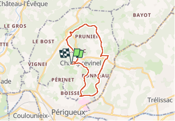
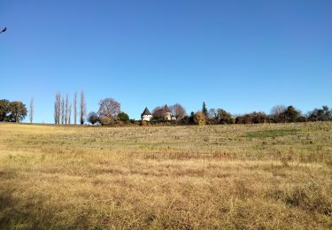
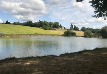
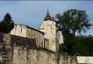
Trail Walking of 13.4 km to be discovered at New Aquitaine, Dordogne, Champcevinel. This trail is proposed by YV24.
Description
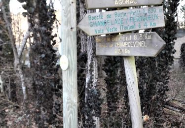
Selon PDIPR Tracé en partie urbain et semi urbain, varié. Beaucoup de bitume. Bien balisé. Praticable par tous les temps.
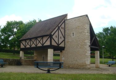
Tracé sans grand intérêt, comparé à d'autres circuits environnant.
Positioning
Country:
France
Region :
New Aquitaine
Department/Province :
Dordogne
Municipality :
Champcevinel
Location:
Unknown
Start:(Dec)
Start:(UTM)
321054 ; 5009350 (31T) N.
Comments
Trails nearby
![Trail Walking Trélissac - Trélissac Puyconteau 10km - Photo](https://media.geolcdn.com/t/375/260/ext.jpg?maxdim=2&url=https%3A%2F%2Fstatic1.geolcdn.com%2Fsiteimages%2Fupload%2Ffiles%2F1553511878bg_sport_marche.png)
![Walking Walking](https://static1.geolcdn.com/sitytour/trail-icons/101.png)
Trélissac Puyconteau 10km
Walking
Easy
(2)
Trélissac,
New Aquitaine,
Dordogne,
France
![](/images/other/stat-length.png)
9.7 km | 12.7 km-effort
2h 44min
![](https://static1.geolcdn.com/siteimages/upload/files/16400158638029165_repeat_loop_refresh_sync_direction_icon.png)
Yes
![Trail Nordic walking Trélissac - petite - Photo](https://media.geolcdn.com/t/375/260/ext.jpg?maxdim=2&url=https%3A%2F%2Fstatic1.geolcdn.com%2Fsiteimages%2Fupload%2Ffiles%2F1545311037marcheuse_200dpi.jpg)
![Nordic walking Nordic walking](https://static1.geolcdn.com/sitytour/trail-icons/102.png)
petite
Nordic walking
Very easy
(1)
Trélissac,
New Aquitaine,
Dordogne,
France
![](/images/other/stat-length.png)
8.6 km | 11.7 km-effort
1h 59min
![](https://static1.geolcdn.com/siteimages/upload/files/16400158638029165_repeat_loop_refresh_sync_direction_icon.png)
No
![Trail Walking Boulazac Isle Manoire - Boulazac à partir du Palio - Photo](https://media.geolcdn.com/t/375/260/ext.jpg?maxdim=2&url=https%3A%2F%2Fservices.sitytrail.com%2FGeolivesWS%2FDownloadMedia.ashx%3FTrailID%3D317879%26Media%3D17272_6.jpg)
![Walking Walking](https://static1.geolcdn.com/sitytour/trail-icons/101.png)
Boulazac à partir du Palio
Walking
Medium
(1)
Boulazac Isle Manoire,
New Aquitaine,
Dordogne,
France
![](/images/other/stat-length.png)
7.3 km | 9 km-effort
1h 45min
![](https://static1.geolcdn.com/siteimages/upload/files/16400158638029165_repeat_loop_refresh_sync_direction_icon.png)
Yes
![Trail Walking Boulazac Isle Manoire - Octobre rose Boulazac 2022 - Photo](https://media.geolcdn.com/t/375/260/e41a1f45-65e7-47fa-b801-6540904164c7.jpg&format=jpg&maxdim=2)
![Walking Walking](https://static1.geolcdn.com/sitytour/trail-icons/101.png)
Octobre rose Boulazac 2022
Walking
Easy
Boulazac Isle Manoire,
New Aquitaine,
Dordogne,
France
![](/images/other/stat-length.png)
7.7 km | 8.9 km-effort
1h 42min
![](https://static1.geolcdn.com/siteimages/upload/files/16400158638029165_repeat_loop_refresh_sync_direction_icon.png)
Yes
![Trail Walking Champcevinel - champcevinel - Photo](https://media.geolcdn.com/t/375/260/ee6533d5-1951-437a-84ea-112f8c5e298d.jpg&format=jpg&maxdim=2)
![Walking Walking](https://static1.geolcdn.com/sitytour/trail-icons/101.png)
champcevinel
Walking
Difficult
Champcevinel,
New Aquitaine,
Dordogne,
France
![](/images/other/stat-length.png)
9.7 km | 12.3 km-effort
2h 48min
![](https://static1.geolcdn.com/siteimages/upload/files/16400158638029165_repeat_loop_refresh_sync_direction_icon.png)
Yes
![Trail Walking Trélissac - Boucle de Lauterie insolite - Photo](https://media.geolcdn.com/t/375/260/a0da6d9a-9953-4a09-b76c-865d9abf1482.jpg&format=jpg&maxdim=2)
![Walking Walking](https://static1.geolcdn.com/sitytour/trail-icons/101.png)
Boucle de Lauterie insolite
Walking
Easy
Trélissac,
New Aquitaine,
Dordogne,
France
![](/images/other/stat-length.png)
10.9 km | 14.6 km-effort
3h 28min
![](https://static1.geolcdn.com/siteimages/upload/files/16400158638029165_repeat_loop_refresh_sync_direction_icon.png)
Yes
![Trail Walking Chancelade - Circuit de l'Abbaye de Chancelade - Photo](https://media.geolcdn.com/t/375/260/16bcd257-155c-4b42-a479-9684c98ab4d4.jpg&format=jpg&maxdim=2)
![Walking Walking](https://static1.geolcdn.com/sitytour/trail-icons/101.png)
Circuit de l'Abbaye de Chancelade
Walking
Difficult
Chancelade,
New Aquitaine,
Dordogne,
France
![](/images/other/stat-length.png)
12.8 km | 18.3 km-effort
4h 9min
![](https://static1.geolcdn.com/siteimages/upload/files/16400158638029165_repeat_loop_refresh_sync_direction_icon.png)
Yes
![Trail Walking Cornille - Boucle de l étang Cornille par Pognac et Lafayardie - Photo](https://media.geolcdn.com/t/375/260/9db332a4-5555-47bf-93a5-6e867e2bdf1f.jpg&format=jpg&maxdim=2)
![Walking Walking](https://static1.geolcdn.com/sitytour/trail-icons/101.png)
Boucle de l étang Cornille par Pognac et Lafayardie
Walking
Easy
Cornille,
New Aquitaine,
Dordogne,
France
![](/images/other/stat-length.png)
7 km | 8.6 km-effort
2h 43min
![](https://static1.geolcdn.com/siteimages/upload/files/16400158638029165_repeat_loop_refresh_sync_direction_icon.png)
Yes
![Trail Walking Château-l'Évêque - Boucle du bois de Lavergne - Photo](https://media.geolcdn.com/t/375/260/6537e41d-5ba3-471f-b695-a5c123990690.jpg&format=jpg&maxdim=2)
![Walking Walking](https://static1.geolcdn.com/sitytour/trail-icons/101.png)
Boucle du bois de Lavergne
Walking
Difficult
Château-l'Évêque,
New Aquitaine,
Dordogne,
France
![](/images/other/stat-length.png)
14.1 km | 17.8 km-effort
4h 2min
![](https://static1.geolcdn.com/siteimages/upload/files/16400158638029165_repeat_loop_refresh_sync_direction_icon.png)
Yes