![](/images/other/stat-length.png)
![Trail Walking Otívar - OTIVAR Castillo Moscaril - Photo](https://media.geolcdn.com/t/1900/400/0f691502-7702-4e97-b4a7-20ff68f93bf9.jpg&format=pjpeg&maxdim=2)
OTIVAR Castillo Moscaril
jpipacific
User
![Length](/images/other/stat-length.png)
![Max alt](https://static1.geolcdn.com/siteimages/upload/files/1508320355ic_sort_altitude_max_24dp.png)
![Uphill gradient](https://static1.geolcdn.com/siteimages/upload/files/1508320355ic_sort_den_pos_24dp.png)
![Km-Effort](/images/other/stat-length.png)
![Min alt](https://static1.geolcdn.com/siteimages/upload/files/1508320355ic_sort_altitude_min_24dp.png)
![Downhill gradient](https://static1.geolcdn.com/siteimages/upload/files/1508320355ic_sort_den_neg_24dp.png)
![Boucle](https://static1.geolcdn.com/siteimages/upload/files/16400158638029165_repeat_loop_refresh_sync_direction_icon.png)
![Walking](https://static1.geolcdn.com/sitytour/trail-icons/101.png)
1h58
Difficulty : Medium
![Scan this QR Code to open this trail in the SityTrail application](https://capi.geolives.com/qq0zvz2zws4bq2lad0pu/sitytour/trails/2325972/qr.png?size=200)
FREE GPS app for hiking
About
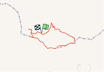
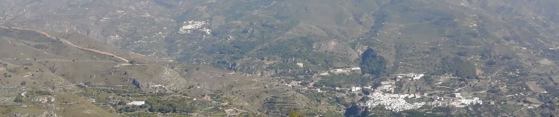
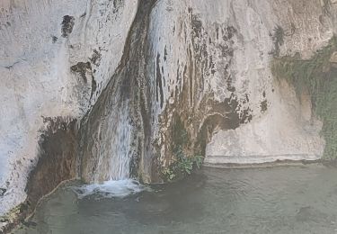
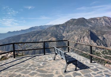
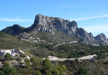
Trail Walking of 4.1 km to be discovered at Andalusia, Granada, Otívar. This trail is proposed by jpipacific.
Description
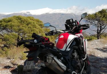
Accès au départ assez difficile sans 4X4 ou moto Trail ce qui est mon cas. A moins de partir de plus loin.
Rando assez difficile. Les dénivelés sont assez sévères.
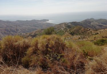
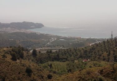
Les paysages sont très beaux avec vues sur la mer, sur les pointes de la Sierra Nevada et sur toutes les montagnes alentour.
Positioning
Comments
Trails nearby
![Trail Walking Lentegí - Poza de las animas - Photo](https://media.geolcdn.com/t/375/260/138d79bf-c8e6-4959-ad11-fb1767b7d5eb.jpg&format=jpg&maxdim=2)
![Walking Walking](https://static1.geolcdn.com/sitytour/trail-icons/101.png)
Walking
![](/images/other/stat-length.png)
![](https://static1.geolcdn.com/siteimages/upload/files/16400158638029165_repeat_loop_refresh_sync_direction_icon.png)
![Trail Walking Lentegí - Lentegi Las Bizarras - Photo](https://media.geolcdn.com/t/375/260/6e3b7bc9-1a0d-4a1d-bbbf-2f25e6bc75de.jpg&format=jpg&maxdim=2)
![Walking Walking](https://static1.geolcdn.com/sitytour/trail-icons/101.png)
Walking
![](/images/other/stat-length.png)
![](https://static1.geolcdn.com/siteimages/upload/files/16400158638029165_repeat_loop_refresh_sync_direction_icon.png)
![Trail Moto cross Lentegí - Lentegi Vélez de Benaudalla - Photo](https://media.geolcdn.com/t/375/260/82f69f2a-fa53-4f07-aef5-63c3aeaa5dc3.jpg&format=jpg&maxdim=2)
![Moto cross Moto cross](https://static1.geolcdn.com/sitytour/trail-icons/406.png)
Moto cross
![](/images/other/stat-length.png)
![](https://static1.geolcdn.com/siteimages/upload/files/16400158638029165_repeat_loop_refresh_sync_direction_icon.png)
![Trail Walking Almuñécar - Rescate au dessus - Photo](https://media.geolcdn.com/t/375/260/ec5fb466-62dd-4930-bc43-4267f1602454.jpg&format=jpg&maxdim=2)
![Walking Walking](https://static1.geolcdn.com/sitytour/trail-icons/101.png)
Walking
![](/images/other/stat-length.png)
![](https://static1.geolcdn.com/siteimages/upload/files/16400158638029165_repeat_loop_refresh_sync_direction_icon.png)
![Trail Walking Almuñécar - Au dessus de EL CERVAL - Photo](https://media.geolcdn.com/t/375/260/8cdb8405-48e9-44ea-a73a-31deabc2a61b.jpg&format=jpg&maxdim=2)
![Walking Walking](https://static1.geolcdn.com/sitytour/trail-icons/101.png)
Walking
![](/images/other/stat-length.png)
![](https://static1.geolcdn.com/siteimages/upload/files/16400158638029165_repeat_loop_refresh_sync_direction_icon.png)
![Trail On foot Almuñécar - OTIVAR castillo Moscaril tour 2 - Photo](https://media.geolcdn.com/t/375/260/9f70cda7-72e7-4555-909c-15377c7c2dd6.jpg&format=jpg&maxdim=2)
![On foot On foot](https://static1.geolcdn.com/sitytour/trail-icons/100.png)
On foot
![](/images/other/stat-length.png)
![](https://static1.geolcdn.com/siteimages/upload/files/16400158638029165_repeat_loop_refresh_sync_direction_icon.png)
![Trail Walking Almuñécar - Chemin de liaison El Cerval et Rescate - Photo](https://media.geolcdn.com/t/375/260/b00f9877-b089-4103-b8e5-b461cae5c9d5.jpg&format=jpg&maxdim=2)
![Walking Walking](https://static1.geolcdn.com/sitytour/trail-icons/101.png)
Walking
![](/images/other/stat-length.png)
![](https://static1.geolcdn.com/siteimages/upload/files/16400158638029165_repeat_loop_refresh_sync_direction_icon.png)
![Walking Walking](https://static1.geolcdn.com/sitytour/trail-icons/101.png)
Walking
![](/images/other/stat-length.png)
![](https://static1.geolcdn.com/siteimages/upload/files/16400158638029165_repeat_loop_refresh_sync_direction_icon.png)
![Trail Walking Almuñécar - Wikiloc - El Rescate - Photo](https://media.geolcdn.com/t/375/260/ext.jpg?maxdim=2&url=https%3A%2F%2Fstatic1.geolcdn.com%2Fsiteimages%2Fupload%2Ffiles%2F1553511878bg_sport_marche.png)
![Walking Walking](https://static1.geolcdn.com/sitytour/trail-icons/101.png)
Walking
![](/images/other/stat-length.png)
![](https://static1.geolcdn.com/siteimages/upload/files/16400158638029165_repeat_loop_refresh_sync_direction_icon.png)