![](/images/other/stat-length.png)
![Trail Nordic walking Dourdan - DOURDAN Les Fontaines Bouillantes - Photo](https://media.geolcdn.com/t/1900/400/ext.pjpeg?maxdim=2&url=https%3A%2F%2Fstatic1.geolcdn.com%2Fsiteimages%2Fupload%2Ffiles%2F1545311037marcheuse_200dpi.jpg)
DOURDAN Les Fontaines Bouillantes
PascalROBINET
User
![Length](/images/other/stat-length.png)
Length
7.5 km
![Max alt](https://static1.geolcdn.com/siteimages/upload/files/1508320355ic_sort_altitude_max_24dp.png)
Max alt
168 m
![Uphill gradient](https://static1.geolcdn.com/siteimages/upload/files/1508320355ic_sort_den_pos_24dp.png)
Uphill gradient
133 m
![Km-Effort](/images/other/stat-length.png)
Km-Effort
9.3 km
![Min alt](https://static1.geolcdn.com/siteimages/upload/files/1508320355ic_sort_altitude_min_24dp.png)
Min alt
96 m
![Downhill gradient](https://static1.geolcdn.com/siteimages/upload/files/1508320355ic_sort_den_neg_24dp.png)
Downhill gradient
129 m
![Boucle](https://static1.geolcdn.com/siteimages/upload/files/16400158638029165_repeat_loop_refresh_sync_direction_icon.png)
Boucle
No
Creation date :
2020-02-05 21:55:16.605
Updated on :
2020-02-05 22:01:59.225
![Nordic walking](https://static1.geolcdn.com/sitytour/trail-icons/102.png)
1h40
Difficulty : Very easy
![Scan this QR Code to open this trail in the SityTrail application](https://capi.geolives.com/qq0zvz2zws4bq2lad0pu/sitytour/trails/2325479/qr.png?size=200)
FREE GPS app for hiking
About
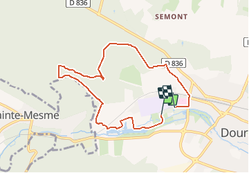
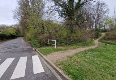
Trail Nordic walking of 7.5 km to be discovered at Ile-de-France, Essonne, Dourdan. This trail is proposed by PascalROBINET.
Description
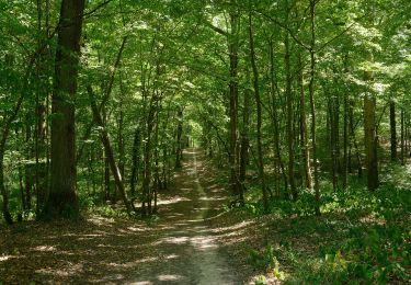
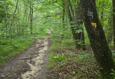
Pacours de Marche Nordique dans la forêt de DOURDAN 91, proche de l'hôpital. Passage près de l'Orge, étangs et fontaines bouillantes.
RDV au parking en contrebas de l'hôpital, au drapeau arrivée.
Positioning
Country:
France
Region :
Ile-de-France
Department/Province :
Essonne
Municipality :
Dourdan
Location:
Unknown
Start:(Dec)
Start:(UTM)
425771 ; 5375907 (31U) N.
Comments
Trails nearby
![Trail On foot Sainte-Mesme - Boucle en forêt de Dourdan au départ de Sainte Mesme - Photo](https://media.geolcdn.com/t/375/260/991a29e9-cb59-4be9-8562-0b553941774b.jpg&format=jpg&maxdim=2)
![On foot On foot](https://static1.geolcdn.com/sitytour/trail-icons/100.png)
Boucle en forêt de Dourdan au départ de Sainte Mesme
On foot
Easy
Sainte-Mesme,
Ile-de-France,
Yvelines,
France
![](/images/other/stat-length.png)
21 km | 25 km-effort
5h 43min
![](https://static1.geolcdn.com/siteimages/upload/files/16400158638029165_repeat_loop_refresh_sync_direction_icon.png)
Yes
![Trail On foot Dourdan - FR-balisage orange en forêt de Dourdan à rattacher aux bons itinéraires - Photo](https://media.geolcdn.com/t/375/260/99ca014b-1f07-4134-9ad5-415403427eb3.jpeg&format=jpg&maxdim=2)
![On foot On foot](https://static1.geolcdn.com/sitytour/trail-icons/100.png)
FR-balisage orange en forêt de Dourdan à rattacher aux bons itinéraires
On foot
Easy
Dourdan,
Ile-de-France,
Essonne,
France
![](/images/other/stat-length.png)
5.8 km | 7.5 km-effort
1h 42min
![](https://static1.geolcdn.com/siteimages/upload/files/16400158638029165_repeat_loop_refresh_sync_direction_icon.png)
No
![Trail On foot Dourdan - Promenade de Nemours - Photo](https://media.geolcdn.com/t/375/260/0b265bef-bfde-43df-b5d7-8e18dc6cd16f.jpeg&format=jpg&maxdim=2)
![On foot On foot](https://static1.geolcdn.com/sitytour/trail-icons/100.png)
Promenade de Nemours
On foot
Easy
Dourdan,
Ile-de-France,
Essonne,
France
![](/images/other/stat-length.png)
4.5 km | 4.9 km-effort
1h 6min
![](https://static1.geolcdn.com/siteimages/upload/files/16400158638029165_repeat_loop_refresh_sync_direction_icon.png)
No
![Trail Nordic walking Dourdan - Forêt de Saint Arnoult - Photo](https://media.geolcdn.com/t/375/260/ext.jpg?maxdim=2&url=https%3A%2F%2Fstatic1.geolcdn.com%2Fsiteimages%2Fupload%2Ffiles%2F1545311037marcheuse_200dpi.jpg)
![Nordic walking Nordic walking](https://static1.geolcdn.com/sitytour/trail-icons/102.png)
Forêt de Saint Arnoult
Nordic walking
Easy
(1)
Dourdan,
Ile-de-France,
Essonne,
France
![](/images/other/stat-length.png)
8.6 km | 10.5 km-effort
1h 50min
![](https://static1.geolcdn.com/siteimages/upload/files/16400158638029165_repeat_loop_refresh_sync_direction_icon.png)
Yes
![Trail Walking Dourdan - Ste Mesme St Martin de Brethencourt - Photo](https://media.geolcdn.com/t/375/260/ext.jpg?maxdim=2&url=https%3A%2F%2Fstatic1.geolcdn.com%2Fsiteimages%2Fupload%2Ffiles%2F1553511878bg_sport_marche.png)
![Walking Walking](https://static1.geolcdn.com/sitytour/trail-icons/101.png)
Ste Mesme St Martin de Brethencourt
Walking
Medium
(2)
Dourdan,
Ile-de-France,
Essonne,
France
![](/images/other/stat-length.png)
14.9 km | 17.5 km-effort
5min
![](https://static1.geolcdn.com/siteimages/upload/files/16400158638029165_repeat_loop_refresh_sync_direction_icon.png)
Yes
![Trail Walking Les Granges-le-Roi - Forêt domaniale de Dourdan - Photo](https://media.geolcdn.com/t/375/260/3f0205b4-5d92-449d-bebb-1f366c91909e.jpg&format=jpg&maxdim=2)
![Walking Walking](https://static1.geolcdn.com/sitytour/trail-icons/101.png)
Forêt domaniale de Dourdan
Walking
Medium
Les Granges-le-Roi,
Ile-de-France,
Essonne,
France
![](/images/other/stat-length.png)
14.1 km | 17.4 km-effort
3h 57min
![](https://static1.geolcdn.com/siteimages/upload/files/16400158638029165_repeat_loop_refresh_sync_direction_icon.png)
Yes
![Trail On foot Dourdan - La Remarde et le Marais - Photo](https://media.geolcdn.com/t/375/260/ext.jpg?maxdim=2&url=https%3A%2F%2Fstatic1.geolcdn.com%2Fsiteimages%2Fupload%2Ffiles%2F1545311037marcheuse_200dpi.jpg)
![On foot On foot](https://static1.geolcdn.com/sitytour/trail-icons/100.png)
La Remarde et le Marais
On foot
Medium
(1)
Dourdan,
Ile-de-France,
Essonne,
France
![](/images/other/stat-length.png)
18.9 km | 23 km-effort
5h 19min
![](https://static1.geolcdn.com/siteimages/upload/files/16400158638029165_repeat_loop_refresh_sync_direction_icon.png)
No
![Trail Walking Dourdan - R2-Dourdan et sa forêt - Photo](https://media.geolcdn.com/t/375/260/ext.jpg?maxdim=2&url=https%3A%2F%2Fstatic1.geolcdn.com%2Fsiteimages%2Fupload%2Ffiles%2F1553511878bg_sport_marche.png)
![Walking Walking](https://static1.geolcdn.com/sitytour/trail-icons/101.png)
R2-Dourdan et sa forêt
Walking
Very difficult
(1)
Dourdan,
Ile-de-France,
Essonne,
France
![](/images/other/stat-length.png)
19.3 km | 24 km-effort
5h 23min
![](https://static1.geolcdn.com/siteimages/upload/files/16400158638029165_repeat_loop_refresh_sync_direction_icon.png)
Yes
![Trail Walking Saint-Arnoult-en-Yvelines - Yvelines_Saint-Arnoult=>BoisDeRochefort=>Rochefort - Photo](https://media.geolcdn.com/t/375/260/4db7159e-1f12-446b-909c-36750ce5637d.jpg&format=jpg&maxdim=2)
![Walking Walking](https://static1.geolcdn.com/sitytour/trail-icons/101.png)
Yvelines_Saint-Arnoult=>BoisDeRochefort=>Rochefort
Walking
Easy
Saint-Arnoult-en-Yvelines,
Ile-de-France,
Yvelines,
France
![](/images/other/stat-length.png)
11.8 km | 14.2 km-effort
3h 13min
![](https://static1.geolcdn.com/siteimages/upload/files/16400158638029165_repeat_loop_refresh_sync_direction_icon.png)
Yes