![](/images/other/stat-length.png)
![Trail On foot Cagnes-sur-Mer - GRP XYZ 1 - Photo](https://media.geolcdn.com/t/1900/400/ext.pjpeg?maxdim=2&url=https%3A%2F%2Fstatic1.geolcdn.com%2Fsiteimages%2Fupload%2Ffiles%2F1545311037marcheuse_200dpi.jpg)
GRP XYZ 1
REYPatrick
User
![Length](/images/other/stat-length.png)
Length
55 km
![Max alt](https://static1.geolcdn.com/siteimages/upload/files/1508320355ic_sort_altitude_max_24dp.png)
Max alt
348 m
![Uphill gradient](https://static1.geolcdn.com/siteimages/upload/files/1508320355ic_sort_den_pos_24dp.png)
Uphill gradient
1433 m
![Km-Effort](/images/other/stat-length.png)
Km-Effort
74 km
![Min alt](https://static1.geolcdn.com/siteimages/upload/files/1508320355ic_sort_altitude_min_24dp.png)
Min alt
0 m
![Downhill gradient](https://static1.geolcdn.com/siteimages/upload/files/1508320355ic_sort_den_neg_24dp.png)
Downhill gradient
1433 m
![Boucle](https://static1.geolcdn.com/siteimages/upload/files/16400158638029165_repeat_loop_refresh_sync_direction_icon.png)
Boucle
Yes
Creation date :
2020-02-03 09:44:56.06
Updated on :
2020-03-04 15:17:44.171
![On foot](https://static1.geolcdn.com/sitytour/trail-icons/100.png)
92h00
Difficulty : Medium
![Scan this QR Code to open this trail in the SityTrail application](https://capi.geolives.com/qq0zvz2zws4bq2lad0pu/sitytour/trails/2322683/qr.png?size=200)
FREE GPS app for hiking
About
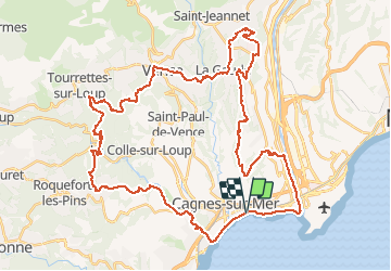
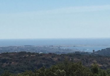
Trail On foot of 55 km to be discovered at Provence-Alpes-Côte d'Azur, Maritime Alps, Cagnes-sur-Mer. This trail is proposed by REYPatrick.
Description
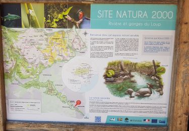
Cagnes sur Mer, Villeneuve loubet, Roquefort, La colle sur Loup, Tourette sur Loup, Vence, Saint Laurent du Var, Saint Paul de Vence.
Positioning
Country:
France
Region :
Provence-Alpes-Côte d'Azur
Department/Province :
Maritime Alps
Municipality :
Cagnes-sur-Mer
Location:
Unknown
Start:(Dec)
Start:(UTM)
352082 ; 4835418 (32T) N.
Comments
Trails nearby
![Trail Walking Villeneuve-Loubet - plateau montmeuil - Photo](https://media.geolcdn.com/t/375/260/ext.jpg?maxdim=2&url=https%3A%2F%2Fstatic1.geolcdn.com%2Fsiteimages%2Fupload%2Ffiles%2F1553511878bg_sport_marche.png)
![Walking Walking](https://static1.geolcdn.com/sitytour/trail-icons/101.png)
plateau montmeuil
Walking
Medium
(1)
Villeneuve-Loubet,
Provence-Alpes-Côte d'Azur,
Maritime Alps,
France
![](/images/other/stat-length.png)
7.3 km | 8.9 km-effort
2h 27min
![](https://static1.geolcdn.com/siteimages/upload/files/16400158638029165_repeat_loop_refresh_sync_direction_icon.png)
No
![Trail Walking Villeneuve-Loubet - Parc departemental des Rives du Loup. - Photo](https://media.geolcdn.com/t/375/260/ext.jpg?maxdim=2&url=https%3A%2F%2Fservices.sitytrail.com%2FGeolivesWS%2FDownloadMedia.ashx%3FTrailID%3D464702%26Media%3Dfix__20150827152618.jpg)
![Walking Walking](https://static1.geolcdn.com/sitytour/trail-icons/101.png)
Parc departemental des Rives du Loup.
Walking
Very easy
Villeneuve-Loubet,
Provence-Alpes-Côte d'Azur,
Maritime Alps,
France
![](/images/other/stat-length.png)
6.9 km | 8 km-effort
1h 23min
![](https://static1.geolcdn.com/siteimages/upload/files/16400158638029165_repeat_loop_refresh_sync_direction_icon.png)
Yes
![Trail Walking Cagnes-sur-Mer - Villeneuve Loubet - Photo](https://media.geolcdn.com/t/375/260/3697ac0e-a76a-452a-a0b6-1b4fef9af2a0.jpg&format=jpg&maxdim=2)
![Walking Walking](https://static1.geolcdn.com/sitytour/trail-icons/101.png)
Villeneuve Loubet
Walking
Easy
Cagnes-sur-Mer,
Provence-Alpes-Côte d'Azur,
Maritime Alps,
France
![](/images/other/stat-length.png)
13.3 km | 15.7 km-effort
6h 40min
![](https://static1.geolcdn.com/siteimages/upload/files/16400158638029165_repeat_loop_refresh_sync_direction_icon.png)
Yes
![Trail Nordic walking La Colle-sur-Loup - le long du Loup - Photo](https://media.geolcdn.com/t/375/260/323a9641-ff90-4c05-8bfa-f94db62a990b.jpg&format=jpg&maxdim=2)
![Nordic walking Nordic walking](https://static1.geolcdn.com/sitytour/trail-icons/102.png)
le long du Loup
Nordic walking
Medium
La Colle-sur-Loup,
Provence-Alpes-Côte d'Azur,
Maritime Alps,
France
![](/images/other/stat-length.png)
8.9 km | 10.3 km-effort
1h 54min
![](https://static1.geolcdn.com/siteimages/upload/files/16400158638029165_repeat_loop_refresh_sync_direction_icon.png)
No
![Trail Walking Villeneuve-Loubet - villeu - Photo](https://media.geolcdn.com/t/375/260/f934ad61-da42-41d4-aa37-c20917057afa.jpg&format=jpg&maxdim=2)
![Walking Walking](https://static1.geolcdn.com/sitytour/trail-icons/101.png)
villeu
Walking
Difficult
Villeneuve-Loubet,
Provence-Alpes-Côte d'Azur,
Maritime Alps,
France
![](/images/other/stat-length.png)
8.7 km | 12.4 km-effort
2h 11min
![](https://static1.geolcdn.com/siteimages/upload/files/16400158638029165_repeat_loop_refresh_sync_direction_icon.png)
No
![Trail Walking Villeneuve-Loubet - vill - Photo](https://media.geolcdn.com/t/375/260/c73938c8-47b2-46e8-b11d-c2bd9e4c64b0.jpg&format=jpg&maxdim=2)
![Walking Walking](https://static1.geolcdn.com/sitytour/trail-icons/101.png)
vill
Walking
Easy
Villeneuve-Loubet,
Provence-Alpes-Côte d'Azur,
Maritime Alps,
France
![](/images/other/stat-length.png)
10.3 km | 14.2 km-effort
3h 40min
![](https://static1.geolcdn.com/siteimages/upload/files/16400158638029165_repeat_loop_refresh_sync_direction_icon.png)
Yes
![Trail Walking Villeneuve-Loubet - villeneuve loubet - Photo](https://media.geolcdn.com/t/375/260/8c9d478a-bff7-41c4-a3a9-5e72c54f5883.jpg&format=jpg&maxdim=2)
![Walking Walking](https://static1.geolcdn.com/sitytour/trail-icons/101.png)
villeneuve loubet
Walking
Easy
Villeneuve-Loubet,
Provence-Alpes-Côte d'Azur,
Maritime Alps,
France
![](/images/other/stat-length.png)
10.3 km | 14.1 km-effort
5h 30min
![](https://static1.geolcdn.com/siteimages/upload/files/16400158638029165_repeat_loop_refresh_sync_direction_icon.png)
Yes
![Trail Walking Villeneuve-Loubet - Villeneuve Loubet -Marquisat - Photo](https://media.geolcdn.com/t/375/260/a83e40c8-4ef5-4a36-9725-830025757948.jpg&format=jpg&maxdim=2)
![Walking Walking](https://static1.geolcdn.com/sitytour/trail-icons/101.png)
Villeneuve Loubet -Marquisat
Walking
Very easy
Villeneuve-Loubet,
Provence-Alpes-Côte d'Azur,
Maritime Alps,
France
![](/images/other/stat-length.png)
11.5 km | 15.6 km-effort
3h 39min
![](https://static1.geolcdn.com/siteimages/upload/files/16400158638029165_repeat_loop_refresh_sync_direction_icon.png)
No
![Trail Mountain bike Villeneuve-Loubet - vaigre nier marion - Photo](https://media.geolcdn.com/t/375/260/ext.jpg?maxdim=2&url=https%3A%2F%2Fservices.sitytrail.com%2FGeolivesWS%2FDownloadMedia.ashx%3FTrailID%3D133935%26Media%3D20120615154105.jpg)
![Mountain bike Mountain bike](https://static1.geolcdn.com/sitytour/trail-icons/202.png)
vaigre nier marion
Mountain bike
Very easy
Villeneuve-Loubet,
Provence-Alpes-Côte d'Azur,
Maritime Alps,
France
![](/images/other/stat-length.png)
11.6 km | 13.2 km-effort
1h 29min
![](https://static1.geolcdn.com/siteimages/upload/files/16400158638029165_repeat_loop_refresh_sync_direction_icon.png)
Yes