Trail Walking Ban-sur-Meurthe-Clefcy - GASPARD PORT DES PLANCHES... - Photo

GASPARD PORT DES PLANCHES...

© OpenStreetMap contributors
Length
Length
9.3 km
Max alt
Max alt
937 m
Uphill gradient
Uphill gradient
325 m
Km-Effort
Km-Effort  
13.7 km
Min alt
Min alt
762 m
Downhill gradient
Downhill gradient
322 m
Boucle
Boucle
Yes
Creation date :
2020-02-02 13:53:00.271
Updated on :
2020-02-02 16:12:21.264

(0 Reviews)

Walking
Walking
2h00
Difficulty : Very easy

Scan this QR Code to open this trail in the SityTrail application

FREE GPS app for hiking

Logo SityTrail SityTrail

IGN / Geographical institutes

Download SityTrail from the App Store Download SityTrail from Google Play

Logo SityTrail SityTrail World

The world is yours!

Download SityTrail from the App Store Download SityTrail from Google Play Download SityTrail on Huawei AppGallery

About

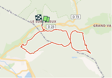
Trail Walking of 9.3 km to be discovered at Grand Est, Vosges, Ban-sur-Meurthe-Clefcy. This trail is proposed by surceneux.

Description

GASPARD  PORT DES PLANCHES CHARBONNIER VIA CASUETTE ET MILIEU SCHMALICK PORT DES PLANCHES LES BROCHES ALLEE BRIMBELLES TRAVERSE JDS SURCENEUX

Elevation profile

Positioning

Country:
France
Region :
Grand Est
Department/Province :
Vosges
Municipality :
Ban-sur-Meurthe-Clefcy
Location:
Unknown
Start:(UTM)
347802 ; 5328972 (32U) N.

Trails nearby

Trail Walking Le Valtin - Le Sentier des Roches - Photo
Walking
GUIDE
Michel1963

Walking

Difficult
(2)
Le Valtin, Grand Est, Vosges, France
20 km | 34 km-effort
7h 43min
Yes
Trail Walking Gérardmer - gerardmer - la mauselaine . tête grauvelin . Roche boquet . croix claudé . hautes Vannes . la mauselaine  - Photo
Walking
GUIDE
stef789

Walking

Very easy
(1)
Gérardmer, Grand Est, Vosges, France
11.3 km | 16.2 km-effort
3h 42min
Yes
Trail Walking La Bresse - Lac de Lispach et sentier Dielaine  - Photo
Walking
zazie

Walking

Medium
(1)
La Bresse, Grand Est, Vosges, France
9.7 km | 14.9 km-effort
2h 30min
Yes
Trail Walking Ban-sur-Meurthe-Clefcy - La vallée de Belbriette - Ban-sur-Meurthe-Clefcy - Photo
Walking
tracegps

Walking

Medium
(2)
Ban-sur-Meurthe-Clefcy, Grand Est, Vosges, France
9.8 km | 12.6 km-effort
2h 30min
Yes
Trail Walking Xonrupt-Longemer - 23-08-17 Lac Longemer - Lispach - Photo
Walking
annefrance70

Walking

Medium
(1)
Xonrupt-Longemer, Grand Est, Vosges, France
7 km | 12.1 km-effort
2h 13min
Yes
Trail Snowshoes Le Valtin - raquettes  - Photo
Snowshoes
vathi54

Snowshoes

Very easy
(1)
Le Valtin, Grand Est, Vosges, France
6.6 km | 9.4 km-effort
3h 8min
No
Trail Walking La Bresse - Lac de Lispach  - Photo
Walking
Bruca

Walking

Easy
(1)
La Bresse, Grand Est, Vosges, France
2.1 km | 2.4 km-effort
44min
Yes
Trail Walking Xonrupt-Longemer - Le Hohneck et le sentier des roches - Du lac de Longemer au lac de Schiessrothried - Photo
Walking
tracegps

Walking

Difficult
(1)
Xonrupt-Longemer, Grand Est, Vosges, France
15.7 km | 28 km-effort
7h 0min
No
Trail Snowshoes Xonrupt-Longemer - Tour du Lispach - Longemer - Photo
Snowshoes
tracegps

Snowshoes

Medium
(2)
Xonrupt-Longemer, Grand Est, Vosges, France
3.2 km | 6.6 km-effort
2h 0min
Yes


Close
My subscriptions