Trail Horseback riding Saint-Alban-sur-Limagnole - Boucle 1 Draille en Margeride - Photo

Boucle 1 Draille en Margeride

© OpenStreetMap contributors
Length
Length
120 km
Max alt
Max alt
1483 m
Uphill gradient
Uphill gradient
3079 m
Km-Effort
Km-Effort  
161 km
Min alt
Min alt
830 m
Downhill gradient
Downhill gradient
3031 m
Boucle
Boucle
No
Creation date :
2020-01-31 11:14:16.774
Updated on :
2020-11-24 09:58:46.813

(0 Reviews)

Horseback riding
Horseback riding
--
Difficulty : Very easy

Scan this QR Code to open this trail in the SityTrail application

FREE GPS app for hiking

Logo SityTrail SityTrail

IGN / Geographical institutes

Download SityTrail from the App Store Download SityTrail from Google Play

Logo SityTrail SityTrail World

The world is yours!

Download SityTrail from the App Store Download SityTrail from Google Play Download SityTrail on Huawei AppGallery

About

Trail Horseback riding of 120 km to be discovered at Occitania, Lozère, Saint-Alban-sur-Limagnole. This trail is proposed by Lozère Cheval.

Description

rajouter extension

Elevation profile

Points of interest

Point of interest Saint-Alban-sur-Limagnole - Gerard Baras - Photo
Lozère Cheval
SAINT-ALBAN-SUR-LIMAGNOLE 
Point of interest Saint-Alban-sur-Limagnole - Oustal de Parent - Photo
Lozère Cheval
SAINT-ALBAN-SUR-LIMAGNOLE 
Point of interest Le Malzieu-Forain - La Cavale du Malzieu - Randonneur équestre - Photo
Lozère Cheval
Point of interest Le Malzieu-Forain - Le Pré de l'Hiver - Photo
Lozère Cheval
LE MALZIEU-FORAIN 
Point of interest Chanaleilles - Le Sauvage Départ Randonnée - Photo
Lozère Cheval
Point of interest Paulhac-en-Margeride - Auberge le Bon Accueil - Photo
Lozère Cheval
PAULHAC-EN-MARGERIDE 
Point of interest Saint-Alban-sur-Limagnole - Refuge du Pélerin - Photo
Lozère Cheval
SAINT-ALBAN-SUR-LIMAGNOLE 
Point of interest Bel-Air-Val-d'Ance - L'EquiMargeride - Randonneur equestre - Photo
Lozère Cheval
BEL-AIR-VAL-D'ANCE 

Positioning

Country:
France
Region :
Occitania
Department/Province :
Lozère
Municipality :
Saint-Alban-sur-Limagnole
Location:
Unknown
Start:(UTM)
533518 ; 4961159 (31T) N.

Trails nearby

Trail Walking Chanaleilles - Le Sauvage - Les Estrets - Chemin de Compostelle - Photo
Walking
tracegps

Walking

Very difficult
(1)
Chanaleilles, Auvergne-Rhône-Alpes, Haute-Loire, France
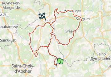
21 km | 27 km-effort
5h 4min
No
Trail Walking Lajo - La Roche Aumont Aubrac avril 2018 - Photo
Walking
GUIDE
Kargil

Walking

Difficult
Lajo, Occitania, Lozère, France
24 km | 31 km-effort
7h 39min
No
Trail Walking Sainte-Eulalie - circuit à Sainte Eulalie - Photo
Walking
GILOU440

Walking

Easy
Sainte-Eulalie, Occitania, Lozère, France
10.9 km | 14.4 km-effort
3h 16min
Yes
Trail Walking Saint-Alban-sur-Limagnole - DONNEPEAU - Photo
Walking
walrou63

Walking

Easy
Saint-Alban-sur-Limagnole, Occitania, Lozère, France
4.6 km | 6.5 km-effort
1h 24min
Yes
Trail Walking Saint-Alban-sur-Limagnole - LA LIMAGNOLE  - Photo
Walking
walrou63

Walking

Medium
Saint-Alban-sur-Limagnole, Occitania, Lozère, France
9.2 km | 13.4 km-effort
2h 57min
Yes
Trail Walking Chanaleilles - Le Sauvage - Aumont-Aubrac - Photo
Walking
RR31

Walking

Very difficult
Chanaleilles, Auvergne-Rhône-Alpes, Haute-Loire, France
31 km | 39 km-effort
8h 44min
No
Trail Walking Saint-Alban-sur-Limagnole - Étape 4 - Photo
Walking
countryside

Walking

Medium
Saint-Alban-sur-Limagnole, Occitania, Lozère, France
22 km | 28 km-effort
5h 29min
No
Trail Walking Saint-Alban-sur-Limagnole - Étape 4 - Photo
Walking
countryside

Walking

Medium
Saint-Alban-sur-Limagnole, Occitania, Lozère, France
22 km | 28 km-effort
5h 29min
No
Trail Walking Saint-Alban-sur-Limagnole - Les Faux - Aumont-Aubrac - Photo
Walking
countryside

Walking

Medium
Saint-Alban-sur-Limagnole, Occitania, Lozère, France
22 km | 28 km-effort
5h 57min
No


Close
My subscriptions