![](/images/other/stat-length.png)
![Trail Walking Bron - Bron Parilly 27 01 20 -6.6 a 72 g 0.5 d6 - Photo](https://media.geolcdn.com/t/1900/400/ext.pjpeg?maxdim=2&url=https%3A%2F%2Fstatic1.geolcdn.com%2Fsiteimages%2Fupload%2Ffiles%2F1553511878bg_sport_marche.png)
Bron Parilly 27 01 20 -6.6 a 72 g 0.5 d6
jtraverse
User
![Length](/images/other/stat-length.png)
Length
6.6 km
![Max alt](https://static1.geolcdn.com/siteimages/upload/files/1508320355ic_sort_altitude_max_24dp.png)
Max alt
217 m
![Uphill gradient](https://static1.geolcdn.com/siteimages/upload/files/1508320355ic_sort_den_pos_24dp.png)
Uphill gradient
72 m
![Km-Effort](/images/other/stat-length.png)
Km-Effort
7.6 km
![Min alt](https://static1.geolcdn.com/siteimages/upload/files/1508320355ic_sort_altitude_min_24dp.png)
Min alt
183 m
![Downhill gradient](https://static1.geolcdn.com/siteimages/upload/files/1508320355ic_sort_den_neg_24dp.png)
Downhill gradient
77 m
![Boucle](https://static1.geolcdn.com/siteimages/upload/files/16400158638029165_repeat_loop_refresh_sync_direction_icon.png)
Boucle
Yes
Creation date :
2020-01-28 12:52:01.065
Updated on :
2020-01-29 08:41:22.488
![Walking](https://static1.geolcdn.com/sitytour/trail-icons/101.png)
4h32
Difficulty : Very easy
![Scan this QR Code to open this trail in the SityTrail application](https://capi.geolives.com/qq0zvz2zws4bq2lad0pu/sitytour/trails/2317960/qr.png?size=200)
FREE GPS app for hiking
About
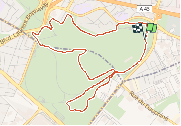
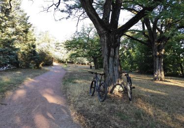
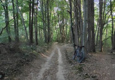
Trail Walking of 6.6 km to be discovered at Auvergne-Rhône-Alpes, Métropole de Lyon, Bron. This trail is proposed by jtraverse.
Description
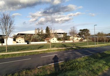
BRON - PARILLY Trajet voiture 6.0 km, 12 min
GPS Pk : 45.7226, 4.9135 ou 45°43'21.4"N 4°54'48.6"E
Adresse : Boulevard des Turfistes 69500 BRON
Positioning
Country:
France
Region :
Auvergne-Rhône-Alpes
Department/Province :
Métropole de Lyon
Municipality :
Bron
Location:
Unknown
Start:(Dec)
Start:(UTM)
648887 ; 5065069 (31T) N.
Comments
Trails nearby
![Trail Walking Lyon - 69-Lyon-murs-peints-musée-Tony-Garnier-mai21 - Photo](https://media.geolcdn.com/t/375/260/b5addc37-d1ea-430e-a818-e75353872d12.jpg&format=jpg&maxdim=2)
![Walking Walking](https://static1.geolcdn.com/sitytour/trail-icons/101.png)
69-Lyon-murs-peints-musée-Tony-Garnier-mai21
Walking
Easy
(1)
Lyon,
Auvergne-Rhône-Alpes,
Métropole de Lyon,
France
![](/images/other/stat-length.png)
3.7 km | 4 km-effort
1h 37min
![](https://static1.geolcdn.com/siteimages/upload/files/16400158638029165_repeat_loop_refresh_sync_direction_icon.png)
Yes
![Mountain bike Mountain bike](https://static1.geolcdn.com/sitytour/trail-icons/202.png)
Saint-Priest Cyclisme sur route
Mountain bike
Medium
(1)
Saint-Priest,
Auvergne-Rhône-Alpes,
Métropole de Lyon,
France
![](/images/other/stat-length.png)
24 km | 27 km-effort
1h 48min
![](https://static1.geolcdn.com/siteimages/upload/files/16400158638029165_repeat_loop_refresh_sync_direction_icon.png)
Yes
![Trail Walking Saint-Priest - 69-GR169-St-Priest-Meyzieu-21km-210m - Photo](https://media.geolcdn.com/t/375/260/8cb947a2-d107-4672-8e57-f897f73d677c.jpg&format=jpg&maxdim=2)
![Walking Walking](https://static1.geolcdn.com/sitytour/trail-icons/101.png)
69-GR169-St-Priest-Meyzieu-21km-210m
Walking
Difficult
Saint-Priest,
Auvergne-Rhône-Alpes,
Métropole de Lyon,
France
![](/images/other/stat-length.png)
21 km | 24 km-effort
4h 42min
![](https://static1.geolcdn.com/siteimages/upload/files/16400158638029165_repeat_loop_refresh_sync_direction_icon.png)
No
![Trail Hybrid bike Saint-Priest - VTT - Saint Priest Mairie au Parc de Parilly - Photo](https://media.geolcdn.com/t/375/260/09989568-30d4-4b05-9fc9-26c146c849b5.jpg&format=jpg&maxdim=2)
![Hybrid bike Hybrid bike](https://static1.geolcdn.com/sitytour/trail-icons/203.png)
VTT - Saint Priest Mairie au Parc de Parilly
Hybrid bike
Very easy
Saint-Priest,
Auvergne-Rhône-Alpes,
Métropole de Lyon,
France
![](/images/other/stat-length.png)
18.3 km | 20 km-effort
2h 0min
![](https://static1.geolcdn.com/siteimages/upload/files/16400158638029165_repeat_loop_refresh_sync_direction_icon.png)
Yes
![Trail Mountain bike Saint-Priest - VTT Saint Priest Vallencin Chaponnay - Photo](https://media.geolcdn.com/t/375/260/d692d4b8-f5ea-4cfa-9757-7fe9b85df7d8.jpg&format=jpg&maxdim=2)
![Mountain bike Mountain bike](https://static1.geolcdn.com/sitytour/trail-icons/202.png)
VTT Saint Priest Vallencin Chaponnay
Mountain bike
Very difficult
Saint-Priest,
Auvergne-Rhône-Alpes,
Métropole de Lyon,
France
![](/images/other/stat-length.png)
55 km | 67 km-effort
4h 26min
![](https://static1.geolcdn.com/siteimages/upload/files/16400158638029165_repeat_loop_refresh_sync_direction_icon.png)
Yes
![Trail Mountain bike Lyon - Mont Verdun - Photo](https://media.geolcdn.com/t/375/260/ext.jpg?maxdim=2&url=https%3A%2F%2Fstatic1.geolcdn.com%2Fsiteimages%2Fupload%2Ffiles%2F1524743154velo.jpg)
![Mountain bike Mountain bike](https://static1.geolcdn.com/sitytour/trail-icons/202.png)
Mont Verdun
Mountain bike
Difficult
(1)
Lyon,
Auvergne-Rhône-Alpes,
Métropole de Lyon,
France
![](/images/other/stat-length.png)
37 km | 47 km-effort
3h 18min
![](https://static1.geolcdn.com/siteimages/upload/files/16400158638029165_repeat_loop_refresh_sync_direction_icon.png)
No
![Trail Walking Lyon - Lyon 25-01-2014 - Photo](https://media.geolcdn.com/t/375/260/ext.jpg?maxdim=2&url=https%3A%2F%2Fservices.sitytrail.com%2FGeolivesWS%2FDownloadMedia.ashx%3FTrailID%3D244719%26Media%3Debb40e74-7703-4e60-b204-79a334b6f1d3.JPG)
![Walking Walking](https://static1.geolcdn.com/sitytour/trail-icons/101.png)
Lyon 25-01-2014
Walking
Very easy
Lyon,
Auvergne-Rhône-Alpes,
Métropole de Lyon,
France
![](/images/other/stat-length.png)
21 km | 26 km-effort
5h 31min
![](https://static1.geolcdn.com/siteimages/upload/files/16400158638029165_repeat_loop_refresh_sync_direction_icon.png)
Yes
![Trail Cycle Saint-Priest - St Priest - L'isle d'abeau Les 3 vallons - Photo](https://media.geolcdn.com/t/375/260/ext.jpg?maxdim=2&url=https%3A%2F%2Fstatic1.geolcdn.com%2Fsiteimages%2Fupload%2Ffiles%2F1524743154velo.jpg)
![Cycle Cycle](https://static1.geolcdn.com/sitytour/trail-icons/200.png)
St Priest - L'isle d'abeau Les 3 vallons
Cycle
Medium
(1)
Saint-Priest,
Auvergne-Rhône-Alpes,
Métropole de Lyon,
France
![](/images/other/stat-length.png)
34 km | 38 km-effort
1h 46min
![](https://static1.geolcdn.com/siteimages/upload/files/16400158638029165_repeat_loop_refresh_sync_direction_icon.png)
No
![Trail Mountain bike Saint-Priest - 69-vtt-StPriest-Decines-28km-280m - Photo](https://media.geolcdn.com/t/375/260/956a0250-e54b-463c-8a19-332eee865eda.jpg&format=jpg&maxdim=2)
![Mountain bike Mountain bike](https://static1.geolcdn.com/sitytour/trail-icons/202.png)
69-vtt-StPriest-Decines-28km-280m
Mountain bike
Medium
Saint-Priest,
Auvergne-Rhône-Alpes,
Métropole de Lyon,
France
![](/images/other/stat-length.png)
28 km | 31 km-effort
2h 34min
![](https://static1.geolcdn.com/siteimages/upload/files/16400158638029165_repeat_loop_refresh_sync_direction_icon.png)
Yes