![](/images/other/stat-length.png)
![Trail Solignac-sur-Loire - 2020-01-20_00h14m53_SityTrail - 191585 - de-grottes-en-cascades---solignac-sur-loire - Photo](https://media.geolcdn.com/t/1900/400/ext.pjpeg?maxdim=2&url=https%3A%2F%2Fsecurestorage.geolives.com%2Fsitytour%2Ftrail-bg%2Fdefault.jpg)
2020-01-20_00h14m53_SityTrail - 191585 - de-grottes-en-cascades---solignac-sur-loire
solignac43
User
![Length](/images/other/stat-length.png)
![Max alt](https://static1.geolcdn.com/siteimages/upload/files/1508320355ic_sort_altitude_max_24dp.png)
![Uphill gradient](https://static1.geolcdn.com/siteimages/upload/files/1508320355ic_sort_den_pos_24dp.png)
![Km-Effort](/images/other/stat-length.png)
![Min alt](https://static1.geolcdn.com/siteimages/upload/files/1508320355ic_sort_altitude_min_24dp.png)
![Downhill gradient](https://static1.geolcdn.com/siteimages/upload/files/1508320355ic_sort_den_neg_24dp.png)
![Boucle](https://static1.geolcdn.com/siteimages/upload/files/16400158638029165_repeat_loop_refresh_sync_direction_icon.png)
![Scan this QR Code to open this trail in the SityTrail application](https://capi.geolives.com/qq0zvz2zws4bq2lad0pu/sitytour/trails/2310514/qr.png?size=200)
FREE GPS app for hiking
About
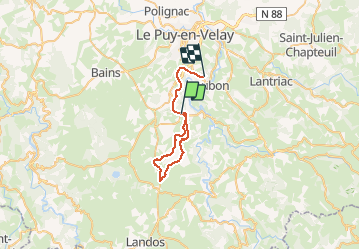
Trail of 30 km to be discovered at Auvergne-Rhône-Alpes, Haute-Loire, Solignac-sur-Loire. This trail is proposed by solignac43.
Description
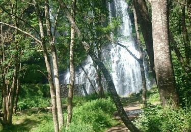
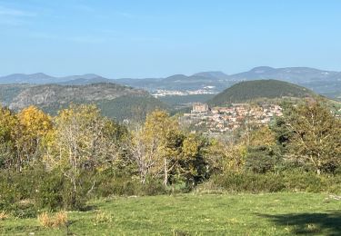
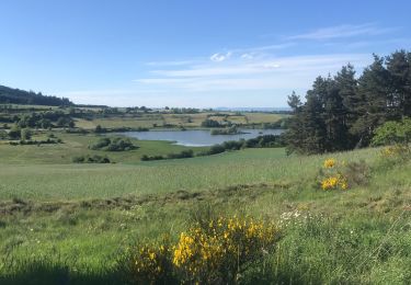
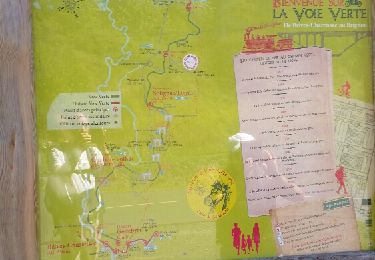
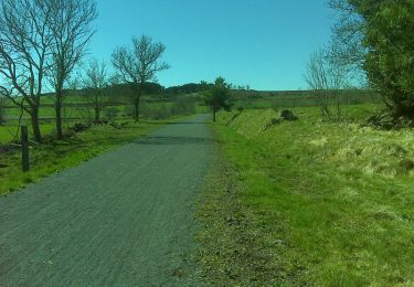
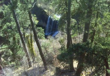
Belle boucle avec en première partie, la montée de la voie verte nouvellement ouverte dans le tronçon Solignac- Costaros. Cette partie de 10 km est sans surprise, roulante, bien entretenue et sans tunnel. On peut également partir de Brives-Charensac; de nombreux tunnels éclairés seront traversés sur un très beau parcours qui emprunte l'ancienne voie ferrée Le Puy- Langogne ( 23km aller) mais le retour est en descente constante. Le nouveau tronçon vous amène aux portes de Costaros. La 2ème partie de ce parcours présente une boucle plus variée qui permet de serpenter à travers champs, d'atteindre la vallée de la Beaume et sa cascade fort agréable. Admirez aussi l'église du Brignon en pleine rénovation. Retour sur Solignac par le goudron après un passage délicat dans la descente sur la Beaume. Si les muscles ont encore besoin de travailler, rejoindre la gare de Coubon (comme sur le tracé de 31 km) ou Brives mais il faut alors penser à descendre le véhicule de transport !
Positioning
Comments
Trails nearby
![Trail Walking Solignac-sur-Loire - cascade de la beaume haute loire - Photo](https://media.geolcdn.com/t/375/260/ec965890-39b5-4237-9849-2251ccda9c3d.jpg&format=jpg&maxdim=2)
![Walking Walking](https://static1.geolcdn.com/sitytour/trail-icons/101.png)
Walking
![](/images/other/stat-length.png)
![](https://static1.geolcdn.com/siteimages/upload/files/16400158638029165_repeat_loop_refresh_sync_direction_icon.png)
![Trail Mountain bike Solignac-sur-Loire - solignac goudet - Photo](https://media.geolcdn.com/t/375/260/ext.jpg?maxdim=2&url=https%3A%2F%2Fstatic1.geolcdn.com%2Fsiteimages%2Fupload%2Ffiles%2F1524743154velo.jpg)
![Mountain bike Mountain bike](https://static1.geolcdn.com/sitytour/trail-icons/202.png)
Mountain bike
![](/images/other/stat-length.png)
![](https://static1.geolcdn.com/siteimages/upload/files/16400158638029165_repeat_loop_refresh_sync_direction_icon.png)
![Trail Walking Coubon - Château de Lavalette circuit - Photo](https://media.geolcdn.com/t/375/260/02342f54-251d-4f7b-b32c-cdb9ddac92b9.jpg&format=jpg&maxdim=2)
![Walking Walking](https://static1.geolcdn.com/sitytour/trail-icons/101.png)
Walking
![](/images/other/stat-length.png)
![](https://static1.geolcdn.com/siteimages/upload/files/16400158638029165_repeat_loop_refresh_sync_direction_icon.png)
![Trail Walking Coubon - Stevenson 1+2 - Photo](https://media.geolcdn.com/t/375/260/a1d7896b-17f2-4e55-8df7-b5cdd434cbca.jpg&format=jpg&maxdim=2)
![Walking Walking](https://static1.geolcdn.com/sitytour/trail-icons/101.png)
Walking
![](/images/other/stat-length.png)
![](https://static1.geolcdn.com/siteimages/upload/files/16400158638029165_repeat_loop_refresh_sync_direction_icon.png)
![Trail Walking Cussac-sur-Loire - voie verte malpas costaros - Photo](https://media.geolcdn.com/t/375/260/ext.jpg?maxdim=2&url=https%3A%2F%2Fservices.sitytrail.com%2FGeolivesWS%2FDownloadMedia.ashx%3FTrailID%3D466027%26Media%3Dfix__20150830124156.jpg)
![Walking Walking](https://static1.geolcdn.com/sitytour/trail-icons/101.png)
Walking
![](/images/other/stat-length.png)
![](https://static1.geolcdn.com/siteimages/upload/files/16400158638029165_repeat_loop_refresh_sync_direction_icon.png)
![Trail Walking Coubon - GR70 Chemin de Stevenson Complet - Photo](https://media.geolcdn.com/t/375/260/ext.jpg?maxdim=2&url=https%3A%2F%2Fstatic1.geolcdn.com%2Fsiteimages%2Fupload%2Ffiles%2F1553511878bg_sport_marche.png)
![Walking Walking](https://static1.geolcdn.com/sitytour/trail-icons/101.png)
Walking
![](/images/other/stat-length.png)
![](https://static1.geolcdn.com/siteimages/upload/files/16400158638029165_repeat_loop_refresh_sync_direction_icon.png)
![Trail Mountain bike Solignac-sur-Loire - De grottes en cascades - Solignac-sur-Loire - Photo](https://media.geolcdn.com/t/375/260/ext.jpg?maxdim=2&url=https%3A%2F%2Fservices.sitytrail.com%2FGeolivesWS%2FDownloadMedia.ashx%3FTrailID%3D191585%26Media%3D15213_6.jpg)
![Mountain bike Mountain bike](https://static1.geolcdn.com/sitytour/trail-icons/202.png)
Mountain bike
![](/images/other/stat-length.png)
![](https://static1.geolcdn.com/siteimages/upload/files/16400158638029165_repeat_loop_refresh_sync_direction_icon.png)
![Trail Walking Solignac-sur-Loire - De grottes en cascades - Solignac-sur-Loire - Photo](https://media.geolcdn.com/t/375/260/ext.jpg?maxdim=2&url=https%3A%2F%2Fservices.sitytrail.com%2FGeolivesWS%2FDownloadMedia.ashx%3FTrailID%3D191584%26Media%3D15213_5.jpg)
![Walking Walking](https://static1.geolcdn.com/sitytour/trail-icons/101.png)
Walking
![](/images/other/stat-length.png)
![](https://static1.geolcdn.com/siteimages/upload/files/16400158638029165_repeat_loop_refresh_sync_direction_icon.png)
![Trail Walking Saint-Martin-de-Fugères - Source de Bonnefont - Photo](https://media.geolcdn.com/t/375/260/d5e8e22d-972f-42b6-9445-660f76b324ca.jpg&format=jpg&maxdim=2)
![Walking Walking](https://static1.geolcdn.com/sitytour/trail-icons/101.png)
Walking
![](/images/other/stat-length.png)
![](https://static1.geolcdn.com/siteimages/upload/files/16400158638029165_repeat_loop_refresh_sync_direction_icon.png)