


Sénégal IV 2ème Jour Tracé

Claude CHALMIN
User
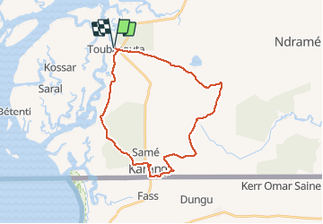

Length
80 km

Max alt
50 m

Uphill gradient
649 m
Km-Effort
88 km

Min alt
2 m

Downhill gradient
649 m
Boucle
Yes
Creation date :
2020-01-15 10:21:19.059
Updated on :
2020-01-15 18:23:59.425
6h40
Difficulty : Easy

FREE GPS app for hiking
 SityTrail
IGN / Geographical institutes
SityTrail World
The world is yours!
About
Trail Quad of 80 km to be discovered at Senegal. This trail is proposed by Claude CHALMIN.
Positioning
Country:
Senegal
Region :
Unknown
Department/Province :
Unknown
Municipality :
Unknown
Location:
Unknown
Start:(Dec)
Start:(UTM)
340369 ; 1524418 (28P) N.
Comments
Trails nearby