![](/images/other/stat-length.png)
![Trail Other activity Gossau (SG) - Grenzerfahrung - Photo](https://media.geolcdn.com/t/1900/400/ext.pjpeg?maxdim=2&url=https%3A%2F%2Fstatic1.geolcdn.com%2Fsiteimages%2Fupload%2Ffiles%2F1545311037marcheuse_200dpi.jpg)
Grenzerfahrung
merlot
User
![Length](/images/other/stat-length.png)
Length
30 km
![Max alt](https://static1.geolcdn.com/siteimages/upload/files/1508320355ic_sort_altitude_max_24dp.png)
Max alt
978 m
![Uphill gradient](https://static1.geolcdn.com/siteimages/upload/files/1508320355ic_sort_den_pos_24dp.png)
Uphill gradient
1362 m
![Km-Effort](/images/other/stat-length.png)
Km-Effort
49 km
![Min alt](https://static1.geolcdn.com/siteimages/upload/files/1508320355ic_sort_altitude_min_24dp.png)
Min alt
600 m
![Downhill gradient](https://static1.geolcdn.com/siteimages/upload/files/1508320355ic_sort_den_neg_24dp.png)
Downhill gradient
1366 m
![Boucle](https://static1.geolcdn.com/siteimages/upload/files/16400158638029165_repeat_loop_refresh_sync_direction_icon.png)
Boucle
Yes
Creation date :
2014-12-11 00:00:00.0
Updated on :
2014-12-11 00:00:00.0
![Other activity](https://static1.geolcdn.com/sitytour/trail-icons/900.png)
--
Difficulty : Unknown
![Scan this QR Code to open this trail in the SityTrail application](https://capi.geolives.com/qq0zvz2zws4bq2lad0pu/sitytour/trails/23046/qr.png?size=200)
FREE GPS app for hiking
About
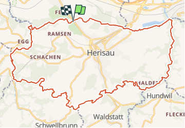
Trail Other activity of 30 km to be discovered at Sankt Gallen, Wahlkreis St. Gallen, Gossau (SG). This trail is proposed by merlot.
Description
Entlang der Gemeindegrenzen das Gemeindegebiet umwandern. max. Abweichung /-20 m
Positioning
Country:
Switzerland
Region :
Sankt Gallen
Department/Province :
Wahlkreis St. Gallen
Municipality :
Gossau (SG)
Location:
Unknown
Start:(Dec)
Start:(UTM)
519660 ; 5249659 (32T) N.
Comments
Trails nearby
![Trail Walking Hundwil - sf_e2a - Photo](https://media.geolcdn.com/t/375/260/ext.jpg?maxdim=2&url=https%3A%2F%2Fstatic1.geolcdn.com%2Fsiteimages%2Fupload%2Ffiles%2F1553511878bg_sport_marche.png)
![Walking Walking](https://static1.geolcdn.com/sitytour/trail-icons/101.png)
sf_e2a
Walking
Very easy
Hundwil,
Appenzell Ausserrhoden,
Hinterland,
Switzerland
![](/images/other/stat-length.png)
7.2 km | 14 km-effort
2h 26min
![](https://static1.geolcdn.com/siteimages/upload/files/16400158638029165_repeat_loop_refresh_sync_direction_icon.png)
No
![Trail Walking St. Gallen - sf1_e1a - Photo](https://media.geolcdn.com/t/375/260/ext.jpg?maxdim=2&url=https%3A%2F%2Fstatic1.geolcdn.com%2Fsiteimages%2Fupload%2Ffiles%2F1553511878bg_sport_marche.png)
![Walking Walking](https://static1.geolcdn.com/sitytour/trail-icons/101.png)
sf1_e1a
Walking
Very easy
St. Gallen,
Sankt Gallen,
Wahlkreis St. Gallen,
Switzerland
![](/images/other/stat-length.png)
4.9 km | 6.6 km-effort
1h 21min
![](https://static1.geolcdn.com/siteimages/upload/files/16400158638029165_repeat_loop_refresh_sync_direction_icon.png)
No
![Trail Other activity Herisau - Challenge09_T4 - Photo](https://media.geolcdn.com/t/375/260/ext.jpg?maxdim=2&url=https%3A%2F%2Fstatic1.geolcdn.com%2Fsiteimages%2Fupload%2Ffiles%2F1545311037marcheuse_200dpi.jpg)
![Other activity Other activity](https://static1.geolcdn.com/sitytour/trail-icons/900.png)
Challenge09_T4
Other activity
Very easy
Herisau,
Appenzell Ausserrhoden,
Hinterland,
Switzerland
![](/images/other/stat-length.png)
10.1 km | 14.7 km-effort
2h 36min
![](https://static1.geolcdn.com/siteimages/upload/files/16400158638029165_repeat_loop_refresh_sync_direction_icon.png)
No
![Trail Other activity Herisau - Nieschberg - Photo](https://media.geolcdn.com/t/375/260/ext.jpg?maxdim=2&url=https%3A%2F%2Fstatic1.geolcdn.com%2Fsiteimages%2Fupload%2Ffiles%2F1545311037marcheuse_200dpi.jpg)
![Other activity Other activity](https://static1.geolcdn.com/sitytour/trail-icons/900.png)
Nieschberg
Other activity
Very easy
Herisau,
Appenzell Ausserrhoden,
Hinterland,
Switzerland
![](/images/other/stat-length.png)
12 km | 17.2 km-effort
Unknown
![](https://static1.geolcdn.com/siteimages/upload/files/16400158638029165_repeat_loop_refresh_sync_direction_icon.png)
Yes
![Trail Other activity Gossau (SG) - Challenge_08_S5 - Photo](https://media.geolcdn.com/t/375/260/ext.jpg?maxdim=2&url=https%3A%2F%2Fstatic1.geolcdn.com%2Fsiteimages%2Fupload%2Ffiles%2F1545311037marcheuse_200dpi.jpg)
![Other activity Other activity](https://static1.geolcdn.com/sitytour/trail-icons/900.png)
Challenge_08_S5
Other activity
Very easy
Gossau (SG),
Sankt Gallen,
Wahlkreis St. Gallen,
Switzerland
![](/images/other/stat-length.png)
11.3 km | 16.4 km-effort
Unknown
![](https://static1.geolcdn.com/siteimages/upload/files/16400158638029165_repeat_loop_refresh_sync_direction_icon.png)
No
![Trail Other activity Flawil - Teilstrecke 4a - Photo](https://media.geolcdn.com/t/375/260/ext.jpg?maxdim=2&url=https%3A%2F%2Fstatic1.geolcdn.com%2Fsiteimages%2Fupload%2Ffiles%2F1545311037marcheuse_200dpi.jpg)
![Other activity Other activity](https://static1.geolcdn.com/sitytour/trail-icons/900.png)
Teilstrecke 4a
Other activity
Very easy
Flawil,
Sankt Gallen,
Wahlkreis Wil,
Switzerland
![](/images/other/stat-length.png)
3.2 km | 5.3 km-effort
Unknown
![](https://static1.geolcdn.com/siteimages/upload/files/16400158638029165_repeat_loop_refresh_sync_direction_icon.png)
No
![Trail Other activity Herisau - Kleines Voralpenbrevet - Photo](https://media.geolcdn.com/t/375/260/ext.jpg?maxdim=2&url=https%3A%2F%2Fstatic1.geolcdn.com%2Fsiteimages%2Fupload%2Ffiles%2F1545311037marcheuse_200dpi.jpg)
![Other activity Other activity](https://static1.geolcdn.com/sitytour/trail-icons/900.png)
Kleines Voralpenbrevet
Other activity
Very easy
Herisau,
Appenzell Ausserrhoden,
Hinterland,
Switzerland
![](/images/other/stat-length.png)
79 km | 104 km-effort
11h 25min
![](https://static1.geolcdn.com/siteimages/upload/files/16400158638029165_repeat_loop_refresh_sync_direction_icon.png)
Yes
![Trail Other activity Herisau - Teil Mitte/Oben - Photo](https://media.geolcdn.com/t/375/260/ext.jpg?maxdim=2&url=https%3A%2F%2Fstatic1.geolcdn.com%2Fsiteimages%2Fupload%2Ffiles%2F1545311037marcheuse_200dpi.jpg)
![Other activity Other activity](https://static1.geolcdn.com/sitytour/trail-icons/900.png)
Teil Mitte/Oben
Other activity
Very easy
Herisau,
Appenzell Ausserrhoden,
Hinterland,
Switzerland
![](/images/other/stat-length.png)
14.4 km | 22 km-effort
Unknown
![](https://static1.geolcdn.com/siteimages/upload/files/16400158638029165_repeat_loop_refresh_sync_direction_icon.png)
No
![Trail Other activity Gossau (SG) - Karte Nord-Ost - Photo](https://media.geolcdn.com/t/375/260/ext.jpg?maxdim=2&url=https%3A%2F%2Fstatic1.geolcdn.com%2Fsiteimages%2Fupload%2Ffiles%2F1545311037marcheuse_200dpi.jpg)
![Other activity Other activity](https://static1.geolcdn.com/sitytour/trail-icons/900.png)
Karte Nord-Ost
Other activity
Very easy
Gossau (SG),
Sankt Gallen,
Wahlkreis St. Gallen,
Switzerland
![](/images/other/stat-length.png)
24 km | 42 km-effort
Unknown
![](https://static1.geolcdn.com/siteimages/upload/files/16400158638029165_repeat_loop_refresh_sync_direction_icon.png)
Yes