![](/images/other/stat-length.png)
![Trail Walking Sainneville - Sainneville sur Seine / St Laurent de Brevedent / Sainneville sur Seine par le Héroboc - Photo](https://media.geolcdn.com/t/1900/400/d335de10-b191-4f77-8cff-c34ee176d2d5.jpg&format=pjpeg&maxdim=2)
Sainneville sur Seine / St Laurent de Brevedent / Sainneville sur Seine par le Héroboc
MarcherEnsemble
User
![Length](/images/other/stat-length.png)
Length
9.5 km
![Max alt](https://static1.geolcdn.com/siteimages/upload/files/1508320355ic_sort_altitude_max_24dp.png)
Max alt
120 m
![Uphill gradient](https://static1.geolcdn.com/siteimages/upload/files/1508320355ic_sort_den_pos_24dp.png)
Uphill gradient
83 m
![Km-Effort](/images/other/stat-length.png)
Km-Effort
10.6 km
![Min alt](https://static1.geolcdn.com/siteimages/upload/files/1508320355ic_sort_altitude_min_24dp.png)
Min alt
68 m
![Downhill gradient](https://static1.geolcdn.com/siteimages/upload/files/1508320355ic_sort_den_neg_24dp.png)
Downhill gradient
81 m
![Boucle](https://static1.geolcdn.com/siteimages/upload/files/16400158638029165_repeat_loop_refresh_sync_direction_icon.png)
Boucle
Yes
Creation date :
2020-01-13 08:14:49.694
Updated on :
2022-12-30 15:12:03.554
![Walking](https://static1.geolcdn.com/sitytour/trail-icons/101.png)
2h27
Difficulty : Very easy
![Scan this QR Code to open this trail in the SityTrail application](https://capi.geolives.com/qq0zvz2zws4bq2lad0pu/sitytour/trails/2304295/qr.png?size=200)
FREE GPS app for hiking
About
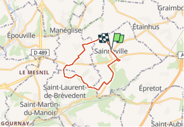
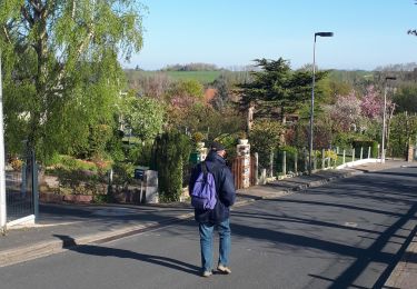
Trail Walking of 9.5 km to be discovered at Normandy, Seine-Maritime, Sainneville. This trail is proposed by MarcherEnsemble.
Description
Départ du parking de la salle des fêtes de Sainneville sur Seine où il y a toujours des places de stationnement.
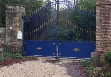
NE PAS SE GARER SUR LA PLACE DE LA MAIRIE svp
St Laurent de Brevedent par le Ronceret et le Héroboc.
Positioning
Country:
France
Region :
Normandy
Department/Province :
Seine-Maritime
Municipality :
Sainneville
Location:
Unknown
Start:(Dec)
Start:(UTM)
303794 ; 5492949 (31U) N.
Comments
Trails nearby
![Trail Walking Saint-Martin-du-Manoir - st Martin - st Laurent - Photo](https://media.geolcdn.com/t/375/260/ext.jpg?maxdim=2&url=https%3A%2F%2Fstatic1.geolcdn.com%2Fsiteimages%2Fupload%2Ffiles%2F1553511878bg_sport_marche.png)
![Walking Walking](https://static1.geolcdn.com/sitytour/trail-icons/101.png)
st Martin - st Laurent
Walking
Difficult
(1)
Saint-Martin-du-Manoir,
Normandy,
Seine-Maritime,
France
![](/images/other/stat-length.png)
10.6 km | 12.7 km-effort
2h 52min
![](https://static1.geolcdn.com/siteimages/upload/files/16400158638029165_repeat_loop_refresh_sync_direction_icon.png)
Yes
![Trail Walking Épouville - epouville 7,8 - Photo](https://media.geolcdn.com/t/375/260/ext.jpg?maxdim=2&url=https%3A%2F%2Fstatic1.geolcdn.com%2Fsiteimages%2Fupload%2Ffiles%2F1553511878bg_sport_marche.png)
![Walking Walking](https://static1.geolcdn.com/sitytour/trail-icons/101.png)
epouville 7,8
Walking
Medium
(1)
Épouville,
Normandy,
Seine-Maritime,
France
![](/images/other/stat-length.png)
7.8 km | 9.3 km-effort
2h 6min
![](https://static1.geolcdn.com/siteimages/upload/files/16400158638029165_repeat_loop_refresh_sync_direction_icon.png)
Yes
![Trail On foot Sainneville - Autour de Sainneville sur Seine - Photo](https://media.geolcdn.com/t/375/260/ext.jpg?maxdim=2&url=https%3A%2F%2Fstatic1.geolcdn.com%2Fsiteimages%2Fupload%2Ffiles%2F1545311037marcheuse_200dpi.jpg)
![On foot On foot](https://static1.geolcdn.com/sitytour/trail-icons/100.png)
Autour de Sainneville sur Seine
On foot
Easy
(1)
Sainneville,
Normandy,
Seine-Maritime,
France
![](/images/other/stat-length.png)
6.1 km | 6.7 km-effort
1h 31min
![](https://static1.geolcdn.com/siteimages/upload/files/16400158638029165_repeat_loop_refresh_sync_direction_icon.png)
Yes
![Trail Walking Gainneville - Tour de St Laurent de Brevedent variante N°3 - Photo](https://media.geolcdn.com/t/375/260/ext.jpg?maxdim=2&url=https%3A%2F%2Fstatic1.geolcdn.com%2Fsiteimages%2Fupload%2Ffiles%2F1553511878bg_sport_marche.png)
![Walking Walking](https://static1.geolcdn.com/sitytour/trail-icons/101.png)
Tour de St Laurent de Brevedent variante N°3
Walking
Very easy
(1)
Gainneville,
Normandy,
Seine-Maritime,
France
![](/images/other/stat-length.png)
10.4 km | 12.7 km-effort
2h 42min
![](https://static1.geolcdn.com/siteimages/upload/files/16400158638029165_repeat_loop_refresh_sync_direction_icon.png)
Yes
![Trail Walking Épouville - Epouville / Le Gray / La Lézarde /Epouville - Photo](https://media.geolcdn.com/t/375/260/ext.jpg?maxdim=2&url=https%3A%2F%2Fstatic1.geolcdn.com%2Fsiteimages%2Fupload%2Ffiles%2F1553511878bg_sport_marche.png)
![Walking Walking](https://static1.geolcdn.com/sitytour/trail-icons/101.png)
Epouville / Le Gray / La Lézarde /Epouville
Walking
Medium
(1)
Épouville,
Normandy,
Seine-Maritime,
France
![](/images/other/stat-length.png)
8.6 km | 10.3 km-effort
2h 20min
![](https://static1.geolcdn.com/siteimages/upload/files/16400158638029165_repeat_loop_refresh_sync_direction_icon.png)
Yes
![Trail Walking Étainhus - etainhus sur romain - Photo](https://media.geolcdn.com/t/375/260/41a320f0-00d5-4384-bb9e-c6b1373f691d.jpg&format=jpg&maxdim=2)
![Walking Walking](https://static1.geolcdn.com/sitytour/trail-icons/101.png)
etainhus sur romain
Walking
Medium
Étainhus,
Normandy,
Seine-Maritime,
France
![](/images/other/stat-length.png)
11.7 km | 13.4 km-effort
2h 53min
![](https://static1.geolcdn.com/siteimages/upload/files/16400158638029165_repeat_loop_refresh_sync_direction_icon.png)
Yes
![Trail Walking Saint-Laurent-de-Brèvedent - st Laurent revede.t - Photo](https://media.geolcdn.com/t/375/260/5097ace2-85a6-4fdb-9d65-32bd50b8dcf4.jpg&format=jpg&maxdim=2)
![Walking Walking](https://static1.geolcdn.com/sitytour/trail-icons/101.png)
st Laurent revede.t
Walking
Medium
Saint-Laurent-de-Brèvedent,
Normandy,
Seine-Maritime,
France
![](/images/other/stat-length.png)
13.1 km | 15.6 km-effort
3h 10min
![](https://static1.geolcdn.com/siteimages/upload/files/16400158638029165_repeat_loop_refresh_sync_direction_icon.png)
Yes
![Trail Walking Gainneville - Gainneville église / Gournay / St Martin / Gainneville église - Photo](https://media.geolcdn.com/t/375/260/f5ee4f8e-4f96-41e4-8426-318e8030de67.jpg&format=jpg&maxdim=2)
![Walking Walking](https://static1.geolcdn.com/sitytour/trail-icons/101.png)
Gainneville église / Gournay / St Martin / Gainneville église
Walking
Medium
Gainneville,
Normandy,
Seine-Maritime,
France
![](/images/other/stat-length.png)
9 km | 11.2 km-effort
2h 32min
![](https://static1.geolcdn.com/siteimages/upload/files/16400158638029165_repeat_loop_refresh_sync_direction_icon.png)
Yes
![Trail Walking Gainneville - Gainneville / St Aubin Routot / Rogerville / Gainneville - Photo](https://media.geolcdn.com/t/375/260/e6213cba-0906-484b-ac02-208fca0f82ee.jpg&format=jpg&maxdim=2)
![Walking Walking](https://static1.geolcdn.com/sitytour/trail-icons/101.png)
Gainneville / St Aubin Routot / Rogerville / Gainneville
Walking
Very easy
Gainneville,
Normandy,
Seine-Maritime,
France
![](/images/other/stat-length.png)
11.8 km | 13 km-effort
2h 41min
![](https://static1.geolcdn.com/siteimages/upload/files/16400158638029165_repeat_loop_refresh_sync_direction_icon.png)
Yes