![](/images/other/stat-length.png)
![Trail Walking Le Puy - Le Puy - Photo](https://media.geolcdn.com/t/1900/400/258f3f3c-c50b-405c-bd68-a6ac42ea325f.jpg&format=pjpeg&maxdim=2)
Le Puy
eltonnermou
User
![Length](/images/other/stat-length.png)
Length
14.1 km
![Max alt](https://static1.geolcdn.com/siteimages/upload/files/1508320355ic_sort_altitude_max_24dp.png)
Max alt
511 m
![Uphill gradient](https://static1.geolcdn.com/siteimages/upload/files/1508320355ic_sort_den_pos_24dp.png)
Uphill gradient
272 m
![Km-Effort](/images/other/stat-length.png)
Km-Effort
17.8 km
![Min alt](https://static1.geolcdn.com/siteimages/upload/files/1508320355ic_sort_altitude_min_24dp.png)
Min alt
319 m
![Downhill gradient](https://static1.geolcdn.com/siteimages/upload/files/1508320355ic_sort_den_neg_24dp.png)
Downhill gradient
273 m
![Boucle](https://static1.geolcdn.com/siteimages/upload/files/16400158638029165_repeat_loop_refresh_sync_direction_icon.png)
Boucle
Yes
Creation date :
2020-01-12 09:27:16.605
Updated on :
2020-01-12 20:06:43.917
![Walking](https://static1.geolcdn.com/sitytour/trail-icons/101.png)
2h08
Difficulty : Easy
![Scan this QR Code to open this trail in the SityTrail application](https://capi.geolives.com/qq0zvz2zws4bq2lad0pu/sitytour/trails/2303249/qr.png?size=200)
FREE GPS app for hiking
About
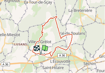
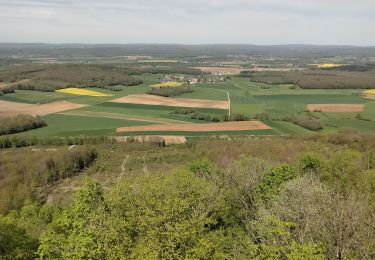
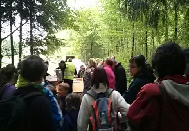
Trail Walking of 14.1 km to be discovered at Bourgogne-Franche-Comté, Doubs, Le Puy. This trail is proposed by eltonnermou.
Description
13,8km réel
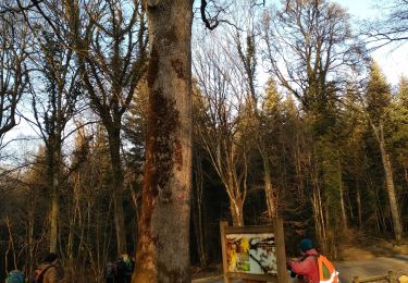
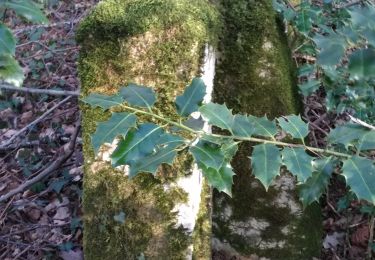
randonnée dans les bois entre Le Puy, Val de Roulans, en passant par le mont Bichoux Villers Grélot. On profite des éoliennes et de leur léger bruit.
Positioning
Country:
France
Region :
Bourgogne-Franche-Comté
Department/Province :
Doubs
Municipality :
Le Puy
Location:
Unknown
Start:(Dec)
Start:(UTM)
290659 ; 5247242 (32T) N.
Comments
Trails nearby
![Trail Walking Roulans - Roulans - Photo](https://media.geolcdn.com/t/375/260/2cbbd98c-ccf8-4bac-a479-dbed0aefef86.jpg&format=jpg&maxdim=2)
![Walking Walking](https://static1.geolcdn.com/sitytour/trail-icons/101.png)
Roulans
Walking
Very easy
(1)
Roulans,
Bourgogne-Franche-Comté,
Doubs,
France
![](/images/other/stat-length.png)
10.6 km | 13.7 km-effort
2h 44min
![](https://static1.geolcdn.com/siteimages/upload/files/16400158638029165_repeat_loop_refresh_sync_direction_icon.png)
Yes
![Trail Walking Ougney-Douvot - ougney la Roche (douvot) - Photo](https://media.geolcdn.com/t/375/260/532e6234-3db8-43f6-834f-754785112099.jpg&format=jpg&maxdim=2)
![Walking Walking](https://static1.geolcdn.com/sitytour/trail-icons/101.png)
ougney la Roche (douvot)
Walking
Easy
(1)
Ougney-Douvot,
Bourgogne-Franche-Comté,
Doubs,
France
![](/images/other/stat-length.png)
11.7 km | 16.9 km-effort
1h 54min
![](https://static1.geolcdn.com/siteimages/upload/files/16400158638029165_repeat_loop_refresh_sync_direction_icon.png)
Yes
![Trail Walking Séchin - Sechin 23 janvier 2020 CAF - Photo](https://media.geolcdn.com/t/375/260/9bdc166d-03a0-478f-a63a-eb5267e40a66.jpg&format=jpg&maxdim=2)
![Walking Walking](https://static1.geolcdn.com/sitytour/trail-icons/101.png)
Sechin 23 janvier 2020 CAF
Walking
Difficult
Séchin,
Bourgogne-Franche-Comté,
Doubs,
France
![](/images/other/stat-length.png)
19.5 km | 24 km-effort
6h 52min
![](https://static1.geolcdn.com/siteimages/upload/files/16400158638029165_repeat_loop_refresh_sync_direction_icon.png)
Yes
![Trail Walking La Tour-de-Sçay - tour de scay stade du moireau - Photo](https://media.geolcdn.com/t/375/260/425f68cd-6ed9-4219-9897-a8de90330dd1.jpg&format=jpg&maxdim=2)
![Walking Walking](https://static1.geolcdn.com/sitytour/trail-icons/101.png)
tour de scay stade du moireau
Walking
Medium
La Tour-de-Sçay,
Bourgogne-Franche-Comté,
Doubs,
France
![](/images/other/stat-length.png)
12.6 km | 17.5 km-effort
3h 37min
![](https://static1.geolcdn.com/siteimages/upload/files/16400158638029165_repeat_loop_refresh_sync_direction_icon.png)
Yes
![Trail Walking La Tour-de-Sçay - tour de scey stade - Photo](https://media.geolcdn.com/t/375/260/13803433-29dc-41a7-a887-aef065c694f5.jpg&format=jpg&maxdim=2)
![Walking Walking](https://static1.geolcdn.com/sitytour/trail-icons/101.png)
tour de scey stade
Walking
Medium
La Tour-de-Sçay,
Bourgogne-Franche-Comté,
Doubs,
France
![](/images/other/stat-length.png)
13.9 km | 19.9 km-effort
4h 41min
![](https://static1.geolcdn.com/siteimages/upload/files/16400158638029165_repeat_loop_refresh_sync_direction_icon.png)
Yes
![Trail Walking Marchaux-Chaudefontaine - Chaudfontaine 23-08-2020 - Photo](https://media.geolcdn.com/t/375/260/f085879d-0c4d-4fe3-b3a8-74270207b502.jpg&format=jpg&maxdim=2)
![Walking Walking](https://static1.geolcdn.com/sitytour/trail-icons/101.png)
Chaudfontaine 23-08-2020
Walking
Easy
Marchaux-Chaudefontaine,
Bourgogne-Franche-Comté,
Doubs,
France
![](/images/other/stat-length.png)
8.7 km | 11.8 km-effort
2h 38min
![](https://static1.geolcdn.com/siteimages/upload/files/16400158638029165_repeat_loop_refresh_sync_direction_icon.png)
Yes
![Trail Walking La Tour-de-Sçay - Le Verjoulot 6 fév 2020 CAF - Photo](https://media.geolcdn.com/t/375/260/51b02ae3-bb57-415c-815d-e0332d5118db.jpg&format=jpg&maxdim=2)
![Walking Walking](https://static1.geolcdn.com/sitytour/trail-icons/101.png)
Le Verjoulot 6 fév 2020 CAF
Walking
Very easy
La Tour-de-Sçay,
Bourgogne-Franche-Comté,
Doubs,
France
![](/images/other/stat-length.png)
19.4 km | 27 km-effort
6h 45min
![](https://static1.geolcdn.com/siteimages/upload/files/16400158638029165_repeat_loop_refresh_sync_direction_icon.png)
No
![Trail Walking Roulans - Comper 2013 - Photo](https://media.geolcdn.com/t/375/260/ext.jpg?maxdim=2&url=https%3A%2F%2Fservices.sitytrail.com%2FGeolivesWS%2FDownloadMedia.ashx%3FTrailID%3D195607%26Media%3D20130602091927.jpeg)
![Walking Walking](https://static1.geolcdn.com/sitytour/trail-icons/101.png)
Comper 2013
Walking
Easy
Roulans,
Bourgogne-Franche-Comté,
Doubs,
France
![](/images/other/stat-length.png)
10.3 km | 13.5 km-effort
3h 34min
![](https://static1.geolcdn.com/siteimages/upload/files/16400158638029165_repeat_loop_refresh_sync_direction_icon.png)
Yes
![Trail Walking La Tour-de-Sçay - rando tour de scey - Photo](https://media.geolcdn.com/t/375/260/ext.jpg?maxdim=2&url=https%3A%2F%2Fstatic1.geolcdn.com%2Fsiteimages%2Fupload%2Ffiles%2F1553511878bg_sport_marche.png)
![Walking Walking](https://static1.geolcdn.com/sitytour/trail-icons/101.png)
rando tour de scey
Walking
Difficult
La Tour-de-Sçay,
Bourgogne-Franche-Comté,
Doubs,
France
![](/images/other/stat-length.png)
12.9 km | 18.8 km-effort
5h 4min
![](https://static1.geolcdn.com/siteimages/upload/files/16400158638029165_repeat_loop_refresh_sync_direction_icon.png)
Yes