![](/images/other/stat-length.png)
![Trail On foot Arbonne-la-Forêt - 3 pignons : Boucle de la canche aux merciers - Photo](https://media.geolcdn.com/t/1900/400/06b5a776-ec23-4109-9f94-035e84e12559.jpg&format=pjpeg&maxdim=2)
3 pignons : Boucle de la canche aux merciers
jl77130
User
![Length](/images/other/stat-length.png)
Length
9.1 km
![Max alt](https://static1.geolcdn.com/siteimages/upload/files/1508320355ic_sort_altitude_max_24dp.png)
Max alt
124 m
![Uphill gradient](https://static1.geolcdn.com/siteimages/upload/files/1508320355ic_sort_den_pos_24dp.png)
Uphill gradient
133 m
![Km-Effort](/images/other/stat-length.png)
Km-Effort
10.9 km
![Min alt](https://static1.geolcdn.com/siteimages/upload/files/1508320355ic_sort_altitude_min_24dp.png)
Min alt
74 m
![Downhill gradient](https://static1.geolcdn.com/siteimages/upload/files/1508320355ic_sort_den_neg_24dp.png)
Downhill gradient
137 m
![Boucle](https://static1.geolcdn.com/siteimages/upload/files/16400158638029165_repeat_loop_refresh_sync_direction_icon.png)
Boucle
No
Creation date :
2020-01-11 13:00:48.0
Updated on :
2020-01-12 10:04:46.74
![On foot](https://static1.geolcdn.com/sitytour/trail-icons/100.png)
2h45
Difficulty : Easy
![Scan this QR Code to open this trail in the SityTrail application](https://capi.geolives.com/qq0zvz2zws4bq2lad0pu/sitytour/trails/2302528/qr.png?size=200)
FREE GPS app for hiking
About
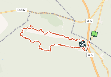
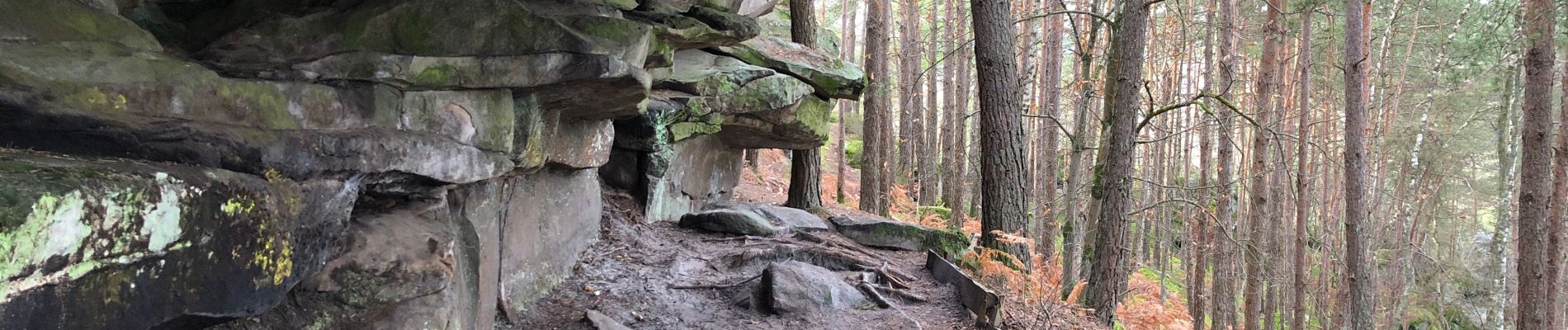
Trail On foot of 9.1 km to be discovered at Ile-de-France, Seine-et-Marne, Arbonne-la-Forêt. This trail is proposed by jl77130.
Description
Randonnée facile avec retour par versant nord et vue sur la partie nord du circuit des 25 bosses.
Départ au parking de la Canche aux Merciers puis suivre le circuit Dénecourt - Colinet couleur bleue N°16
Positioning
Country:
France
Region :
Ile-de-France
Department/Province :
Seine-et-Marne
Municipality :
Arbonne-la-Forêt
Location:
Unknown
Start:(Dec)
Start:(UTM)
467102 ; 5360211 (31U) N.
Comments
Trails nearby
![Trail Walking Le Vaudoué - Ultra 25 bosses - Photo](https://media.geolcdn.com/t/375/260/ext.jpg?maxdim=2&url=https%3A%2F%2Fservices.sitytrail.com%2FGeolivesWS%2FDownloadMedia.ashx%3FTrailID%3D243413%26Media%3Dfix__20140112104549.jpg)
![Walking Walking](https://static1.geolcdn.com/sitytour/trail-icons/101.png)
Ultra 25 bosses
Walking
Difficult
(1)
Le Vaudoué,
Ile-de-France,
Seine-et-Marne,
France
![](/images/other/stat-length.png)
25 km | 32 km-effort
9h 2min
![](https://static1.geolcdn.com/siteimages/upload/files/16400158638029165_repeat_loop_refresh_sync_direction_icon.png)
Yes
![Trail Walking Noisy-sur-École - M&R-121118 - 250Marches - Photo](https://media.geolcdn.com/t/375/260/ext.jpg?maxdim=2&url=https%3A%2F%2Fservices.sitytrail.com%2FGeolivesWS%2FDownloadMedia.ashx%3FTrailID%3D163348%26Media%3D20121118101634.jpeg)
![Walking Walking](https://static1.geolcdn.com/sitytour/trail-icons/101.png)
M&R-121118 - 250Marches
Walking
Easy
(1)
Noisy-sur-École,
Ile-de-France,
Seine-et-Marne,
France
![](/images/other/stat-length.png)
14.3 km | 18.1 km-effort
3h 50min
![](https://static1.geolcdn.com/siteimages/upload/files/16400158638029165_repeat_loop_refresh_sync_direction_icon.png)
Yes
![Trail Walking Milly-la-Forêt - Du parking de la Boulignère aux 100 marches via la ferme des Coquibus - Photo](https://media.geolcdn.com/t/375/260/2d4021ff-70a8-48ff-ad65-d6df60ccba59.jpg&format=jpg&maxdim=2)
![Walking Walking](https://static1.geolcdn.com/sitytour/trail-icons/101.png)
Du parking de la Boulignère aux 100 marches via la ferme des Coquibus
Walking
Difficult
(1)
Milly-la-Forêt,
Ile-de-France,
Essonne,
France
![](/images/other/stat-length.png)
18.3 km | 22 km-effort
5h 0min
![](https://static1.geolcdn.com/siteimages/upload/files/16400158638029165_repeat_loop_refresh_sync_direction_icon.png)
Yes
![Trail Walking Noisy-sur-École - Bois Rond#4 - Photo](https://media.geolcdn.com/t/375/260/7321184d-880d-445f-98b4-47f0ff0d82dd.jpg&format=jpg&maxdim=2)
![Walking Walking](https://static1.geolcdn.com/sitytour/trail-icons/101.png)
Bois Rond#4
Walking
Very easy
(1)
Noisy-sur-École,
Ile-de-France,
Seine-et-Marne,
France
![](/images/other/stat-length.png)
8.8 km | 10.5 km-effort
2h 18min
![](https://static1.geolcdn.com/siteimages/upload/files/16400158638029165_repeat_loop_refresh_sync_direction_icon.png)
Yes
![Trail Walking Noisy-sur-École - Les 25 Bosses - Gps en Forêt de Fontainebleau - Photo](https://media.geolcdn.com/t/375/260/ext.jpg?maxdim=2&url=https%3A%2F%2Fservices.sitytrail.com%2FGeolivesWS%2FDownloadMedia.ashx%3FTrailID%3D101528%26Media%3D1630_1.jpg)
![Walking Walking](https://static1.geolcdn.com/sitytour/trail-icons/101.png)
Les 25 Bosses - Gps en Forêt de Fontainebleau
Walking
Very difficult
(2)
Noisy-sur-École,
Ile-de-France,
Seine-et-Marne,
France
![](/images/other/stat-length.png)
17.6 km | 23 km-effort
4h 45min
![](https://static1.geolcdn.com/siteimages/upload/files/16400158638029165_repeat_loop_refresh_sync_direction_icon.png)
Yes
![Trail On foot Le Vaudoué - Boucle Le Vaudoué - Photo](https://media.geolcdn.com/t/375/260/d05a3ec5-b137-48e5-a689-019375766e60.jpg&format=jpg&maxdim=2)
![On foot On foot](https://static1.geolcdn.com/sitytour/trail-icons/100.png)
Boucle Le Vaudoué
On foot
Medium
Le Vaudoué,
Ile-de-France,
Seine-et-Marne,
France
![](/images/other/stat-length.png)
17.4 km | 21 km-effort
4h 47min
![](https://static1.geolcdn.com/siteimages/upload/files/16400158638029165_repeat_loop_refresh_sync_direction_icon.png)
Yes
![Trail Walking Noisy-sur-École - Boucle 24 km Fontainebleau Arbonne - Photo](https://media.geolcdn.com/t/375/260/5aaa62f0-dc57-4770-a77a-231413885a94.jpg&format=jpg&maxdim=2)
![Walking Walking](https://static1.geolcdn.com/sitytour/trail-icons/101.png)
Boucle 24 km Fontainebleau Arbonne
Walking
Easy
Noisy-sur-École,
Ile-de-France,
Seine-et-Marne,
France
![](/images/other/stat-length.png)
25 km | 31 km-effort
5h 52min
![](https://static1.geolcdn.com/siteimages/upload/files/16400158638029165_repeat_loop_refresh_sync_direction_icon.png)
Yes
![Trail Walking Noisy-sur-École - Noisy sur Ecole / Coquibus - Photo](https://media.geolcdn.com/t/375/260/9f6ffc55-2cbc-4988-8e49-be93fd15ba38.jpg&format=jpg&maxdim=2)
![Walking Walking](https://static1.geolcdn.com/sitytour/trail-icons/101.png)
Noisy sur Ecole / Coquibus
Walking
Medium
Noisy-sur-École,
Ile-de-France,
Seine-et-Marne,
France
![](/images/other/stat-length.png)
21 km | 26 km-effort
5h 20min
![](https://static1.geolcdn.com/siteimages/upload/files/16400158638029165_repeat_loop_refresh_sync_direction_icon.png)
Yes
![Trail Walking Noisy-sur-École - le-circuit-des-25-bosses-fontainebleau - Photo](https://media.geolcdn.com/t/375/260/ext.jpg?maxdim=2&url=https%3A%2F%2Fstatic1.geolcdn.com%2Fsiteimages%2Fupload%2Ffiles%2F1553511878bg_sport_marche.png)
![Walking Walking](https://static1.geolcdn.com/sitytour/trail-icons/101.png)
le-circuit-des-25-bosses-fontainebleau
Walking
Very difficult
(1)
Noisy-sur-École,
Ile-de-France,
Seine-et-Marne,
France
![](/images/other/stat-length.png)
17.6 km | 23 km-effort
5h 17min
![](https://static1.geolcdn.com/siteimages/upload/files/16400158638029165_repeat_loop_refresh_sync_direction_icon.png)
Yes