Trail Walking Rosheim - 67 Boucle Rosheim St Nabor Rosheim - Photo

67 Boucle Rosheim St Nabor Rosheim

 LUTZMarc
LUTZMarc

User

© OpenStreetMap contributors
Length
Length
34 km
Max alt
Max alt
367 m
Uphill gradient
Uphill gradient
457 m
Km-Effort
Km-Effort  
40 km
Min alt
Min alt
157 m
Downhill gradient
Downhill gradient
459 m
Boucle
Boucle
No
Creation date :
2020-01-09 07:58:06.913
Updated on :
2020-01-09 16:37:50.003

(0 Reviews)

Walking
Walking
5h12
Difficulty : Easy

Scan this QR Code to open this trail in the SityTrail application

FREE GPS app for hiking

Logo SityTrail SityTrail

IGN / Geographical institutes

Download SityTrail from the App Store Download SityTrail from Google Play

Logo SityTrail SityTrail World

The world is yours!

Download SityTrail from the App Store Download SityTrail from Google Play Download SityTrail on Huawei AppGallery

About

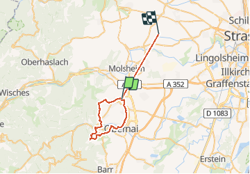
Trail Walking of 34 km to be discovered at Grand Est, Bas-Rhin, Rosheim. This trail is proposed by LUTZMarc.

Description

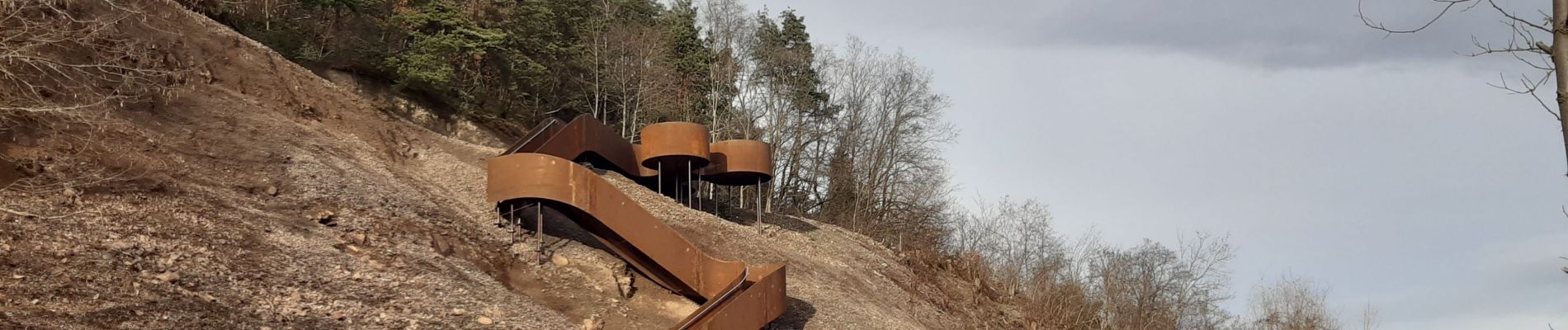
Rando sans difficulté. Beau point de vue au belvédère de la carrière de St Nabor. Au km 14  Resto recommandé au Rouge d'Ottrott. Il est préférable de réserver .

Elevation profile

Photos

Positioning

Country:
France
Region :
Grand Est
Department/Province :
Bas-Rhin
Municipality :
Rosheim
Location:
Unknown
Start:(UTM)
387932 ; 5373114 (32U) N.

Trails nearby

Trail Walking Mutzig - Les sanctuaires autour de Mutzig - Photo
Walking
VacheKiri67

Walking

Medium
(1)
Mutzig, Grand Est, Bas-Rhin, France
13.6 km | 17.9 km-effort
5h 0min
Yes
Trail Walking Ottrott - Le Mont Sainte-Odile depuis Otrott - Photo
Walking
VacheKiri67

Walking

Medium
(1)
Ottrott, Grand Est, Bas-Rhin, France
13 km | 20 km-effort
6h 18min
Yes
Trail Walking Mutzig - Les sanctuaires autour de Mutzig - Photo
Walking
tracegps

Walking

Difficult
(1)
Mutzig, Grand Est, Bas-Rhin, France
12.7 km | 16.8 km-effort
4h 0min
Yes
Trail Walking Dorlisheim - Escapade dans le vignoble de Dorlisheim - Photo
Walking
tracegps

Walking

Medium
(1)
Dorlisheim, Grand Est, Bas-Rhin, France
9.7 km | 12.6 km-effort
3h 0min
Yes
Trail Walking Mutzig - Autour du Fort de Mutzig - Photo
Walking
VacheKiri67

Walking

Difficult
(2)
Mutzig, Grand Est, Bas-Rhin, France
18.7 km | 26 km-effort
6h 30min
Yes
Trail Walking Obernai - Obernai gare - Mont St Odile - Photo
Walking
tracegps

Walking

Difficult
(2)
Obernai, Grand Est, Bas-Rhin, France
20 km | 29 km-effort
5h 0min
Yes
Trail Mountain bike Dinsheim-sur-Bruche - Les Grandes Manoeuvres - Photo
Mountain bike
tracegps

Mountain bike

Very difficult
(1)
Dinsheim-sur-Bruche, Grand Est, Bas-Rhin, France
45 km | 59 km-effort
4h 0min
Yes
Trail Mountain bike Ottrott - Sainte-Odile East-Face - Photo
Mountain bike
tracegps

Mountain bike

Difficult
(1)
Ottrott, Grand Est, Bas-Rhin, France
24 km | 39 km-effort
3h 0min
Yes
Trail Horseback riding Gresswiller - 2023-11-19 Picnic CVA Les pelouses du Jesselsberg - Photo
Horseback riding
GUIDE
holtzv

Horseback riding

Easy
Gresswiller, Grand Est, Bas-Rhin, France
28 km | 36 km-effort
4h 45min
Yes


Close
My subscriptions