Trail Walking Périgueux - Périgueux - St. Jean Pied de Port (GR 654 par Bergerac) - Photo

Périgueux - St. Jean Pied de Port (GR 654 par Bergerac)

On ne s'arrête pas parce qu'on vieillit, ... on vieillit parce qu'on s'arrête !

© OpenStreetMap contributors
Length
Length
410 km
Boucle
Boucle
No
Creation date :
2020-01-06 23:06:05.152
Updated on :
2020-01-31 11:51:00.396

(0 Reviews)

Walking
Walking
--
Difficulty : Very easy

Scan this QR Code to open this trail in the SityTrail application

FREE GPS app for hiking

Logo SityTrail SityTrail

IGN / Geographical institutes

Download SityTrail from the App Store Download SityTrail from Google Play

Logo SityTrail SityTrail World

The world is yours!

Download SityTrail from the App Store Download SityTrail from Google Play Download SityTrail on Huawei AppGallery

About

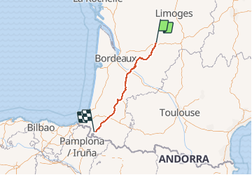
Trail Walking of 410 km to be discovered at New Aquitaine, Dordogne, Périgueux. This trail is proposed by HEKABI.

Description

GR 654 puis GR 65 conforme au topo de la Fédé. (pointé le 7/1/20)

Elevation profile

Points of interest

Point of interest Eynesse - MMDD T39/TOPO P10 - Photo
ABICHE
Point of interest Saint-André-et-Appelles - TOPO P11 - Photo
ABICHE
SAINT-ANDRÉ-ET-APPELLES 
Point of interest Les Lèves-et-Thoumeyragues - Lepère P232 - Photo
ABICHE
LES LÈVES-ET-THOUMEYRAGUES 
Point of interest Les Lèves-et-Thoumeyragues - TOPO P11 - Photo
ABICHE
LES LÈVES-ET-THOUMEYRAGUES 
Point of interest Saint-Quentin-de-Caplong - MMDD T40 - Photo
ABICHE
SAINT-QUENTIN-DE-CAPLONG 
Point of interest Saint-Quentin-de-Caplong - MMDD T40 - Photo
ABICHE
SAINT-QUENTIN-DE-CAPLONG 
Point of interest Saint-Quentin-de-Caplong - MMDD T40 - Photo
ABICHE
SAINT-QUENTIN-DE-CAPLONG 
Point of interest Massugas - TOPO P11 - Photo
ABICHE
MASSUGAS 
Point of interest Saint-Ferme - MMDD T42/Lepère P232 - Photo
ABICHE
Point of interest Le Puy - Q01 - Photo
ABICHE
LE PUY 
Point of interest Le Puy - Q01 - Photo
ABICHE
LE PUY 
Point of interest Coutures - MMDD T43 - Photo
ABICHE
COUTURES 
Point of interest Saint-Sulpice-de-Guilleragues - Q02 - Photo
ABICHE
SAINT-SULPICE-DE-GUILLERAGUES 
Point of interest Saint-Hilaire-de-la-Noaille - Q03 - Photo
ABICHE
SAINT-HILAIRE-DE-LA-NOAILLE 
Point of interest Saint-Hilaire-de-la-Noaille - MMDD T44/TOPO P11/Lepère P237 - Photo
ABICHE
SAINT-HILAIRE-DE-LA-NOAILLE 
Point of interest Saint-Hilaire-de-la-Noaille - MMDD T44/Lepère P237 - Photo
ABICHE
SAINT-HILAIRE-DE-LA-NOAILLE 
Point of interest Saint-Hilaire-de-la-Noaille - Q04  - Photo
ABICHE
SAINT-HILAIRE-DE-LA-NOAILLE 
Point of interest Floudès - Q05 - Photo
ABICHE
FLOUDÈS 
Point of interest Pondaurat - Q06 - Photo
ABICHE
PONDAURAT 
Point of interest Pondaurat - TOPO P11/Lepère P241 - Photo
ABICHE
Point of interest Savignac - Q07 - Photo
ABICHE
SAVIGNAC 
Point of interest Savignac - Q08 - Photo
ABICHE
SAVIGNAC 
Point of interest Auros - Q09 - Photo
ABICHE
AUROS 
Point of interest Auros - Q10 - Photo
ABICHE
AUROS 
Point of interest Cudos - MMDD T49 - Photo
ABICHE
CUDOS 
Point of interest Cudos - TOPO P12 - Photo
ABICHE
CUDOS 
Point of interest Bernos-Beaulac - MMDD T49/TOPO P12/Lepère P247 - Photo
ABICHE
Point of interest Bourriot-Bergonce - MMDD T53/TOPO P12/Lepère P253 - Photo
ABICHE
Point of interest Roquefort - Q13 - Photo
ABICHE
ROQUEFORT 
Point of interest Mont-de-Marsan - Refuge Asso. St. Jacques  des Landes (MMDD T58/TOPO P12/Lepère P261) - Photo
ABICHE
Point of interest Audignon - MMDD T61 - Photo
ABICHE
AUDIGNON 
Point of interest Audignon - MMDD T61 - Photo
ABICHE
AUDIGNON 
Point of interest Horsarrieu - MMDD T62 - Photo
ABICHE
HORSARRIEU 
Point of interest Hagetmau - MMDD T63 - Photo
ABICHE
HAGETMAU 
Point of interest Labastide-Chalosse - TOPO P13 - Photo
ABICHE
LABASTIDE-CHALOSSE 
Point of interest Sault-de-Navailles - MMDD T64 - Photo
ABICHE
SAULT-DE-NAVAILLES 
Point of interest Sault-de-Navailles - TOPO P13 - Photo
ABICHE
SAULT-DE-NAVAILLES 
Point of interest Sallespisse - MMDD T65 - Photo
ABICHE
SALLESPISSE 
Point of interest L'Hôpital-d'Orion - Q15 - Photo
ABICHE
L'HÔPITAL-D'ORION 
Point of interest L'Hôpital-d'Orion - MMDD T68 - Photo
ABICHE
L'HÔPITAL-D'ORION 
Point of interest Ozenx-Montestrucq - MMDD T67/TOPO P13/Lepère P282 - Photo
ABICHE
Point of interest L'Hôpital-d'Orion - Q16 - Photo
ABICHE
L'HÔPITAL-D'ORION 
Point of interest Andrein - TOPO P13 - Photo
ABICHE
ANDREIN 
Point of interest Sauveterre-de-Béarn - MMDD T69/TOPO P13/Lepère P283 - Photo
ABICHE
SAUVETERRE-DE-BÉARN 
Point of interest Sauveterre-de-Béarn - Q18 - Photo
ABICHE
SAUVETERRE-DE-BÉARN 
Point of interest Guinarthe-Parenties - Accueil pèlerin (MMDD T69/TOPO P13/Lepère P287) - Photo
ABICHE
GUINARTHE-PARENTIES 
Point of interest Osserain-Rivareyte - MMDD T69/TOPO P13/Lepère P287 - Photo
ABICHE
OSSERAIN-RIVAREYTE 
Point of interest Osserain-Rivareyte - Q19 - Photo
ABICHE
OSSERAIN-RIVAREYTE 
Point of interest Arbouet-Sussaute - MMDD T70 - Photo
ABICHE
ARBOUET-SUSSAUTE 
Point of interest Arbouet-Sussaute - Q21 - Photo
ABICHE
ARBOUET-SUSSAUTE 
Point of interest Arbouet-Sussaute - Q20 - Photo
ABICHE
ARBOUET-SUSSAUTE 
Point of interest Aïcirits-Camou-Suhast - MMDD T70/TOPO P14 - Photo
ABICHE
AÏCIRITS-CAMOU-SUHAST 
Point of interest Aïcirits-Camou-Suhast - Q23 - Photo
ABICHE
AÏCIRITS-CAMOU-SUHAST 
Point of interest Ostabat-Asme - MMDD T71 - Photo
ABICHE
OSTABAT-ASME 
Point of interest Juxue - MMDD T72 - Photo
ABICHE
JUXUE 
Point of interest Larceveau-Arros-Cibits - MMDD T72/TOPO P14 - Photo
ABICHE
LARCEVEAU-ARROS-CIBITS 
Point of interest Larceveau-Arros-Cibits - MMDD T73 - Photo
ABICHE
LARCEVEAU-ARROS-CIBITS 
Point of interest Ainhice-Mongelos - MMDD T73 - Photo
ABICHE
AINHICE-MONGELOS 
Point of interest Lacarre - MMDD T74 - Photo
ABICHE
LACARRE 
Point of interest Bussunarits-Sarrasquette - MMDD T74 - Photo
ABICHE
BUSSUNARITS-SARRASQUETTE 
Point of interest Saint-Jean-le-Vieux - MMDD T74/Topo P14 - Photo
ABICHE
SAINT-JEAN-LE-VIEUX 
Point of interest Saint-Jean-le-Vieux - MMDD T74 - Photo
ABICHE
SAINT-JEAN-LE-VIEUX 

Positioning

Country:
France
Region :
New Aquitaine
Department/Province :
Dordogne
Municipality :
Périgueux
Location:
Unknown
Start:(UTM)
320153 ; 5006367 (31T) N.

Trails nearby

Trail Walking Boulazac Isle Manoire - Boulazac à partir du Palio - Photo
Walking
tracegps

Walking

Medium
(1)
Boulazac Isle Manoire, New Aquitaine, Dordogne, France
7.3 km | 9 km-effort
1h 45min
Yes
Trail Walking Boulazac Isle Manoire - Octobre rose Boulazac 2022 - Photo
Walking
swp648

Walking

Easy
Boulazac Isle Manoire, New Aquitaine, Dordogne, France
7.7 km | 8.9 km-effort
1h 42min
Yes
Trail Walking Champcevinel - champcevinel - Photo
Walking
NICOLEROBERT

Walking

Difficult
Champcevinel, New Aquitaine, Dordogne, France
9.7 km | 12.3 km-effort
2h 48min
Yes
Trail Walking Chancelade - Circuit de l'Abbaye de Chancelade - Photo
Walking
CC.RIDER

Walking

Difficult
Chancelade, New Aquitaine, Dordogne, France
12.8 km | 18.3 km-effort
4h 9min
Yes
Trail Walking Chancelade - Boucle des Andrivaux - Photo
Walking
CC.RIDER

Walking

Very difficult
Chancelade, New Aquitaine, Dordogne, France
14.8 km | 19.3 km-effort
4h 23min
Yes
Trail Running Périgueux - jour 24 CAP Jeanot - Photo
Running
jeannat

Running

Very easy
Périgueux, New Aquitaine, Dordogne, France
21 km | 23 km-effort
3h 24min
No
Trail Walking Périgueux - Flânerie Périgueux  - Photo
Walking
rigol05

Walking

Medium
Périgueux, New Aquitaine, Dordogne, France
5.5 km | 6.5 km-effort
1h 55min
Yes
Trail On foot Boulazac Isle Manoire - Boulazac Lesparat  - Photo
On foot
audier

On foot

Easy
Boulazac Isle Manoire, New Aquitaine, Dordogne, France
10.6 km | 12.6 km-effort
2h 52min
Yes
Trail Walking Marsac-sur-l'Isle - Marsac - Photo
Walking
NICOLEROBERT

Walking

Easy
Marsac-sur-l'Isle, New Aquitaine, Dordogne, France
9.2 km | 11 km-effort
2h 29min
Yes


Close
My subscriptions