![](/images/other/stat-length.png)
![Trail Walking Maasmechelen - Peerkepad rondwandeling 3 - 14km. - Photo](https://media.geolcdn.com/t/1900/400/ext.pjpeg?maxdim=2&url=https%3A%2F%2Fstatic1.geolcdn.com%2Fsiteimages%2Fupload%2Ffiles%2F1553511878bg_sport_marche.png)
Peerkepad rondwandeling 3 - 14km.
flip96
User
![Length](/images/other/stat-length.png)
Length
14.2 km
![Max alt](https://static1.geolcdn.com/siteimages/upload/files/1508320355ic_sort_altitude_max_24dp.png)
Max alt
47 m
![Uphill gradient](https://static1.geolcdn.com/siteimages/upload/files/1508320355ic_sort_den_pos_24dp.png)
Uphill gradient
76 m
![Km-Effort](/images/other/stat-length.png)
Km-Effort
15.2 km
![Min alt](https://static1.geolcdn.com/siteimages/upload/files/1508320355ic_sort_altitude_min_24dp.png)
Min alt
27 m
![Downhill gradient](https://static1.geolcdn.com/siteimages/upload/files/1508320355ic_sort_den_neg_24dp.png)
Downhill gradient
78 m
![Boucle](https://static1.geolcdn.com/siteimages/upload/files/16400158638029165_repeat_loop_refresh_sync_direction_icon.png)
Boucle
Yes
Creation date :
2020-01-05 10:36:53.441
Updated on :
2020-01-05 10:38:43.556
![Walking](https://static1.geolcdn.com/sitytour/trail-icons/101.png)
3h23
Difficulty : Difficult
![Scan this QR Code to open this trail in the SityTrail application](https://capi.geolives.com/qq0zvz2zws4bq2lad0pu/sitytour/trails/2297367/qr.png?size=200)
FREE GPS app for hiking
About
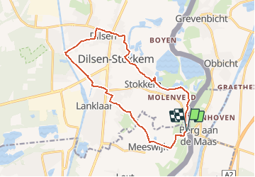
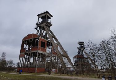
Trail Walking of 14.2 km to be discovered at Flanders, Limburg, Maasmechelen. This trail is proposed by flip96.
Description
Derde rondwandeling Peerkepad. Tussen Berg a/d Maas en Dilsen.
14km. Ca. 75 meter stijging/afdaling.
Route is NIET gemarkeerd.
Uit het boekje Peerkepad van Henk Erinkveld.
2018 ISBN: 978-94-93048-00-3
www.peerkepad.nl voor wijzigingen in route.
Positioning
Country:
Belgium
Region :
Flanders
Department/Province :
Limburg
Municipality :
Maasmechelen
Location:
Meeswijk
Start:(Dec)
Start:(UTM)
694032 ; 5654157 (31U) N.
Comments
Trails nearby
![Trail On foot Dilsen-Stokkem - Stokkem & Oud-Dilsen Blauwe ruit - Photo](https://media.geolcdn.com/t/375/260/da26fab3-9e40-4ac6-a054-30a79ea1636f.jpeg&format=jpg&maxdim=2)
![On foot On foot](https://static1.geolcdn.com/sitytour/trail-icons/100.png)
Stokkem & Oud-Dilsen Blauwe ruit
On foot
Easy
Dilsen-Stokkem,
Flanders,
Limburg,
Belgium
![](/images/other/stat-length.png)
4.7 km | 5 km-effort
1h 8min
![](https://static1.geolcdn.com/siteimages/upload/files/16400158638029165_repeat_loop_refresh_sync_direction_icon.png)
Yes
![Trail On foot Maasmechelen - Leut & Meeswijk Oranje bol - Photo](https://media.geolcdn.com/t/375/260/7b6d2e92-3c0b-4eee-8e68-d0c378b09212.jpeg&format=jpg&maxdim=2)
![On foot On foot](https://static1.geolcdn.com/sitytour/trail-icons/100.png)
Leut & Meeswijk Oranje bol
On foot
Easy
Maasmechelen,
Flanders,
Limburg,
Belgium
![](/images/other/stat-length.png)
10.3 km | 11.2 km-effort
2h 33min
![](https://static1.geolcdn.com/siteimages/upload/files/16400158638029165_repeat_loop_refresh_sync_direction_icon.png)
Yes
![Trail On foot Maasmechelen - Leut & Meeswijk Rode driehoek - Photo](https://media.geolcdn.com/t/375/260/7b6d2e92-3c0b-4eee-8e68-d0c378b09212.jpeg&format=jpg&maxdim=2)
![On foot On foot](https://static1.geolcdn.com/sitytour/trail-icons/100.png)
Leut & Meeswijk Rode driehoek
On foot
Easy
Maasmechelen,
Flanders,
Limburg,
Belgium
![](/images/other/stat-length.png)
14 km | 15 km-effort
3h 24min
![](https://static1.geolcdn.com/siteimages/upload/files/16400158638029165_repeat_loop_refresh_sync_direction_icon.png)
Yes
![Trail On foot Maasmechelen - Leut & Meeswijk Gele zeshoek - Photo](https://media.geolcdn.com/t/375/260/3a349166-7856-4cc9-a007-a2d01b733e80.jpeg&format=jpg&maxdim=2)
![On foot On foot](https://static1.geolcdn.com/sitytour/trail-icons/100.png)
Leut & Meeswijk Gele zeshoek
On foot
Easy
Maasmechelen,
Flanders,
Limburg,
Belgium
![](/images/other/stat-length.png)
7 km | 7.4 km-effort
1h 40min
![](https://static1.geolcdn.com/siteimages/upload/files/16400158638029165_repeat_loop_refresh_sync_direction_icon.png)
Yes
![Trail On foot Maasmechelen - Leut & Meeswijk Groene rechthoek - Photo](https://media.geolcdn.com/t/375/260/7b6d2e92-3c0b-4eee-8e68-d0c378b09212.jpeg&format=jpg&maxdim=2)
![On foot On foot](https://static1.geolcdn.com/sitytour/trail-icons/100.png)
Leut & Meeswijk Groene rechthoek
On foot
Easy
Maasmechelen,
Flanders,
Limburg,
Belgium
![](/images/other/stat-length.png)
3.5 km | 3.9 km-effort
53min
![](https://static1.geolcdn.com/siteimages/upload/files/16400158638029165_repeat_loop_refresh_sync_direction_icon.png)
Yes
![Trail On foot Maasmechelen - Leut & Meeswijk Blauwe ruit - Photo](https://media.geolcdn.com/t/375/260/7b6d2e92-3c0b-4eee-8e68-d0c378b09212.jpeg&format=jpg&maxdim=2)
![On foot On foot](https://static1.geolcdn.com/sitytour/trail-icons/100.png)
Leut & Meeswijk Blauwe ruit
On foot
Easy
Maasmechelen,
Flanders,
Limburg,
Belgium
![](/images/other/stat-length.png)
5 km | 5.6 km-effort
1h 15min
![](https://static1.geolcdn.com/siteimages/upload/files/16400158638029165_repeat_loop_refresh_sync_direction_icon.png)
Yes
![Trail On foot Dilsen-Stokkem - Stokkem & Oud-Dilsen Oranje bol - Photo](https://media.geolcdn.com/t/375/260/a792e625-34fe-45f0-9032-50fd0ca567ca.jpeg&format=jpg&maxdim=2)
![On foot On foot](https://static1.geolcdn.com/sitytour/trail-icons/100.png)
Stokkem & Oud-Dilsen Oranje bol
On foot
Easy
Dilsen-Stokkem,
Flanders,
Limburg,
Belgium
![](/images/other/stat-length.png)
5.4 km | 5.9 km-effort
1h 20min
![](https://static1.geolcdn.com/siteimages/upload/files/16400158638029165_repeat_loop_refresh_sync_direction_icon.png)
Yes
![Trail On foot Dilsen-Stokkem - Stokkem & Oud-Dilsen Rode driehoek - Photo](https://media.geolcdn.com/t/375/260/a792e625-34fe-45f0-9032-50fd0ca567ca.jpeg&format=jpg&maxdim=2)
![On foot On foot](https://static1.geolcdn.com/sitytour/trail-icons/100.png)
Stokkem & Oud-Dilsen Rode driehoek
On foot
Easy
Dilsen-Stokkem,
Flanders,
Limburg,
Belgium
![](/images/other/stat-length.png)
9.5 km | 10.3 km-effort
2h 21min
![](https://static1.geolcdn.com/siteimages/upload/files/16400158638029165_repeat_loop_refresh_sync_direction_icon.png)
No
![Trail Walking Maasmechelen - Maasmechelen - Site minier Connecterra - Photo](https://media.geolcdn.com/t/375/260/97d3443c-d7ce-48e6-9670-334e3f33d6e8.jpg&format=jpg&maxdim=2)
![Walking Walking](https://static1.geolcdn.com/sitytour/trail-icons/101.png)
Maasmechelen - Site minier Connecterra
Walking
Easy
(1)
Maasmechelen,
Flanders,
Limburg,
Belgium
![](/images/other/stat-length.png)
17.2 km | 21 km-effort
3h 52min
![](https://static1.geolcdn.com/siteimages/upload/files/16400158638029165_repeat_loop_refresh_sync_direction_icon.png)
Yes