![](/images/other/stat-length.png)
![Trail Snowshoes Belvédère - Cime de La Valette de Prals - Photo](https://media.geolcdn.com/t/1900/400/ext.pjpeg?maxdim=2&url=https%3A%2F%2Fstatic1.geolcdn.com%2Fsiteimages%2Fupload%2Ffiles%2F1524743153raquette.jpg)
Cime de La Valette de Prals
bozo1970
User
![Length](/images/other/stat-length.png)
Length
11.4 km
![Max alt](https://static1.geolcdn.com/siteimages/upload/files/1508320355ic_sort_altitude_max_24dp.png)
Max alt
2489 m
![Uphill gradient](https://static1.geolcdn.com/siteimages/upload/files/1508320355ic_sort_den_pos_24dp.png)
Uphill gradient
957 m
![Km-Effort](/images/other/stat-length.png)
Km-Effort
24 km
![Min alt](https://static1.geolcdn.com/siteimages/upload/files/1508320355ic_sort_altitude_min_24dp.png)
Min alt
1615 m
![Downhill gradient](https://static1.geolcdn.com/siteimages/upload/files/1508320355ic_sort_den_neg_24dp.png)
Downhill gradient
958 m
![Boucle](https://static1.geolcdn.com/siteimages/upload/files/16400158638029165_repeat_loop_refresh_sync_direction_icon.png)
Boucle
Yes
Creation date :
2020-01-01 08:29:52.0
Updated on :
2020-01-01 17:03:56.404
![Snowshoes](https://static1.geolcdn.com/sitytour/trail-icons/504.png)
5h16
Difficulty : Very difficult
![Scan this QR Code to open this trail in the SityTrail application](https://capi.geolives.com/qq0zvz2zws4bq2lad0pu/sitytour/trails/2294771/qr.png?size=200)
FREE GPS app for hiking
About
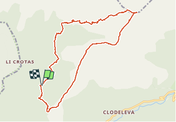
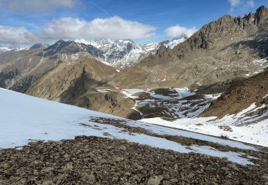
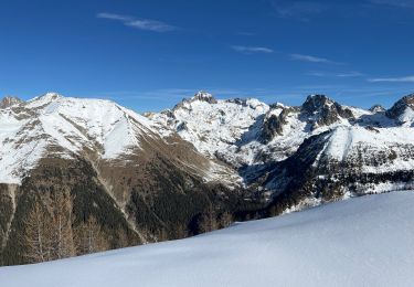
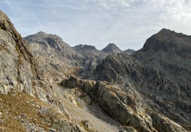
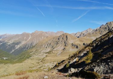
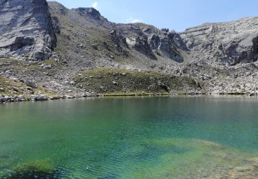
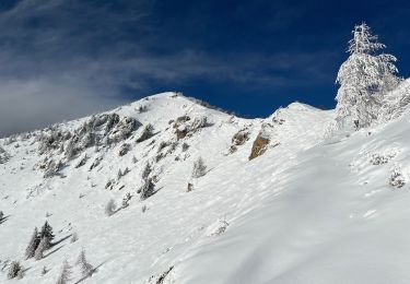
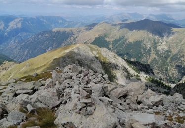
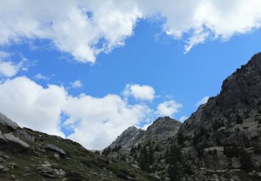
Trail Snowshoes of 11.4 km to be discovered at Provence-Alpes-Côte d'Azur, Maritime Alps, Belvédère. This trail is proposed by bozo1970.
Description
Montée de Belvédère par les vacheries de Ferisson, jusqu’au sommet et retour par les crêtes, la cime de Monjoia et la crête de Bermonnet.
5h16’ et 11,4 km
D 954m
Positioning
Country:
France
Region :
Provence-Alpes-Côte d'Azur
Department/Province :
Maritime Alps
Municipality :
Belvédère
Location:
Unknown
Start:(Dec)
Start:(UTM)
366222 ; 4878308 (32T) N.
Comments
Trails nearby
![Trail Walking Belvédère - Via Alpina - D60: Belvédère > Col de Turini - Photo](https://media.geolcdn.com/t/375/260/ext.jpg?maxdim=2&url=https%3A%2F%2Fservices.sitytrail.com%2FGeolivesWS%2FDownloadMedia.ashx%3FTrailID%3D109715%26Media%3D4424_1.jpg)
![Walking Walking](https://static1.geolcdn.com/sitytour/trail-icons/101.png)
Via Alpina - D60: Belvédère > Col de Turini
Walking
Very difficult
(1)
Belvédère,
Provence-Alpes-Côte d'Azur,
Maritime Alps,
France
![](/images/other/stat-length.png)
16.6 km | 33 km-effort
5h 30min
![](https://static1.geolcdn.com/siteimages/upload/files/16400158638029165_repeat_loop_refresh_sync_direction_icon.png)
No
![Trail Walking Belvédère - Cime de Paranova - Photo](https://media.geolcdn.com/t/375/260/cc4e7066-5464-4b8a-b1d4-23e04de7987f.jpg&format=jpg&maxdim=2)
![Walking Walking](https://static1.geolcdn.com/sitytour/trail-icons/101.png)
Cime de Paranova
Walking
Medium
Belvédère,
Provence-Alpes-Côte d'Azur,
Maritime Alps,
France
![](/images/other/stat-length.png)
9.6 km | 23 km-effort
4h 4min
![](https://static1.geolcdn.com/siteimages/upload/files/16400158638029165_repeat_loop_refresh_sync_direction_icon.png)
Yes
![Trail Snowshoes Belvédère - Mont Lapassé - Photo](https://media.geolcdn.com/t/375/260/c2e3a941-8e45-49f3-8436-b2bb41d1677c.jpg&format=jpg&maxdim=2)
![Snowshoes Snowshoes](https://static1.geolcdn.com/sitytour/trail-icons/504.png)
Mont Lapassé
Snowshoes
Medium
Belvédère,
Provence-Alpes-Côte d'Azur,
Maritime Alps,
France
![](/images/other/stat-length.png)
8.8 km | 16.8 km-effort
2h 53min
![](https://static1.geolcdn.com/siteimages/upload/files/16400158638029165_repeat_loop_refresh_sync_direction_icon.png)
Yes
![Trail Walking Belvédère - Mont Colomb - Photo](https://media.geolcdn.com/t/375/260/221e8a9d-00f9-4399-81ae-78f4e77f3f4a.jpg&format=jpg&maxdim=2)
![Walking Walking](https://static1.geolcdn.com/sitytour/trail-icons/101.png)
Mont Colomb
Walking
Very difficult
Belvédère,
Provence-Alpes-Côte d'Azur,
Maritime Alps,
France
![](/images/other/stat-length.png)
13 km | 29 km-effort
6h 10min
![](https://static1.geolcdn.com/siteimages/upload/files/16400158638029165_repeat_loop_refresh_sync_direction_icon.png)
No
![Trail Walking Belvédère - Cime de Paranova de St Grat - Photo](https://media.geolcdn.com/t/375/260/d2c334d2-54c4-421b-bf34-5ed35c389b02.jpg&format=jpg&maxdim=2)
![Walking Walking](https://static1.geolcdn.com/sitytour/trail-icons/101.png)
Cime de Paranova de St Grat
Walking
Medium
Belvédère,
Provence-Alpes-Côte d'Azur,
Maritime Alps,
France
![](/images/other/stat-length.png)
8.4 km | 21 km-effort
6h 17min
![](https://static1.geolcdn.com/siteimages/upload/files/16400158638029165_repeat_loop_refresh_sync_direction_icon.png)
Yes
![Trail Walking Belvédère - Boucle vallon verrairiers, pas de l'Arpette en boucle - Photo](https://media.geolcdn.com/t/375/260/333c0941-9cc1-4129-a0fb-f84c29a9e4a5.jpg&format=jpg&maxdim=2)
![Walking Walking](https://static1.geolcdn.com/sitytour/trail-icons/101.png)
Boucle vallon verrairiers, pas de l'Arpette en boucle
Walking
Medium
Belvédère,
Provence-Alpes-Côte d'Azur,
Maritime Alps,
France
![](/images/other/stat-length.png)
12.2 km | 28 km-effort
7h 30min
![](https://static1.geolcdn.com/siteimages/upload/files/16400158638029165_repeat_loop_refresh_sync_direction_icon.png)
Yes
![Trail Snowshoes Belvédère - Baisse de Ferisson 2 - Photo](https://media.geolcdn.com/t/375/260/be86d0cb-bdb5-418c-ad40-09477258cd07.jpg&format=jpg&maxdim=2)
![Snowshoes Snowshoes](https://static1.geolcdn.com/sitytour/trail-icons/504.png)
Baisse de Ferisson 2
Snowshoes
Difficult
Belvédère,
Provence-Alpes-Côte d'Azur,
Maritime Alps,
France
![](/images/other/stat-length.png)
10.5 km | 19 km-effort
4h 34min
![](https://static1.geolcdn.com/siteimages/upload/files/16400158638029165_repeat_loop_refresh_sync_direction_icon.png)
Yes
![Trail Walking Belvédère - Capelet inférieur et supérieur en boucle - Photo](https://media.geolcdn.com/t/375/260/3dad6987-f66b-43ef-a1a5-a74472c615b8.jpg&format=jpg&maxdim=2)
![Walking Walking](https://static1.geolcdn.com/sitytour/trail-icons/101.png)
Capelet inférieur et supérieur en boucle
Walking
Difficult
Belvédère,
Provence-Alpes-Côte d'Azur,
Maritime Alps,
France
![](/images/other/stat-length.png)
21 km | 39 km-effort
6h 0min
![](https://static1.geolcdn.com/siteimages/upload/files/16400158638029165_repeat_loop_refresh_sync_direction_icon.png)
Yes
![Trail Walking Belvédère - Cime du Diable - Photo](https://media.geolcdn.com/t/375/260/fd794d92-e352-42e3-b662-e9869abc2418.jpg&format=jpg&maxdim=2)
![Walking Walking](https://static1.geolcdn.com/sitytour/trail-icons/101.png)
Cime du Diable
Walking
Difficult
Belvédère,
Provence-Alpes-Côte d'Azur,
Maritime Alps,
France
![](/images/other/stat-length.png)
10.3 km | 25 km-effort
7h 24min
![](https://static1.geolcdn.com/siteimages/upload/files/16400158638029165_repeat_loop_refresh_sync_direction_icon.png)
Yes