![](/images/other/stat-length.png)
![Trail Walking Turenne - Bois de Turenne - Photo](https://media.geolcdn.com/t/1900/400/ext.pjpeg?maxdim=2&url=https%3A%2F%2Fservices.sitytrail.com%2FGeolivesWS%2FDownloadMedia.ashx%3FTrailID%3D229425%26Media%3Dfix__20131027161423.jpg)
Bois de Turenne
sdroneau
User
![Length](/images/other/stat-length.png)
Length
17.7 km
![Max alt](https://static1.geolcdn.com/siteimages/upload/files/1508320355ic_sort_altitude_max_24dp.png)
Max alt
359 m
![Uphill gradient](https://static1.geolcdn.com/siteimages/upload/files/1508320355ic_sort_den_pos_24dp.png)
Uphill gradient
408 m
![Km-Effort](/images/other/stat-length.png)
Km-Effort
23 km
![Min alt](https://static1.geolcdn.com/siteimages/upload/files/1508320355ic_sort_altitude_min_24dp.png)
Min alt
268 m
![Downhill gradient](https://static1.geolcdn.com/siteimages/upload/files/1508320355ic_sort_den_neg_24dp.png)
Downhill gradient
408 m
![Boucle](https://static1.geolcdn.com/siteimages/upload/files/16400158638029165_repeat_loop_refresh_sync_direction_icon.png)
Boucle
Yes
Creation date :
2014-12-10 00:00:00.0
Updated on :
2014-12-10 00:00:00.0
![Walking](https://static1.geolcdn.com/sitytour/trail-icons/101.png)
4h00
Difficulty : Medium
![Scan this QR Code to open this trail in the SityTrail application](https://capi.geolives.com/qq0zvz2zws4bq2lad0pu/sitytour/trails/229425/qr.png?size=200)
FREE GPS app for hiking
About
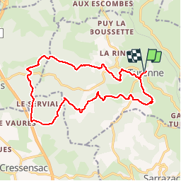
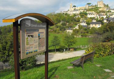
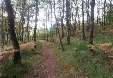
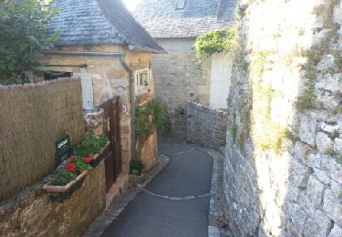
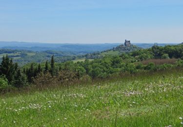
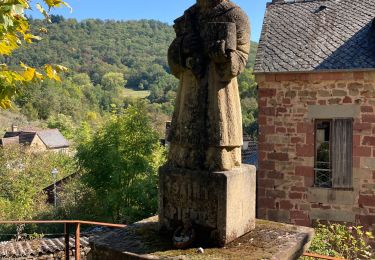
Trail Walking of 17.7 km to be discovered at New Aquitaine, Corrèze, Turenne. This trail is proposed by sdroneau.
Description
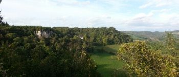
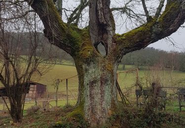
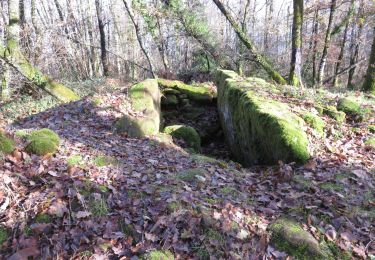
Partez à la découverte de la forêt de Turenne. Au départ du bourg de Turenne, cette balade vous fera découvrir un joli patrimoine bâti, de beaux points de vue et les charmes du causse corrézien!
Positioning
Country:
France
Region :
New Aquitaine
Department/Province :
Corrèze
Municipality :
Turenne
Location:
Unknown
Start:(Dec)
Start:(UTM)
388228 ; 4989890 (31T) N.
Comments
Trails nearby
![Trail Mountain bike Ligneyrac - Circuit de la Vicomté de Turenne - Photo](https://media.geolcdn.com/t/375/260/ext.jpg?maxdim=2&url=https%3A%2F%2Fservices.sitytrail.com%2FGeolivesWS%2FDownloadMedia.ashx%3FTrailID%3D398734%26Media%3D412020af-6043-4db5-83f9-0dd0c4c92cfd.JPG)
![Mountain bike Mountain bike](https://static1.geolcdn.com/sitytour/trail-icons/202.png)
Circuit de la Vicomté de Turenne
Mountain bike
Difficult
(2)
Ligneyrac,
New Aquitaine,
Corrèze,
France
![](/images/other/stat-length.png)
30 km | 43 km-effort
3h 30min
![](https://static1.geolcdn.com/siteimages/upload/files/16400158638029165_repeat_loop_refresh_sync_direction_icon.png)
Yes
![Trail Walking Noailhac - Balade autour de Noailhac - Photo](https://media.geolcdn.com/t/375/260/ext.jpg?maxdim=2&url=https%3A%2F%2Fservices.sitytrail.com%2FGeolivesWS%2FDownloadMedia.ashx%3FTrailID%3D149594%26Media%3De96d2a20-66fb-4d49-9d63-44dfab7eae06.jpg)
![Walking Walking](https://static1.geolcdn.com/sitytour/trail-icons/101.png)
Balade autour de Noailhac
Walking
Difficult
(2)
Noailhac,
New Aquitaine,
Corrèze,
France
![](/images/other/stat-length.png)
14.7 km | 21 km-effort
4h 0min
![](https://static1.geolcdn.com/siteimages/upload/files/16400158638029165_repeat_loop_refresh_sync_direction_icon.png)
Yes
![Trail Walking Turenne - le tour de la Vicomté - Photo](https://media.geolcdn.com/t/375/260/ext.jpg?maxdim=2&url=https%3A%2F%2Fservices.sitytrail.com%2FGeolivesWS%2FDownloadMedia.ashx%3FTrailID%3D152771%26Media%3D20120909180748.jpeg)
![Walking Walking](https://static1.geolcdn.com/sitytour/trail-icons/101.png)
le tour de la Vicomté
Walking
Medium
(2)
Turenne,
New Aquitaine,
Corrèze,
France
![](/images/other/stat-length.png)
14.1 km | 18.8 km-effort
3h 30min
![](https://static1.geolcdn.com/siteimages/upload/files/16400158638029165_repeat_loop_refresh_sync_direction_icon.png)
Yes
![Trail Walking Jugeals-Nazareth - Jugeals-Nazareth ( 8 de la Couze à la Tourmente) - Photo](https://media.geolcdn.com/t/375/260/ext.jpg?maxdim=2&url=https%3A%2F%2Fservices.sitytrail.com%2FGeolivesWS%2FDownloadMedia.ashx%3FTrailID%3D743444%26Media%3D23102de0-5f75-40b9-8fc6-6fa182d7098c.JPG)
![Walking Walking](https://static1.geolcdn.com/sitytour/trail-icons/101.png)
Jugeals-Nazareth ( 8 de la Couze à la Tourmente)
Walking
Medium
Jugeals-Nazareth,
New Aquitaine,
Corrèze,
France
![](/images/other/stat-length.png)
8.2 km | 11.3 km-effort
2h 29min
![](https://static1.geolcdn.com/siteimages/upload/files/16400158638029165_repeat_loop_refresh_sync_direction_icon.png)
Yes
![Trail Walking Noailhac - noailhac - Photo](https://media.geolcdn.com/t/375/260/ext.jpg?maxdim=2&url=https%3A%2F%2Fstatic1.geolcdn.com%2Fsiteimages%2Fupload%2Ffiles%2F1553511878bg_sport_marche.png)
![Walking Walking](https://static1.geolcdn.com/sitytour/trail-icons/101.png)
noailhac
Walking
Medium
(1)
Noailhac,
New Aquitaine,
Corrèze,
France
![](/images/other/stat-length.png)
13.8 km | 19.6 km-effort
4h 9min
![](https://static1.geolcdn.com/siteimages/upload/files/16400158638029165_repeat_loop_refresh_sync_direction_icon.png)
Yes
![Trail Walking Noailhac - Noailhac - Photo](https://media.geolcdn.com/t/375/260/b0b8d16f-875a-4884-8e5c-a708c4a97ecd.jpg&format=jpg&maxdim=2)
![Walking Walking](https://static1.geolcdn.com/sitytour/trail-icons/101.png)
Noailhac
Walking
Medium
Noailhac,
New Aquitaine,
Corrèze,
France
![](/images/other/stat-length.png)
13.8 km | 19.6 km-effort
4h 38min
![](https://static1.geolcdn.com/siteimages/upload/files/16400158638029165_repeat_loop_refresh_sync_direction_icon.png)
Yes
![Trail Walking Cressensac-Sarrazac - Sarrazac - Photo](https://media.geolcdn.com/t/375/260/20ea6751-876f-4fc5-becb-f8d816d523f6.jpg&format=jpg&maxdim=2)
![Walking Walking](https://static1.geolcdn.com/sitytour/trail-icons/101.png)
Sarrazac
Walking
Medium
Cressensac-Sarrazac,
Occitania,
Lot,
France
![](/images/other/stat-length.png)
6.3 km | 9 km-effort
1h 46min
![](https://static1.geolcdn.com/siteimages/upload/files/16400158638029165_repeat_loop_refresh_sync_direction_icon.png)
Yes
![Walking Walking](https://static1.geolcdn.com/sitytour/trail-icons/101.png)
Noailhac- Dolmen et pierre gravée (départ de Noailhac)
Walking
Medium
Noailhac,
New Aquitaine,
Corrèze,
France
![](/images/other/stat-length.png)
6.6 km | 10.4 km-effort
2h 2min
![](https://static1.geolcdn.com/siteimages/upload/files/16400158638029165_repeat_loop_refresh_sync_direction_icon.png)
Yes
![Motorbike Motorbike](https://static1.geolcdn.com/sitytour/trail-icons/402.png)
Turenne-Martel-Lacave-Rocamadour-Souillac
Motorbike
Easy
Turenne,
New Aquitaine,
Corrèze,
France
![](/images/other/stat-length.png)
87 km | 107 km-effort
3h 0min
![](https://static1.geolcdn.com/siteimages/upload/files/16400158638029165_repeat_loop_refresh_sync_direction_icon.png)
No