![](/images/other/stat-length.png)
![Trail On foot Nohèdes - Nohèdes- Gorg Estelat - Photo](https://media.geolcdn.com/t/1900/400/ea7cf2f7-d0d3-4d5f-8343-d34aeb9630c3.jpg&format=pjpeg&maxdim=2)
Nohèdes- Gorg Estelat
llech
User
![Length](/images/other/stat-length.png)
Length
22 km
![Max alt](https://static1.geolcdn.com/siteimages/upload/files/1508320355ic_sort_altitude_max_24dp.png)
Max alt
2039 m
![Uphill gradient](https://static1.geolcdn.com/siteimages/upload/files/1508320355ic_sort_den_pos_24dp.png)
Uphill gradient
1296 m
![Km-Effort](/images/other/stat-length.png)
Km-Effort
39 km
![Min alt](https://static1.geolcdn.com/siteimages/upload/files/1508320355ic_sort_altitude_min_24dp.png)
Min alt
932 m
![Downhill gradient](https://static1.geolcdn.com/siteimages/upload/files/1508320355ic_sort_den_neg_24dp.png)
Downhill gradient
1294 m
![Boucle](https://static1.geolcdn.com/siteimages/upload/files/16400158638029165_repeat_loop_refresh_sync_direction_icon.png)
Boucle
Yes
Creation date :
2019-12-31 11:09:31.69
Updated on :
2019-12-31 11:27:22.926
![On foot](https://static1.geolcdn.com/sitytour/trail-icons/100.png)
--
Difficulty : Medium
![Scan this QR Code to open this trail in the SityTrail application](https://capi.geolives.com/qq0zvz2zws4bq2lad0pu/sitytour/trails/2293858/qr.png?size=200)
FREE GPS app for hiking
About
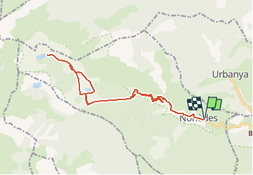
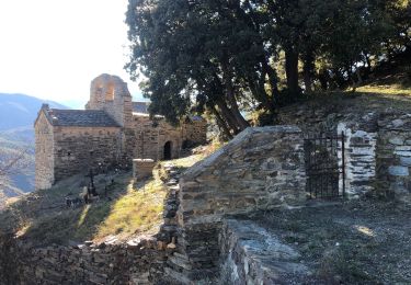
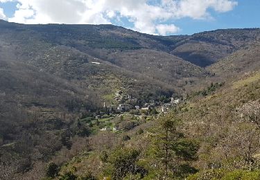
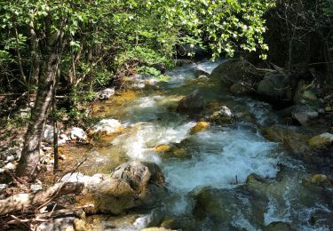
Trail On foot of 22 km to be discovered at Occitania, Pyrénées-Orientales, Nohèdes. This trail is proposed by llech.
Description
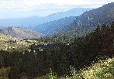
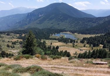
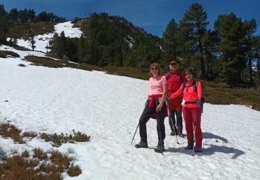
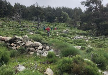
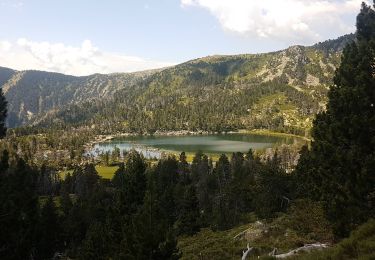
26 Décembre 2019, doux pour la saison malgré un vent du nord . Ambiance "hivernale", bois de chauffe, lacs partiellement gelés, congères de neige. Traversée de forêt avec chevreuils surpris par ma présence !
Positioning
Country:
France
Region :
Occitania
Department/Province :
Pyrénées-Orientales
Municipality :
Nohèdes
Location:
Unknown
Start:(Dec)
Start:(UTM)
441964 ; 4719127 (31T) N.
Comments
Trails nearby
![Trail Walking Olette - Lacs de Nohèdes - Photo](https://media.geolcdn.com/t/375/260/ext.jpg?maxdim=2&url=https%3A%2F%2Fservices.sitytrail.com%2FGeolivesWS%2FDownloadMedia.ashx%3FTrailID%3D347125%26Media%3Dfix__20140921151915.jpg)
![Walking Walking](https://static1.geolcdn.com/sitytour/trail-icons/101.png)
Lacs de Nohèdes
Walking
Easy
(3)
Olette,
Occitania,
Pyrénées-Orientales,
France
![](/images/other/stat-length.png)
10.5 km | 18.1 km-effort
3h 45min
![](https://static1.geolcdn.com/siteimages/upload/files/16400158638029165_repeat_loop_refresh_sync_direction_icon.png)
Yes
![Trail Walking Nohèdes - Nohedes les 3 lacs - Photo](https://media.geolcdn.com/t/375/260/8c4ec61b-d7e6-43b0-9279-06f9010a6d79.jpg&format=jpg&maxdim=2)
![Walking Walking](https://static1.geolcdn.com/sitytour/trail-icons/101.png)
Nohedes les 3 lacs
Walking
Difficult
Nohèdes,
Occitania,
Pyrénées-Orientales,
France
![](/images/other/stat-length.png)
15.7 km | 28 km-effort
6h 25min
![](https://static1.geolcdn.com/siteimages/upload/files/16400158638029165_repeat_loop_refresh_sync_direction_icon.png)
Yes
![Trail Walking Nohèdes - NOHEDE - Photo](https://media.geolcdn.com/t/375/260/feac8d4f-5aa5-4632-b31a-c79ececc04d0.jpg&format=jpg&maxdim=2)
![Walking Walking](https://static1.geolcdn.com/sitytour/trail-icons/101.png)
NOHEDE
Walking
Very difficult
Nohèdes,
Occitania,
Pyrénées-Orientales,
France
![](/images/other/stat-length.png)
16.8 km | 30 km-effort
5h 14min
![](https://static1.geolcdn.com/siteimages/upload/files/16400158638029165_repeat_loop_refresh_sync_direction_icon.png)
Yes
![Trail Walking Fuilla - 20220112 horts - Photo](https://media.geolcdn.com/t/375/260/97175881-f42b-4d5d-9b5c-7d44b50ff8a5.jpg&format=jpg&maxdim=2)
![Walking Walking](https://static1.geolcdn.com/sitytour/trail-icons/101.png)
20220112 horts
Walking
Difficult
Fuilla,
Occitania,
Pyrénées-Orientales,
France
![](/images/other/stat-length.png)
14.6 km | 27 km-effort
4h 31min
![](https://static1.geolcdn.com/siteimages/upload/files/16400158638029165_repeat_loop_refresh_sync_direction_icon.png)
Yes
![Trail Walking Nohèdes - 20200618 au départ de Nohèdes - Photo](https://media.geolcdn.com/t/375/260/beb0a5c6-cfad-41d7-a2fa-ef49cc1a58b7.jpg&format=jpg&maxdim=2)
![Walking Walking](https://static1.geolcdn.com/sitytour/trail-icons/101.png)
20200618 au départ de Nohèdes
Walking
Medium
Nohèdes,
Occitania,
Pyrénées-Orientales,
France
![](/images/other/stat-length.png)
13.7 km | 24 km-effort
5h 22min
![](https://static1.geolcdn.com/siteimages/upload/files/16400158638029165_repeat_loop_refresh_sync_direction_icon.png)
Yes
![Trail Walking Urbanya - urbanya 2 - Photo](https://media.geolcdn.com/t/375/260/ext.jpg?maxdim=2&url=https%3A%2F%2Fservices.sitytrail.com%2FGeolivesWS%2FDownloadMedia.ashx%3FTrailID%3D745867%26Media%3Dfix__20170320150411.jpg)
![Walking Walking](https://static1.geolcdn.com/sitytour/trail-icons/101.png)
urbanya 2
Walking
Very easy
Urbanya,
Occitania,
Pyrénées-Orientales,
France
![](/images/other/stat-length.png)
16.6 km | 26 km-effort
5h 25min
![](https://static1.geolcdn.com/siteimages/upload/files/16400158638029165_repeat_loop_refresh_sync_direction_icon.png)
Yes
![Trail Walking Nohèdes - les lacs de Nohede - Photo](https://media.geolcdn.com/t/375/260/ext.jpg?maxdim=2&url=https%3A%2F%2Fservices.sitytrail.com%2FGeolivesWS%2FDownloadMedia.ashx%3FTrailID%3D600194%26Media%3D20160718121704.jpg)
![Walking Walking](https://static1.geolcdn.com/sitytour/trail-icons/101.png)
les lacs de Nohede
Walking
Medium
Nohèdes,
Occitania,
Pyrénées-Orientales,
France
![](/images/other/stat-length.png)
29 km | 55 km-effort
6h 44min
![](https://static1.geolcdn.com/siteimages/upload/files/16400158638029165_repeat_loop_refresh_sync_direction_icon.png)
No
![Trail Walking Nohèdes - lacs negre estellat et clot nohèdes - Photo](https://media.geolcdn.com/t/375/260/1b49b954-3372-4168-a6d8-c8c83b1eee5c.jpg&format=jpg&maxdim=2)
![Walking Walking](https://static1.geolcdn.com/sitytour/trail-icons/101.png)
lacs negre estellat et clot nohèdes
Walking
Medium
Nohèdes,
Occitania,
Pyrénées-Orientales,
France
![](/images/other/stat-length.png)
58 km | 102 km-effort
3h 30min
![](https://static1.geolcdn.com/siteimages/upload/files/16400158638029165_repeat_loop_refresh_sync_direction_icon.png)
No
![Trail Walking Conat - CONAT Betllans Nohedes - Photo](https://media.geolcdn.com/t/375/260/0aaa7f8a-117e-4cab-8623-36a4e7c365d3.jpg&format=jpg&maxdim=2)
![Walking Walking](https://static1.geolcdn.com/sitytour/trail-icons/101.png)
CONAT Betllans Nohedes
Walking
Medium
Conat,
Occitania,
Pyrénées-Orientales,
France
![](/images/other/stat-length.png)
10.6 km | 15.1 km-effort
3h 4min
![](https://static1.geolcdn.com/siteimages/upload/files/16400158638029165_repeat_loop_refresh_sync_direction_icon.png)
Yes