Trail Walking Saint-Cézaire-sur-Siagne - Gué de la Pare - Pont de Siagne  - Photo
 fresteu
fresteu

User

© OpenStreetMap contributors
Length
Length
6.5 km
Max alt
Max alt
662 m
Uphill gradient
Uphill gradient
380 m
Km-Effort
Km-Effort  
12 km
Min alt
Min alt
243 m
Downhill gradient
Downhill gradient
530 m
Boucle
Boucle
No
Creation date :
2019-12-22 13:06:20.964
Updated on :
2019-12-23 14:56:15.497

(0 Reviews)

Walking
Walking
2h38
Difficulty : Difficult

Scan this QR Code to open this trail in the SityTrail application

FREE GPS app for hiking

Logo SityTrail SityTrail

IGN / Geographical institutes

Download SityTrail from the App Store Download SityTrail from Google Play

Logo SityTrail SityTrail World

The world is yours!

Download SityTrail from the App Store Download SityTrail from Google Play Download SityTrail on Huawei AppGallery

About

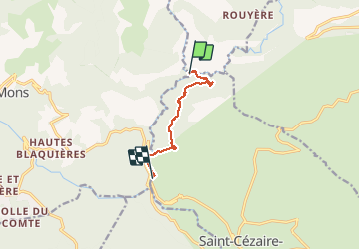
Trail Walking of 6.5 km to be discovered at Provence-Alpes-Côte d'Azur, Maritime Alps, Saint-Cézaire-sur-Siagne. This trail is proposed by fresteu.

Description

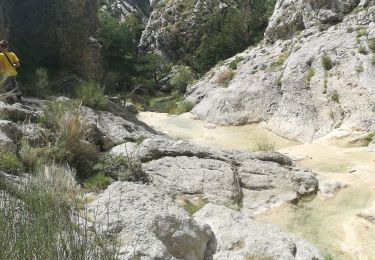
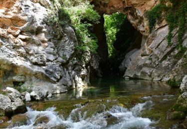
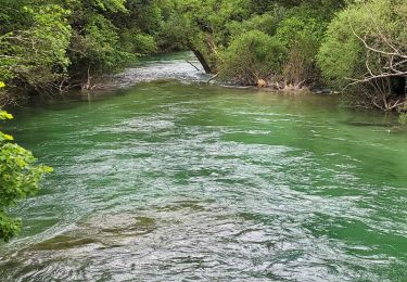
Le retour d'une rando à partir du Pont de Siagne.
La fin du parcours passe par les milliers (?) de marches qui longent les tuyaux de l'usine hydro électrique.

Elevation profile

Positioning

Country:
France
Region :
Provence-Alpes-Côte d'Azur
Department/Province :
Maritime Alps
Municipality :
Saint-Cézaire-sur-Siagne
Location:
Unknown
Start:(UTM)
320683 ; 4840293 (32T) N.

Trails nearby

Trail Walking Escragnolles - Casade du Ray (Clars) depuis les Gallants - Photo
Walking
Reich

Walking

Very easy
(1)
Escragnolles, Provence-Alpes-Côte d'Azur, Maritime Alps, France
938 m | 1.3 km-effort
20min
No
Trail Walking Saint-Vallier-de-Thiey - Arche de Ponadieu Source de la Pare Baou Mourine Vieux Pont  - Photo
Walking
GUIDE
jouans

Walking

Very difficult
Saint-Vallier-de-Thiey, Provence-Alpes-Côte d'Azur, Maritime Alps, France
19.2 km | 32 km-effort
7h 20min
Yes
Trail On foot Escragnolles - Plateau de Briasq - Photo
On foot
GUIDE+

On foot

Medium
Escragnolles, Provence-Alpes-Côte d'Azur, Maritime Alps, France
14.1 km | 22 km-effort
4h 56min
Yes
Trail Walking Saint-Cézaire-sur-Siagne - Col de Cabris - Photo
Walking
jlrayon

Walking

Easy
(1)
Saint-Cézaire-sur-Siagne, Provence-Alpes-Côte d'Azur, Maritime Alps, France
7.3 km | 9.7 km-effort
3h 0min
Yes
Trail Walking Saint-Vallier-de-Thiey - St Vallier de Thiey - Col de la Lèque - Chapelle St Jean - Arche Ponadieu - Photo
Walking
LtZIP

Walking

Medium
Saint-Vallier-de-Thiey, Provence-Alpes-Côte d'Azur, Maritime Alps, France
14.1 km | 21 km-effort
4h 44min
Yes
Trail Walking Saint-Cézaire-sur-Siagne - Le canal et la rivière de la Siagne  - Photo
Walking
Palimpseste

Walking

Medium
Saint-Cézaire-sur-Siagne, Provence-Alpes-Côte d'Azur, Maritime Alps, France
8.4 km | 13.9 km-effort
3h 8min
Yes
Trail Walking Saint-Vallier-de-Thiey - St Vallier : Pare2 - Photo
Walking
ETMU5496

Walking

Difficult
Saint-Vallier-de-Thiey, Provence-Alpes-Côte d'Azur, Maritime Alps, France
17.7 km | 29 km-effort
6h 35min
Yes
Trail Mountain bike Mons - Mons => Les moulins par Mont  - Photo
Mountain bike
ajpbm

Mountain bike

Medium
Mons, Provence-Alpes-Côte d'Azur, Var, France
15.3 km | 22 km-effort
3h 10min
No
Trail Walking Saint-Vallier-de-Thiey - 2)_Baou_Mourine_par_Arche_du__Saint-Vall - Photo
Walking
ETMU5496

Walking

Difficult
Saint-Vallier-de-Thiey, Provence-Alpes-Côte d'Azur, Maritime Alps, France
19.3 km | 33 km-effort
7h 31min
Yes


Close
My subscriptions