![](/images/other/stat-length.png)
![Trail Electric bike Maaseik - Naar Maasvallei - Photo](https://media.geolcdn.com/t/1900/400/035fa3a6-6595-49c0-a626-4efbde6ccc5c.jpg&format=pjpeg&maxdim=2)
Naar Maasvallei
bometdehamer
User
![Length](/images/other/stat-length.png)
Length
54 km
![Max alt](https://static1.geolcdn.com/siteimages/upload/files/1508320355ic_sort_altitude_max_24dp.png)
Max alt
97 m
![Uphill gradient](https://static1.geolcdn.com/siteimages/upload/files/1508320355ic_sort_den_pos_24dp.png)
Uphill gradient
372 m
![Km-Effort](/images/other/stat-length.png)
Km-Effort
59 km
![Min alt](https://static1.geolcdn.com/siteimages/upload/files/1508320355ic_sort_altitude_min_24dp.png)
Min alt
21 m
![Downhill gradient](https://static1.geolcdn.com/siteimages/upload/files/1508320355ic_sort_den_neg_24dp.png)
Downhill gradient
373 m
![Boucle](https://static1.geolcdn.com/siteimages/upload/files/16400158638029165_repeat_loop_refresh_sync_direction_icon.png)
Boucle
Yes
Creation date :
2019-12-19 08:49:04.0
Updated on :
2019-12-19 15:23:05.493
![Electric bike](https://static1.geolcdn.com/sitytour/trail-icons/205.png)
3h26
Difficulty : Easy
![Scan this QR Code to open this trail in the SityTrail application](https://capi.geolives.com/qq0zvz2zws4bq2lad0pu/sitytour/trails/2287786/qr.png?size=200)
FREE GPS app for hiking
About
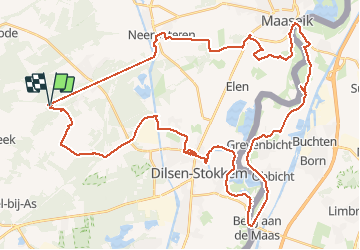
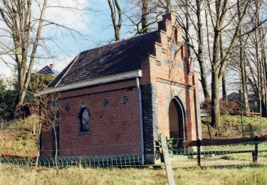
Trail Electric bike of 54 km to be discovered at Flanders, Limburg, Maaseik. This trail is proposed by bometdehamer.
Description
Van camping Zavelbos via fietsknooppunten naar de Maasvallei, met veer over de Maas in Stokkem en langs de Nederlandse Maaskant naar Maaseik. Zavelbos,38,42,44,48,49,50,27,19,13,24,26,45,47,44,42,38 en terug Zavelbos.
Positioning
Country:
Belgium
Region :
Flanders
Department/Province :
Limburg
Municipality :
Maaseik
Location:
Opoeteren
Start:(Dec)
Start:(UTM)
684224 ; 5659541 (31U) N.
Comments
Trails nearby
![Trail Walking Maaseik - 2021-11-06_16h45m30_930 - Photo](https://media.geolcdn.com/t/375/260/784b545d-0697-41ea-9878-b528d019e3de.jpg&format=jpg&maxdim=2)
![Walking Walking](https://static1.geolcdn.com/sitytour/trail-icons/101.png)
2021-11-06_16h45m30_930
Walking
Easy
(1)
Maaseik,
Flanders,
Limburg,
Belgium
![](/images/other/stat-length.png)
17.8 km | 20 km-effort
4h 38min
![](https://static1.geolcdn.com/siteimages/upload/files/16400158638029165_repeat_loop_refresh_sync_direction_icon.png)
Yes
![Trail On foot As - Heiderbos blauwe ruit - Photo](https://media.geolcdn.com/t/375/260/e65c145e-dca4-4d58-ae17-fc8ca78c84c8.jpeg&format=jpg&maxdim=2)
![On foot On foot](https://static1.geolcdn.com/sitytour/trail-icons/100.png)
Heiderbos blauwe ruit
On foot
Easy
As,
Flanders,
Limburg,
Belgium
![](/images/other/stat-length.png)
7.7 km | 8.5 km-effort
1h 56min
![](https://static1.geolcdn.com/siteimages/upload/files/16400158638029165_repeat_loop_refresh_sync_direction_icon.png)
Yes
![Trail On foot Oudsbergen - Bosbeekvallei Rode vierkant - Photo](https://media.geolcdn.com/t/375/260/05b94e83-943e-4a8a-b6a2-23050984110f.jpeg&format=jpg&maxdim=2)
![On foot On foot](https://static1.geolcdn.com/sitytour/trail-icons/100.png)
Bosbeekvallei Rode vierkant
On foot
Easy
Oudsbergen,
Flanders,
Limburg,
Belgium
![](/images/other/stat-length.png)
6.3 km | 6.8 km-effort
1h 32min
![](https://static1.geolcdn.com/siteimages/upload/files/16400158638029165_repeat_loop_refresh_sync_direction_icon.png)
Yes
![Trail On foot Maaseik - Oudsberg Blauwe ruit - Photo](https://media.geolcdn.com/t/375/260/bd436d3d-7786-4c28-877a-e4f4a8ff02e7.jpeg&format=jpg&maxdim=2)
![On foot On foot](https://static1.geolcdn.com/sitytour/trail-icons/100.png)
Oudsberg Blauwe ruit
On foot
Easy
Maaseik,
Flanders,
Limburg,
Belgium
![](/images/other/stat-length.png)
7 km | 8 km-effort
1h 48min
![](https://static1.geolcdn.com/siteimages/upload/files/16400158638029165_repeat_loop_refresh_sync_direction_icon.png)
Yes
![Trail On foot Oudsbergen - Oudsberg Blauwe ruit - Photo](https://media.geolcdn.com/t/375/260/587c0d46-8fc2-4453-a2ba-63c77f582c07.jpeg&format=jpg&maxdim=2)
![On foot On foot](https://static1.geolcdn.com/sitytour/trail-icons/100.png)
Oudsberg Blauwe ruit
On foot
Easy
Oudsbergen,
Flanders,
Limburg,
Belgium
![](/images/other/stat-length.png)
4 km | 4.5 km-effort
1h 0min
![](https://static1.geolcdn.com/siteimages/upload/files/16400158638029165_repeat_loop_refresh_sync_direction_icon.png)
Yes
![Trail On foot Maaseik - Oudsberg Groene rechthoek - Photo](https://media.geolcdn.com/t/375/260/87a0d596-d580-45a8-874d-5f76f3c7dee5.jpeg&format=jpg&maxdim=2)
![On foot On foot](https://static1.geolcdn.com/sitytour/trail-icons/100.png)
Oudsberg Groene rechthoek
On foot
Easy
Maaseik,
Flanders,
Limburg,
Belgium
![](/images/other/stat-length.png)
3.1 km | 3.4 km-effort
45min
![](https://static1.geolcdn.com/siteimages/upload/files/16400158638029165_repeat_loop_refresh_sync_direction_icon.png)
Yes
![Trail On foot Maaseik - Oudsberg Oranje bol - Photo](https://media.geolcdn.com/t/375/260/bd436d3d-7786-4c28-877a-e4f4a8ff02e7.jpeg&format=jpg&maxdim=2)
![On foot On foot](https://static1.geolcdn.com/sitytour/trail-icons/100.png)
Oudsberg Oranje bol
On foot
Easy
Maaseik,
Flanders,
Limburg,
Belgium
![](/images/other/stat-length.png)
11.7 km | 13.4 km-effort
3h 2min
![](https://static1.geolcdn.com/siteimages/upload/files/16400158638029165_repeat_loop_refresh_sync_direction_icon.png)
Yes
![Trail On foot Dilsen-Stokkem - Bergerven Gele zeshoek - Photo](https://media.geolcdn.com/t/375/260/050a923b-2af9-40e2-aacc-99779fc4e3d7.jpeg&format=jpg&maxdim=2)
![On foot On foot](https://static1.geolcdn.com/sitytour/trail-icons/100.png)
Bergerven Gele zeshoek
On foot
Easy
Dilsen-Stokkem,
Flanders,
Limburg,
Belgium
![](/images/other/stat-length.png)
15.1 km | 17.5 km-effort
3h 58min
![](https://static1.geolcdn.com/siteimages/upload/files/16400158638029165_repeat_loop_refresh_sync_direction_icon.png)
Yes
![Trail On foot Maaseik - Bergerven Blauwe ruit - Photo](https://media.geolcdn.com/t/375/260/050a923b-2af9-40e2-aacc-99779fc4e3d7.jpeg&format=jpg&maxdim=2)
![On foot On foot](https://static1.geolcdn.com/sitytour/trail-icons/100.png)
Bergerven Blauwe ruit
On foot
Easy
Maaseik,
Flanders,
Limburg,
Belgium
![](/images/other/stat-length.png)
7.4 km | 8.3 km-effort
1h 53min
![](https://static1.geolcdn.com/siteimages/upload/files/16400158638029165_repeat_loop_refresh_sync_direction_icon.png)
Yes