Trail Walking Guebwiller - 5530264-Rimbach près Guebwiller - Photo

5530264-Rimbach près Guebwiller

 E.BURCK
E.BURCK

User

© OpenStreetMap contributors
Length
Length
10.3 km
Max alt
Max alt
660 m
Uphill gradient
Uphill gradient
380 m
Km-Effort
Km-Effort  
15.4 km
Min alt
Min alt
368 m
Downhill gradient
Downhill gradient
377 m
Boucle
Boucle
Yes
Creation date :
2019-12-14 17:00:14.328
Updated on :
2019-12-18 14:11:58.381

(1 Reviews)

Walking
Walking
3h10
Difficulty : Difficult

Scan this QR Code to open this trail in the SityTrail application

FREE GPS app for hiking

Logo SityTrail SityTrail

IGN / Geographical institutes

Download SityTrail from the App Store Download SityTrail from Google Play

Logo SityTrail SityTrail World

The world is yours!

Download SityTrail from the App Store Download SityTrail from Google Play Download SityTrail on Huawei AppGallery

About

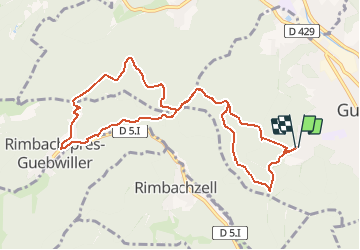
Trail Walking of 10.3 km to be discovered at Grand Est, Haut-Rhin, Guebwiller. This trail is proposed by E.BURCK.

Description

Une balade facile pour ceux qui veulent marcher avant et/ou après le repas de Noël. 330 m de dénivelé et 10 km.
ACCÈS :  
- à Guebwiller prendre la rue du Vieil Armand vers le Lycée Kastler puis la rue du Sudel vers le parcours de santé.
PARKING :
-parking du parcours de santé de Guebwiller.
       47.9049953,       7.1970504 ou  
   N 47°54'18.0", E 07°11'49.2"
RESTAURATION :      
Restaurant à l'Aigle d'Or, chez Marck à Rimbach.
Tél: 03 89 76 89 90

Elevation profile

Positioning

Country:
France
Region :
Grand Est
Department/Province :
Haut-Rhin
Municipality :
Guebwiller
Location:
Unknown
Start:(UTM)
365285 ; 5307327 (32T) N.

Comments

Please log in to post a review or rate the element


Trails nearby

Trail Mountain bike Guebwiller - P4  Circuits du Florival 2021   - Photo
Mountain bike
duchaine.nicolas

Mountain bike

Medium
(1)
Guebwiller, Grand Est, Haut-Rhin, France
40 km | 53 km-effort
4h 31min
No
Trail Walking Murbach - Rando du 01/08/2024 - Photo
Walking
boubou68

Walking

Very difficult
Murbach, Grand Est, Haut-Rhin, France
18.9 km | 30 km-effort
5h 53min
Yes
Trail Walking Soultz-Haut-Rhin - Rando Marcheurs..04/04_2025 - Photo
Walking
boubou68

Walking

Very difficult
Soultz-Haut-Rhin, Grand Est, Haut-Rhin, France
21 km | 35 km-effort
4h 42min
Yes
Trail Walking Jungholtz - Rando Retrouvailles...01/03/2024.par Jean Marc - Photo
Walking
boubou68

Walking

Very difficult
Jungholtz, Grand Est, Haut-Rhin, France
11.3 km | 19.2 km-effort
1h 35min
Yes
Trail Walking Murbach - La
Walking
boubou68

Walking

Very difficult
Murbach, Grand Est, Haut-Rhin, France
14.7 km | 28 km-effort
4h 3min
Yes
Trail Walking Murbach - Murbach - Photo
Walking
oscar1

Walking

Difficult
Murbach, Grand Est, Haut-Rhin, France
15.4 km | 25 km-effort
4h 25min
Yes
Trail Walking Soultz-Haut-Rhin - Rando avec 0mar et Mouloud..18/02/2023 - Photo
Walking
boubou68

Walking

Very difficult
Soultz-Haut-Rhin, Grand Est, Haut-Rhin, France
12 km | 20 km-effort
3h 9min
Yes
Trail Road bike Issenheim - EXT-65 Issenheim-01 - Photo
Road bike
GUIDE
Specialized77

Road bike

Easy
Issenheim, Grand Est, Haut-Rhin, France
65 km | 73 km-effort
3h 54min
Yes
Trail Walking Orschwihr - Boucle pour Soultzmatt - Photo
Walking
GuyVachet

Walking

Medium
Orschwihr, Grand Est, Haut-Rhin, France
12.4 km | 16.5 km-effort
4h 4min
Yes


Close
My subscriptions