Trail Walking Fuilla - Le pla de Horts - Photo
 Arcy
Arcy

User

© OpenStreetMap contributors
Length
Length
15.2 km
Max alt
Max alt
1446 m
Uphill gradient
Uphill gradient
1041 m
Km-Effort
Km-Effort  
29 km
Min alt
Min alt
423 m
Downhill gradient
Downhill gradient
1039 m
Boucle
Boucle
Yes
Creation date :
2019-12-11 08:00:00.0
Updated on :
2019-12-12 18:23:09.915

(0 Reviews)

Walking
Walking
6h21
Difficulty : Unknown

Scan this QR Code to open this trail in the SityTrail application

FREE GPS app for hiking

Logo SityTrail SityTrail

IGN / Geographical institutes

Download SityTrail from the App Store Download SityTrail from Google Play

Logo SityTrail SityTrail World

The world is yours!

Download SityTrail from the App Store Download SityTrail from Google Play Download SityTrail on Huawei AppGallery

About

Trail Walking of 15.2 km to be discovered at Occitania, Pyrénées-Orientales, Fuilla. This trail is proposed by Arcy.

Description

Martial - 2019 11
Randonnée qui monte régulièrement et qui n'est pas très difficile. de beaux paysages. A . ne pas faire en été avec la chaleur.
Belle forêt avec des arbres qui avaient des branches qui poussent dans tous les sens avec de la mousse. Un peu féérique

Elevation profile

Photos

Positioning

Country:
France
Region :
Occitania
Department/Province :
Pyrénées-Orientales
Municipality :
Fuilla
Location:
Unknown
Start:(UTM)
448356 ; 4715624 (31T) N.

Trails nearby

Trail Walking Ria-Sirach - Sirach-Taurinya-Saint Michel de Cuxa - Photo
Walking
ThonyM

Walking

Easy
(2)
Ria-Sirach, Occitania, Pyrénées-Orientales, France
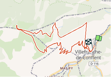
13.5 km | 17.2 km-effort
2h 31min
Yes
Trail Motor Codalet - Prades - Villefranche de Conflent - Evol  - Photo
Motor
crijack

Motor

Easy
(1)
Codalet, Occitania, Pyrénées-Orientales, France
36 km | 48 km-effort
3h 47min
No
Trail Mountain bike Ria-Sirach - cami del pi - Photo
Mountain bike
fine66

Mountain bike

Very easy
(1)
Ria-Sirach, Occitania, Pyrénées-Orientales, France
11.2 km | 18.4 km-effort
1h 52min
Yes
Trail Walking Taurinya - le Canigou depuis le col de Millères - Photo
Walking
Machaon6

Walking

Difficult
(1)
Taurinya, Occitania, Pyrénées-Orientales, France
22 km | 48 km-effort
8h 30min
Yes
Trail Walking Codalet - le tour de saint Michel de cuxià - Photo
Walking
michelle.ceres@wanadoo.fr

Walking

Medium
Codalet, Occitania, Pyrénées-Orientales, France
8.1 km | 11.1 km-effort
2h 37min
Yes
Trail Walking Codalet - Codalet /Taurinya / St Michel de cuca - Photo
Walking
robertperello

Walking

Medium
Codalet, Occitania, Pyrénées-Orientales, France
14.4 km | 21 km-effort
3h 49min
No
Trail Walking Fuilla - fuilla (66) - Photo
Walking
66Gribouille83

Walking

Difficult
Fuilla, Occitania, Pyrénées-Orientales, France
11.7 km | 17.8 km-effort
5h 57min
Yes
Trail Walking Corneilla-de-Conflent - Corneilla de Conflent - Photo
Walking
ombrabella

Walking

Easy
Corneilla-de-Conflent, Occitania, Pyrénées-Orientales, France
12.8 km | 17.7 km-effort
3h 27min
Yes
Trail Walking Prades - codalet . coll de Clara . abbaye St Michel de Cuxa . canal bohère - Photo
Walking
GUIDE
stef789

Walking

Medium
Prades, Occitania, Pyrénées-Orientales, France
9.8 km | 14.7 km-effort
4h 21min
Yes


Close
My subscriptions