


Chalet oredon - saint lary

ARVIEU
User
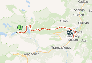

Length
22 km

Max alt
2247 m

Uphill gradient
866 m
Km-Effort
37 km

Min alt
792 m

Downhill gradient
1923 m
Boucle
No
Creation date :
2019-12-11 13:45:06.439
Updated on :
2019-12-11 13:46:10.982
8h20
Difficulty : Difficult

FREE GPS app for hiking
 SityTrail
IGN / Geographical institutes
SityTrail Plus
The world is yours!
About
Trail On foot of 22 km to be discovered at Occitania, Hautespyrenees, Aragnouet. This trail is proposed by ARVIEU.
Positioning
Country:
France
Region :
Occitania
Department/Province :
Hautespyrenees
Municipality :
Aragnouet
Location:
Unknown
Start:(Dec)
Start:(UTM)
268643 ; 4745411 (31T) N.
Comments