![](/images/other/stat-length.png)
![Trail On foot Valensole - le chêne de Maragonelle ( Valensole ) - Photo](https://media.geolcdn.com/t/1900/400/ext.pjpeg?maxdim=2&url=https%3A%2F%2Fstatic1.geolcdn.com%2Fsiteimages%2Fupload%2Ffiles%2F1545311037marcheuse_200dpi.jpg)
le chêne de Maragonelle ( Valensole )
PITOUSSAINT
User
![Length](/images/other/stat-length.png)
Length
9.7 km
![Max alt](https://static1.geolcdn.com/siteimages/upload/files/1508320355ic_sort_altitude_max_24dp.png)
Max alt
573 m
![Uphill gradient](https://static1.geolcdn.com/siteimages/upload/files/1508320355ic_sort_den_pos_24dp.png)
Uphill gradient
288 m
![Km-Effort](/images/other/stat-length.png)
Km-Effort
13.5 km
![Min alt](https://static1.geolcdn.com/siteimages/upload/files/1508320355ic_sort_altitude_min_24dp.png)
Min alt
335 m
![Downhill gradient](https://static1.geolcdn.com/siteimages/upload/files/1508320355ic_sort_den_neg_24dp.png)
Downhill gradient
287 m
![Boucle](https://static1.geolcdn.com/siteimages/upload/files/16400158638029165_repeat_loop_refresh_sync_direction_icon.png)
Boucle
Yes
Creation date :
2019-12-10 17:49:03.628
Updated on :
2019-12-10 17:55:54.247
![On foot](https://static1.geolcdn.com/sitytour/trail-icons/100.png)
3h00
Difficulty : Easy
![Scan this QR Code to open this trail in the SityTrail application](https://capi.geolives.com/qq0zvz2zws4bq2lad0pu/sitytour/trails/2282518/qr.png?size=200)
FREE GPS app for hiking
About
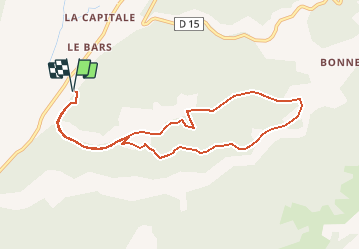
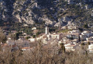
Trail On foot of 9.7 km to be discovered at Provence-Alpes-Côte d'Azur, Alpes-de-Haute-Provence, Valensole. This trail is proposed by PITOUSSAINT.
Description
Très belle rando qui va vous mener près d'un chêne multi centenaire vers du vieux village de Maragonelle aujourd'hui en ruine.
Positioning
Country:
France
Region :
Provence-Alpes-Côte d'Azur
Department/Province :
Alpes-de-Haute-Provence
Municipality :
Valensole
Location:
Unknown
Start:(Dec)
Start:(UTM)
732654 ; 4860638 (31T) N.
Comments
Trails nearby
![Trail Walking Villeneuve - VILLENEUVE La Roche amere , Chapelle notre-dame de la Roche moy n - Photo](https://media.geolcdn.com/t/375/260/78d42f2f-150b-404c-9269-37a1d30b783e.jpg&format=jpg&maxdim=2)
![Walking Walking](https://static1.geolcdn.com/sitytour/trail-icons/101.png)
VILLENEUVE La Roche amere , Chapelle notre-dame de la Roche moy n
Walking
Medium
Villeneuve,
Provence-Alpes-Côte d'Azur,
Alpes-de-Haute-Provence,
France
![](/images/other/stat-length.png)
13.1 km | 18.2 km-effort
4h 38min
![](https://static1.geolcdn.com/siteimages/upload/files/16400158638029165_repeat_loop_refresh_sync_direction_icon.png)
Yes
![Trail Mountain bike Volx - Volx/Montaigu/Bellevue/La Garde - Photo](https://media.geolcdn.com/t/375/260/ext.jpg?maxdim=2&url=https%3A%2F%2Fstatic1.geolcdn.com%2Fsiteimages%2Fupload%2Ffiles%2F1524743154velo.jpg)
![Mountain bike Mountain bike](https://static1.geolcdn.com/sitytour/trail-icons/202.png)
Volx/Montaigu/Bellevue/La Garde
Mountain bike
Medium
(1)
Volx,
Provence-Alpes-Côte d'Azur,
Alpes-de-Haute-Provence,
France
![](/images/other/stat-length.png)
16.2 km | 24 km-effort
1h 33min
![](https://static1.geolcdn.com/siteimages/upload/files/16400158638029165_repeat_loop_refresh_sync_direction_icon.png)
Yes
![Trail Walking Villeneuve - VILLENEUVE. NOTRE-DAME DE LA ROCHE O L S - Photo](https://media.geolcdn.com/t/375/260/e12c610c-f05d-407f-8a61-1557f236cc62.jpg&format=jpg&maxdim=2)
![Walking Walking](https://static1.geolcdn.com/sitytour/trail-icons/101.png)
VILLENEUVE. NOTRE-DAME DE LA ROCHE O L S
Walking
Medium
Villeneuve,
Provence-Alpes-Côte d'Azur,
Alpes-de-Haute-Provence,
France
![](/images/other/stat-length.png)
16.1 km | 23 km-effort
4h 25min
![](https://static1.geolcdn.com/siteimages/upload/files/16400158638029165_repeat_loop_refresh_sync_direction_icon.png)
Yes
![Trail Walking Oraison - oraison autour d'Aurėlie - Photo](https://media.geolcdn.com/t/375/260/ext.jpg?maxdim=2&url=https%3A%2F%2Fstatic1.geolcdn.com%2Fsiteimages%2Fupload%2Ffiles%2F1553511878bg_sport_marche.png)
![Walking Walking](https://static1.geolcdn.com/sitytour/trail-icons/101.png)
oraison autour d'Aurėlie
Walking
Medium
(1)
Oraison,
Provence-Alpes-Côte d'Azur,
Alpes-de-Haute-Provence,
France
![](/images/other/stat-length.png)
6.6 km | 7.6 km-effort
1h 43min
![](https://static1.geolcdn.com/siteimages/upload/files/16400158638029165_repeat_loop_refresh_sync_direction_icon.png)
Yes
![Trail Walking Volx - VOLX . TOUR DE LA ROCHE AMÈRE 0 L M - Photo](https://media.geolcdn.com/t/375/260/6872c8a4-7e66-489f-a2b2-1aad1480f59e.jpg&format=jpg&maxdim=2)
![Walking Walking](https://static1.geolcdn.com/sitytour/trail-icons/101.png)
VOLX . TOUR DE LA ROCHE AMÈRE 0 L M
Walking
Easy
Volx,
Provence-Alpes-Côte d'Azur,
Alpes-de-Haute-Provence,
France
![](/images/other/stat-length.png)
12.7 km | 17.3 km-effort
3h 34min
![](https://static1.geolcdn.com/siteimages/upload/files/16400158638029165_repeat_loop_refresh_sync_direction_icon.png)
Yes
![Trail Walking Volx - VOLX . CRETES DE VOLX O L M - Photo](https://media.geolcdn.com/t/375/260/33e323f9-3969-4d23-a293-27950b255122.jpg&format=jpg&maxdim=2)
![Walking Walking](https://static1.geolcdn.com/sitytour/trail-icons/101.png)
VOLX . CRETES DE VOLX O L M
Walking
Difficult
Volx,
Provence-Alpes-Côte d'Azur,
Alpes-de-Haute-Provence,
France
![](/images/other/stat-length.png)
15.2 km | 24 km-effort
5h 38min
![](https://static1.geolcdn.com/siteimages/upload/files/16400158638029165_repeat_loop_refresh_sync_direction_icon.png)
Yes
![Trail Walking Valensole - 1Chapelle Sainte Madeleine, Villedieu. - Photo](https://media.geolcdn.com/t/375/260/388f6884-2209-4f6a-acdc-4648387b9294.jpg&format=jpg&maxdim=2)
![Walking Walking](https://static1.geolcdn.com/sitytour/trail-icons/101.png)
1Chapelle Sainte Madeleine, Villedieu.
Walking
Medium
Valensole,
Provence-Alpes-Côte d'Azur,
Alpes-de-Haute-Provence,
France
![](/images/other/stat-length.png)
8 km | 10.8 km-effort
2h 28min
![](https://static1.geolcdn.com/siteimages/upload/files/16400158638029165_repeat_loop_refresh_sync_direction_icon.png)
Yes
![Trail On foot Volx - Tour de Bellevue - Photo](https://media.geolcdn.com/t/375/260/eaebe00b-e666-401d-910f-5551225110f2.jpeg&format=jpg&maxdim=2)
![On foot On foot](https://static1.geolcdn.com/sitytour/trail-icons/100.png)
Tour de Bellevue
On foot
Easy
Volx,
Provence-Alpes-Côte d'Azur,
Alpes-de-Haute-Provence,
France
![](/images/other/stat-length.png)
8.6 km | 14.3 km-effort
3h 15min
![](https://static1.geolcdn.com/siteimages/upload/files/16400158638029165_repeat_loop_refresh_sync_direction_icon.png)
No
![Trail Walking Volx - 1Ecomusée Volx, chemin de Notre Dame, chemin du Trécol. - Photo](https://media.geolcdn.com/t/375/260/1f0dd0cf-ffda-4672-a8a7-16ce16c6973d.jpg&format=jpg&maxdim=2)
![Walking Walking](https://static1.geolcdn.com/sitytour/trail-icons/101.png)
1Ecomusée Volx, chemin de Notre Dame, chemin du Trécol.
Walking
Medium
Volx,
Provence-Alpes-Côte d'Azur,
Alpes-de-Haute-Provence,
France
![](/images/other/stat-length.png)
9.4 km | 13.4 km-effort
2h 51min
![](https://static1.geolcdn.com/siteimages/upload/files/16400158638029165_repeat_loop_refresh_sync_direction_icon.png)
Yes