Trail On foot Urrugne - 2019-12-04 16:55:41 - Photo
 marmotte65
marmotte65

User GUIDE

© OpenStreetMap contributors
Length
Length
10.3 km
Max alt
Max alt
676 m
Uphill gradient
Uphill gradient
627 m
Km-Effort
Km-Effort  
18.7 km
Min alt
Min alt
95 m
Downhill gradient
Downhill gradient
627 m
Boucle
Boucle
Yes
Creation date :
2019-12-05 08:57:15.894
Updated on :
2020-03-07 06:10:44.711

(0 Reviews)

On foot
On foot
--
Difficulty : Very easy

Scan this QR Code to open this trail in the SityTrail application

FREE GPS app for hiking

Logo SityTrail SityTrail

IGN / Geographical institutes

Download SityTrail from the App Store Download SityTrail from Google Play

Logo SityTrail SityTrail World

The world is yours!

Download SityTrail from the App Store Download SityTrail from Google Play Download SityTrail on Huawei AppGallery

About

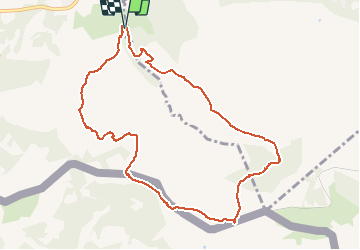
Trail On foot of 10.3 km to be discovered at New Aquitaine, Pyrénées-Atlantiques, Urrugne. This trail is proposed by marmotte65.

Description

Reco faite le 4/12/2019 avec J-c et M-j
Sortie autoroute Urrugne. Au rond point à l'entrée du village prendre la
direction d'Ibardin et aller vers Olhette continuer vers Ascain. a la sortie de Olhette
hôtel restaurant prendre le deuxième à D chemin de Xuruen-Borda
jusqu'au bout et se garer au parking sur la droite.
le PN pourra se prendre sur la frontière en dessous de la Rhune (s'il ni a pas de vent).
Ne as manquer le GR 10 pour la descente vers Olhette, et si tout se pase bien nous aurons passer une superbe journée.

Elevation profile

Positioning

Country:
France
Region :
New Aquitaine
Department/Province :
Pyrénées-Atlantiques
Municipality :
Urrugne
Location:
Unknown
Start:(UTM)
608660 ; 4798557 (30T) N.

Trails nearby

Trail Walking Ascain - ascain Sare ascain - Photo
Walking
RayFab

Walking

Medium
(1)
Ascain, New Aquitaine, Pyrénées-Atlantiques, France
18.8 km | 27 km-effort
4h 39min
Yes
Trail Walking Urrugne - Montagne de Ciboure - Trabenea - Photo
Walking
tracegps

Walking

Medium
(2)
Urrugne, New Aquitaine, Pyrénées-Atlantiques, France
8.6 km | 13.3 km-effort
2h 30min
Yes
Trail Walking Saint-Pée-sur-Nivelle - Uhartea 22   - Photo
Walking
tracegps

Walking

Very difficult
(1)
Saint-Pée-sur-Nivelle, New Aquitaine, Pyrénées-Atlantiques, France
22 km | 31 km-effort
7h 0min
Yes
Trail Walking Urrugne - rhune - Photo
Walking
phil331

Walking

Medium
(1)
Urrugne, New Aquitaine, Pyrénées-Atlantiques, France
11.9 km | 24 km-effort
4h 43min
Yes
Trail Mountain bike Urrugne - 64-Olhette-20110417 - Photo
Mountain bike
Gus64

Mountain bike

Difficult
(2)
Urrugne, New Aquitaine, Pyrénées-Atlantiques, France
33 km | 49 km-effort
3h 30min
Yes
Trail Walking Ascain - la rhune depuis olhette - Photo
Walking
jcaudron

Walking

Medium
(2)
Ascain, New Aquitaine, Pyrénées-Atlantiques, France
9.8 km | 20 km-effort
Unknown
Yes
Trail Walking Ascain - Ascain_Col St Ignace - Photo
Walking
viam19

Walking

Medium
(1)
Ascain, New Aquitaine, Pyrénées-Atlantiques, France
7 km | 9.3 km-effort
2h 6min
Yes
Trail Walking Urrugne - La Rhune en boucle - Photo
Walking
jaja64

Walking

Difficult
Urrugne, New Aquitaine, Pyrénées-Atlantiques, France
12.6 km | 24 km-effort
5h 29min
Yes
Trail Mountain bike Ascain - Ibardin 10/8/23 - Photo
Mountain bike
CEFAMALI

Mountain bike

Ascain, New Aquitaine, Pyrénées-Atlantiques, France
40 km | 58 km-effort
3h 52min
No


Close
My subscriptions