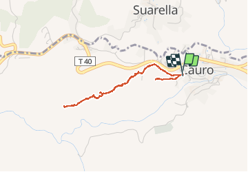
![](/images/other/stat-length.png)
![Trail Walking Cauro - Arche de CAURO - Photo](https://media.geolcdn.com/t/1900/400/cfdda6f2-c8ca-4324-a19a-1f89ae3de1fa.jpg&format=pjpeg&maxdim=2)
Arche de CAURO
cathymac20
User
![Length](/images/other/stat-length.png)
![Max alt](https://static1.geolcdn.com/siteimages/upload/files/1508320355ic_sort_altitude_max_24dp.png)
![Uphill gradient](https://static1.geolcdn.com/siteimages/upload/files/1508320355ic_sort_den_pos_24dp.png)
![Km-Effort](/images/other/stat-length.png)
![Min alt](https://static1.geolcdn.com/siteimages/upload/files/1508320355ic_sort_altitude_min_24dp.png)
![Downhill gradient](https://static1.geolcdn.com/siteimages/upload/files/1508320355ic_sort_den_neg_24dp.png)
![Boucle](https://static1.geolcdn.com/siteimages/upload/files/16400158638029165_repeat_loop_refresh_sync_direction_icon.png)
![Walking](https://static1.geolcdn.com/sitytour/trail-icons/101.png)
2h47
Difficulty : Easy
![Scan this QR Code to open this trail in the SityTrail application](https://capi.geolives.com/qq0zvz2zws4bq2lad0pu/sitytour/trails/2274519/qr.png?size=200)
FREE GPS app for hiking
About
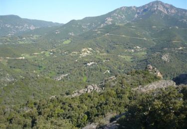
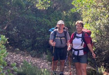
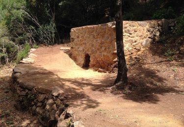
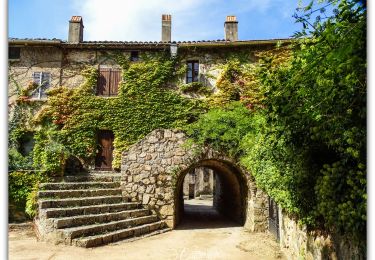
Trail Walking of 3.9 km to be discovered at Corsica, South Corsica, Cauro. This trail is proposed by cathymac20.
Description
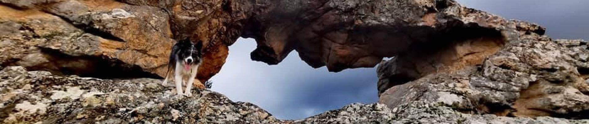
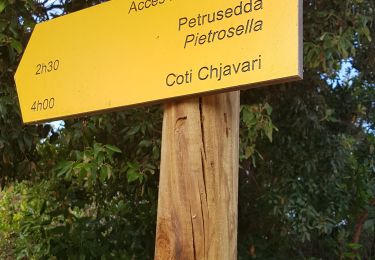
Une petite rando méconnue aux portes d'Ajaccio. Se garer à l'église de Cauro. C'est une balade très facile, pour rallonger un peu le parcours commencer ou finir par la croix en granit, prendre le chemin bétonné juste derrière l'église à gauche puis monter à droite au fond démarre un petit chemin, en 5 mn vous arriverez à cette jolie croix qui domine. Revenir sur ses pas jusqu'à l'église, prendre le chemin de terre parallèle à la route, puis à gauche, vous passez devant une résidence, aja di muro, continuer, vous aller arriver à un portail en fer d'une maison, un chemin à gauche s offre à vous, ce n est pas celui là... devant le portail de la maison prendre à droite un petit couloir qui longe la clôture, insistez, c'est bien là...vous traversez le petit champ, en face le chemin est cairné, en haut faire le crochet à droite pour aller vers le drapeau, il faut un peu s'aider de ses mains, une jolie vasque dans la roche un peu plus loin, redescendre et aller vers le bas, il y a des traces jaunes et des cairns regardez bien... admirez les roches plein de formes étranges à regarder... continuer longez un muret de pierres sèches, vous découvrirez l'arche au dernier moment. Je vous conseille de prolonger sur la montagne juste un peu plus loin à côté en marchant 5 mn de plus pour découvrir encore de belles roches et un panorama "plongeant". Revenir par le même chemin.
Positioning
Comments
Trails nearby
![Trail Mountain bike Cauro - vtt cauro accelasca piste ruppione et retour - Photo](https://media.geolcdn.com/t/375/260/7abe0afc-2a2f-49d5-bce1-60845f87f536.jpg&format=jpg&maxdim=2)
![Mountain bike Mountain bike](https://static1.geolcdn.com/sitytour/trail-icons/202.png)
Mountain bike
![](/images/other/stat-length.png)
![](https://static1.geolcdn.com/siteimages/upload/files/16400158638029165_repeat_loop_refresh_sync_direction_icon.png)
![Trail Walking Eccica-Suarella - Cauro, de Pian di veccia jusqu'au Prunu - Photo](https://media.geolcdn.com/t/375/260/ext.jpg?maxdim=2&url=https%3A%2F%2Fservices.sitytrail.com%2FGeolivesWS%2FDownloadMedia.ashx%3FTrailID%3D357559%26Media%3Dfix__20141027102804.jpg)
![Walking Walking](https://static1.geolcdn.com/sitytour/trail-icons/101.png)
Walking
![](/images/other/stat-length.png)
![](https://static1.geolcdn.com/siteimages/upload/files/16400158638029165_repeat_loop_refresh_sync_direction_icon.png)
![Trail Walking Grosseto-Prugna - Ma Mare a Mare centre étape 2: du col St Georges vers Quasquara - Photo](https://media.geolcdn.com/t/375/260/ext.jpg?maxdim=2&url=https%3A%2F%2Fservices.sitytrail.com%2FGeolivesWS%2FDownloadMedia.ashx%3FTrailID%3D339912%26Media%3D20140820144728.jpg)
![Walking Walking](https://static1.geolcdn.com/sitytour/trail-icons/101.png)
Walking
![](/images/other/stat-length.png)
![](https://static1.geolcdn.com/siteimages/upload/files/16400158638029165_repeat_loop_refresh_sync_direction_icon.png)
![Trail Running Eccica-Suarella - Trail de Sampiero - Photo](https://media.geolcdn.com/t/375/260/ext.jpg?maxdim=2&url=https%3A%2F%2Fservices.sitytrail.com%2FGeolivesWS%2FDownloadMedia.ashx%3FTrailID%3D102895%26Media%3D4145_5.jpg)
![Running Running](https://static1.geolcdn.com/sitytour/trail-icons/103.png)
Running
![](/images/other/stat-length.png)
![](https://static1.geolcdn.com/siteimages/upload/files/16400158638029165_repeat_loop_refresh_sync_direction_icon.png)
![Trail Walking Eccica-Suarella - Trail de Sampiero - Photo](https://media.geolcdn.com/t/375/260/ext.jpg?maxdim=2&url=https%3A%2F%2Fservices.sitytrail.com%2FGeolivesWS%2FDownloadMedia.ashx%3FTrailID%3D102894%26Media%3D4145_5.jpg)
![Walking Walking](https://static1.geolcdn.com/sitytour/trail-icons/101.png)
Walking
![](/images/other/stat-length.png)
![](https://static1.geolcdn.com/siteimages/upload/files/16400158638029165_repeat_loop_refresh_sync_direction_icon.png)
![Trail Walking Cauro - cauro col st Antoine - Photo](https://media.geolcdn.com/t/375/260/ext.jpg?maxdim=2&url=https%3A%2F%2Fstatic1.geolcdn.com%2Fsiteimages%2Fupload%2Ffiles%2F1553511878bg_sport_marche.png)
![Walking Walking](https://static1.geolcdn.com/sitytour/trail-icons/101.png)
Walking
![](/images/other/stat-length.png)
![](https://static1.geolcdn.com/siteimages/upload/files/16400158638029165_repeat_loop_refresh_sync_direction_icon.png)
![Trail Walking Grosseto-Prugna - Mar A Mar sixième jour - Photo](https://media.geolcdn.com/t/375/260/ccafab3f-6d1b-4179-a11c-90d55c183a6a.jpg&format=jpg&maxdim=2)
![Walking Walking](https://static1.geolcdn.com/sitytour/trail-icons/101.png)
Walking
![](/images/other/stat-length.png)
![](https://static1.geolcdn.com/siteimages/upload/files/16400158638029165_repeat_loop_refresh_sync_direction_icon.png)
![Trail On foot Cuttoli-Corticchiato - Monte Aragnascu - Photo](https://media.geolcdn.com/t/375/260/09bdb810-f606-41a8-b7cc-b48c994453eb.jpeg&format=jpg&maxdim=2)
![On foot On foot](https://static1.geolcdn.com/sitytour/trail-icons/100.png)
On foot
![](/images/other/stat-length.png)
![](https://static1.geolcdn.com/siteimages/upload/files/16400158638029165_repeat_loop_refresh_sync_direction_icon.png)
![Trail Walking Eccica-Suarella - Eccica Suarella - Photo](https://media.geolcdn.com/t/375/260/1068ed9f-44a4-4572-8414-66a82f5e345c.jpg&format=jpg&maxdim=2)
![Walking Walking](https://static1.geolcdn.com/sitytour/trail-icons/101.png)
Walking
![](/images/other/stat-length.png)
![](https://static1.geolcdn.com/siteimages/upload/files/16400158638029165_repeat_loop_refresh_sync_direction_icon.png)
La Rocca de Cauro, i compris l'arche sont des terrain privée, aucun chemin publique n'est autorisé, veillez retiré vos annonce sous peine de poursuite
top