![](/images/other/stat-length.png)
![Trail On foot Boissy-Saint-Léger - Rando 6 km en forêt de Grosbois - Photo](https://media.geolcdn.com/t/1900/400/ext.pjpeg?maxdim=2&url=https%3A%2F%2Fstatic1.geolcdn.com%2Fsiteimages%2Fupload%2Ffiles%2F1545311037marcheuse_200dpi.jpg)
Rando 6 km en forêt de Grosbois
Surot
User
![Length](/images/other/stat-length.png)
Length
6.3 km
![Max alt](https://static1.geolcdn.com/siteimages/upload/files/1508320355ic_sort_altitude_max_24dp.png)
Max alt
101 m
![Uphill gradient](https://static1.geolcdn.com/siteimages/upload/files/1508320355ic_sort_den_pos_24dp.png)
Uphill gradient
32 m
![Km-Effort](/images/other/stat-length.png)
Km-Effort
6.7 km
![Min alt](https://static1.geolcdn.com/siteimages/upload/files/1508320355ic_sort_altitude_min_24dp.png)
Min alt
89 m
![Downhill gradient](https://static1.geolcdn.com/siteimages/upload/files/1508320355ic_sort_den_neg_24dp.png)
Downhill gradient
32 m
![Boucle](https://static1.geolcdn.com/siteimages/upload/files/16400158638029165_repeat_loop_refresh_sync_direction_icon.png)
Boucle
Yes
Creation date :
2019-11-24 16:11:00.497
Updated on :
2019-11-24 16:15:41.352
![On foot](https://static1.geolcdn.com/sitytour/trail-icons/100.png)
2h05
Difficulty : Easy
![Scan this QR Code to open this trail in the SityTrail application](https://capi.geolives.com/qq0zvz2zws4bq2lad0pu/sitytour/trails/2271243/qr.png?size=200)
FREE GPS app for hiking
About
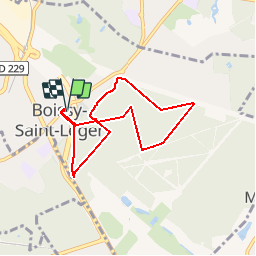
Trail On foot of 6.3 km to be discovered at Ile-de-France, Val-de-Marne, Boissy-Saint-Léger. This trail is proposed by Surot.
Description
Boucle facile sans dénivelé dans cette jolie forêt avec un passage près des ruchers et parking près du marché. Bien surtout pour rando douce et/ou santé.
Positioning
Country:
France
Region :
Ile-de-France
Department/Province :
Val-de-Marne
Municipality :
Boissy-Saint-Léger
Location:
Unknown
Start:(Dec)
Start:(UTM)
464269 ; 5399655 (31U) N.
Comments
Trails nearby
![Trail Walking Chennevières-sur-Marne - J 18 12 km Pont de Chennevières - Photo](https://media.geolcdn.com/t/375/260/6347577b-7c01-4d78-a0ab-c4e201132c35.jpg&format=jpg&maxdim=2)
![Walking Walking](https://static1.geolcdn.com/sitytour/trail-icons/101.png)
J 18 12 km Pont de Chennevières
Walking
Medium
(5)
Chennevières-sur-Marne,
Ile-de-France,
Val-de-Marne,
France
![](/images/other/stat-length.png)
11 km | 12 km-effort
2h 42min
![](https://static1.geolcdn.com/siteimages/upload/files/16400158638029165_repeat_loop_refresh_sync_direction_icon.png)
Yes
![Trail On foot Marolles-en-Brie - L 48 Les Bagaudes et parcours sportif de Sucy 5,7 km - Photo](https://media.geolcdn.com/t/375/260/ext.jpg?maxdim=2&url=https%3A%2F%2Fstatic1.geolcdn.com%2Fsiteimages%2Fupload%2Ffiles%2F1545311037marcheuse_200dpi.jpg)
![On foot On foot](https://static1.geolcdn.com/sitytour/trail-icons/100.png)
L 48 Les Bagaudes et parcours sportif de Sucy 5,7 km
On foot
Very easy
(5)
Marolles-en-Brie,
Ile-de-France,
Val-de-Marne,
France
![](/images/other/stat-length.png)
6 km | 6.6 km-effort
1h 29min
![](https://static1.geolcdn.com/siteimages/upload/files/16400158638029165_repeat_loop_refresh_sync_direction_icon.png)
Yes
![Trail On foot Villecresnes - L 20 boucle golf villecresnes et ancienne voie de chemin de fer - Photo](https://media.geolcdn.com/t/375/260/ext.jpg?maxdim=2&url=https%3A%2F%2Fstatic1.geolcdn.com%2Fsiteimages%2Fupload%2Ffiles%2F1545311037marcheuse_200dpi.jpg)
![On foot On foot](https://static1.geolcdn.com/sitytour/trail-icons/100.png)
L 20 boucle golf villecresnes et ancienne voie de chemin de fer
On foot
Very easy
(6)
Villecresnes,
Ile-de-France,
Val-de-Marne,
France
![](/images/other/stat-length.png)
6.5 km | 7.7 km-effort
1h 44min
![](https://static1.geolcdn.com/siteimages/upload/files/16400158638029165_repeat_loop_refresh_sync_direction_icon.png)
Yes
![Trail Walking Marolles-en-Brie - GRP CV-IDF 05 - Photo](https://media.geolcdn.com/t/375/260/3f1bdad2-a959-4f32-b201-59b2c8841688.jpg&format=jpg&maxdim=2)
![Walking Walking](https://static1.geolcdn.com/sitytour/trail-icons/101.png)
GRP CV-IDF 05
Walking
Difficult
(1)
Marolles-en-Brie,
Ile-de-France,
Val-de-Marne,
France
![](/images/other/stat-length.png)
13.5 km | 15.2 km-effort
3h 27min
![](https://static1.geolcdn.com/siteimages/upload/files/16400158638029165_repeat_loop_refresh_sync_direction_icon.png)
No
![Trail Walking Mandres-les-Roses - J 26 Mandres, Boussy , Brunoy le chemin des fresques - Photo](https://media.geolcdn.com/t/375/260/a7099e05-5a69-431c-83ab-49f9701f5dd5.jpg&format=jpg&maxdim=2)
![Walking Walking](https://static1.geolcdn.com/sitytour/trail-icons/101.png)
J 26 Mandres, Boussy , Brunoy le chemin des fresques
Walking
Medium
(2)
Mandres-les-Roses,
Ile-de-France,
Val-de-Marne,
France
![](/images/other/stat-length.png)
12.2 km | 13.8 km-effort
3h 7min
![](https://static1.geolcdn.com/siteimages/upload/files/16400158638029165_repeat_loop_refresh_sync_direction_icon.png)
Yes
![Trail Walking Noiseau - depuis Noiseau - Photo](https://media.geolcdn.com/t/375/260/ext.jpg?maxdim=2&url=https%3A%2F%2Fservices.sitytrail.com%2FGeolivesWS%2FDownloadMedia.ashx%3FTrailID%3D169363%26Media%3D20130109131150.jpeg)
![Walking Walking](https://static1.geolcdn.com/sitytour/trail-icons/101.png)
depuis Noiseau
Walking
Easy
(2)
Noiseau,
Ile-de-France,
Val-de-Marne,
France
![](/images/other/stat-length.png)
17 km | 19.1 km-effort
4h 35min
![](https://static1.geolcdn.com/siteimages/upload/files/16400158638029165_repeat_loop_refresh_sync_direction_icon.png)
Yes
![Trail Walking Yerres - BM Foret Regionale de Grobois 10km - Photo](https://media.geolcdn.com/t/375/260/ext.jpg?maxdim=2&url=https%3A%2F%2Fstatic1.geolcdn.com%2Fsiteimages%2Fupload%2Ffiles%2F1553511878bg_sport_marche.png)
![Walking Walking](https://static1.geolcdn.com/sitytour/trail-icons/101.png)
BM Foret Regionale de Grobois 10km
Walking
Medium
(1)
Yerres,
Ile-de-France,
Essonne,
France
![](/images/other/stat-length.png)
10.4 km | 11 km-effort
2h 30min
![](https://static1.geolcdn.com/siteimages/upload/files/16400158638029165_repeat_loop_refresh_sync_direction_icon.png)
Yes
![Trail Walking Yerres - BM Foret Regionale Grosbois 10km - Photo](https://media.geolcdn.com/t/375/260/ext.jpg?maxdim=2&url=https%3A%2F%2Fstatic1.geolcdn.com%2Fsiteimages%2Fupload%2Ffiles%2F1553511878bg_sport_marche.png)
![Walking Walking](https://static1.geolcdn.com/sitytour/trail-icons/101.png)
BM Foret Regionale Grosbois 10km
Walking
Medium
(1)
Yerres,
Ile-de-France,
Essonne,
France
![](/images/other/stat-length.png)
9.8 km | 10.5 km-effort
2h 23min
![](https://static1.geolcdn.com/siteimages/upload/files/16400158638029165_repeat_loop_refresh_sync_direction_icon.png)
Yes
![Trail Walking Yerres - J 43 Yerres Parc Caillebotte, île des Prévôts - Photo](https://media.geolcdn.com/t/375/260/3326873b-9942-4059-9e6b-fa272d49fbc4.jpg&format=jpg&maxdim=2)
![Walking Walking](https://static1.geolcdn.com/sitytour/trail-icons/101.png)
J 43 Yerres Parc Caillebotte, île des Prévôts
Walking
Medium
(4)
Yerres,
Ile-de-France,
Essonne,
France
![](/images/other/stat-length.png)
11.4 km | 13.1 km-effort
2h 59min
![](https://static1.geolcdn.com/siteimages/upload/files/16400158638029165_repeat_loop_refresh_sync_direction_icon.png)
Yes