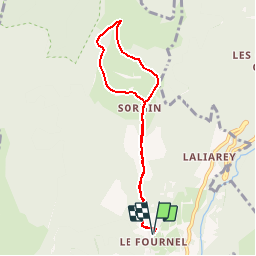
![](/images/other/stat-length.png)
![Trail Snowshoes Engins - Le Plateau de Sornin depuis Le Fournel - Photo](https://media.geolcdn.com/t/1900/400/ext.pjpeg?maxdim=2&url=https%3A%2F%2Fstatic1.geolcdn.com%2Fsiteimages%2Fupload%2Ffiles%2F1524743153raquette.jpg)
Le Plateau de Sornin depuis Le Fournel
phidge
User
![Length](/images/other/stat-length.png)
![Max alt](https://static1.geolcdn.com/siteimages/upload/files/1508320355ic_sort_altitude_max_24dp.png)
![Uphill gradient](https://static1.geolcdn.com/siteimages/upload/files/1508320355ic_sort_den_pos_24dp.png)
![Km-Effort](/images/other/stat-length.png)
![Min alt](https://static1.geolcdn.com/siteimages/upload/files/1508320355ic_sort_altitude_min_24dp.png)
![Downhill gradient](https://static1.geolcdn.com/siteimages/upload/files/1508320355ic_sort_den_neg_24dp.png)
![Boucle](https://static1.geolcdn.com/siteimages/upload/files/16400158638029165_repeat_loop_refresh_sync_direction_icon.png)
![Snowshoes](https://static1.geolcdn.com/sitytour/trail-icons/504.png)
--
Difficulty : Medium
![Scan this QR Code to open this trail in the SityTrail application](https://capi.geolives.com/qq0zvz2zws4bq2lad0pu/sitytour/trails/2270142/qr.png?size=200)
FREE GPS app for hiking
About
Trail Snowshoes of 7.1 km to be discovered at Auvergne-Rhône-Alpes, Isère, Engins. This trail is proposed by phidge.
Description
Copié sur Visorando
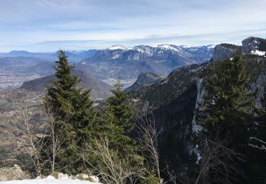
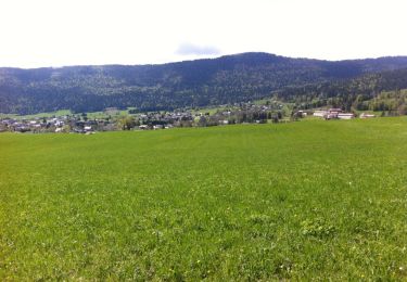
Très agréable promenade sur un plateau fort connu des Grenoblois et qui s'apprécie en toutes saisons.
Description de la randonnée
Stationner au hameau du Fournel sur la commune d'Engins, parking de droite après le point de retournement (D/A) Démarrer en face par la route goudronnée en forte déclivité avant de retrouver le large sentier.
(1) L'emprunter à droite plein Nord, ce sentier dessert l'alpage du plateau. Rester sur cette piste balisée aux couleurs du Vercors, c'est à dire JV (Jaune Vert) avant de parvenir au hameau d'alpage de Sornin.
(2) S'orienter alors Nord-Nord-Est puis, avant la lisière du bois, Nord Ouest. Contourner le bois et, à son extrémité Ouest, apercevoir la Cabane du Berger. Continuer jusqu'à la cabane.
(3) Changer de direction et par Sud-Ouest, traverser le bois de feuillus. Déboucher dans un alpage, prolonger Sud jusqu'à atteindre une barre rocheuse.
(4) Contourner cette barre par la gauche et parvenir aux chalets de Sornin.
(2) Reprendre alors le trajet aller pour revenir sans difficulté au parking du Fournel (D/A).
.
Positioning
Comments
Trails nearby
![Trail Walking Sassenage - La ferme Durand - Photo](https://media.geolcdn.com/t/375/260/94c22489-8db0-4cec-b019-90eab5ac0fa3.jpg&format=jpg&maxdim=2)
![Walking Walking](https://static1.geolcdn.com/sitytour/trail-icons/101.png)
Walking
![](/images/other/stat-length.png)
![](https://static1.geolcdn.com/siteimages/upload/files/16400158638029165_repeat_loop_refresh_sync_direction_icon.png)
![Trail Nordic walking Sassenage - Parc de l'Ovalie - Noyarey - Photo](https://media.geolcdn.com/t/375/260/d032ba44-c97c-4141-ba1d-c30342d72d38.jpg&format=jpg&maxdim=2)
![Nordic walking Nordic walking](https://static1.geolcdn.com/sitytour/trail-icons/102.png)
Nordic walking
![](/images/other/stat-length.png)
![](https://static1.geolcdn.com/siteimages/upload/files/16400158638029165_repeat_loop_refresh_sync_direction_icon.png)
![Trail Nordic walking Seyssins - Seyssins le haut - Les Arcelles dans la neige - Photo](https://media.geolcdn.com/t/375/260/09832c62-e152-4e15-aea9-389ff5328b66.jpg&format=jpg&maxdim=2)
![Nordic walking Nordic walking](https://static1.geolcdn.com/sitytour/trail-icons/102.png)
Nordic walking
![](/images/other/stat-length.png)
![](https://static1.geolcdn.com/siteimages/upload/files/16400158638029165_repeat_loop_refresh_sync_direction_icon.png)
![Trail Walking Engins - Circuit pas de la Lose, du Tracollet, de l'Ours avec un retour par le passage de la Grande Combe - Photo](https://media.geolcdn.com/t/375/260/e578919b-c81c-4fe4-99cc-8260409f6f79.jpg&format=jpg&maxdim=2)
![Walking Walking](https://static1.geolcdn.com/sitytour/trail-icons/101.png)
Walking
![](/images/other/stat-length.png)
![](https://static1.geolcdn.com/siteimages/upload/files/16400158638029165_repeat_loop_refresh_sync_direction_icon.png)
![Trail Walking Seyssins - MOUCHEROTTE - Photo](https://media.geolcdn.com/t/375/260/fbc259ea-06fa-4a05-83ef-656dc650e275.jpg&format=jpg&maxdim=2)
![Walking Walking](https://static1.geolcdn.com/sitytour/trail-icons/101.png)
Walking
![](/images/other/stat-length.png)
![](https://static1.geolcdn.com/siteimages/upload/files/16400158638029165_repeat_loop_refresh_sync_direction_icon.png)
![Trail Snowshoes Autrans-Méaudre en Vercors - Autrans: Gève - Bec de l'Orient - Photo](https://media.geolcdn.com/t/375/260/4e878d82-c145-4502-8e75-629fc9885006.jpg&format=jpg&maxdim=2)
![Snowshoes Snowshoes](https://static1.geolcdn.com/sitytour/trail-icons/504.png)
Snowshoes
![](/images/other/stat-length.png)
![](https://static1.geolcdn.com/siteimages/upload/files/16400158638029165_repeat_loop_refresh_sync_direction_icon.png)
![Trail Snowshoes Lans-en-Vercors - Charande, La Molière par les Aigaux - Photo](https://media.geolcdn.com/t/375/260/ext.jpg?maxdim=2&url=https%3A%2F%2Fservices.sitytrail.com%2FGeolivesWS%2FDownloadMedia.ashx%3FTrailID%3D518560%26Media%3Dfix__20160128112605.jpg)
![Snowshoes Snowshoes](https://static1.geolcdn.com/sitytour/trail-icons/504.png)
Snowshoes
![](/images/other/stat-length.png)
![](https://static1.geolcdn.com/siteimages/upload/files/16400158638029165_repeat_loop_refresh_sync_direction_icon.png)
![Trail Walking Autrans-Méaudre en Vercors - Autrans : Pas de l'Ours - Photo](https://media.geolcdn.com/t/375/260/ext.jpg?maxdim=2&url=https%3A%2F%2Fservices.sitytrail.com%2FGeolivesWS%2FDownloadMedia.ashx%3FTrailID%3D419322%26Media%3D20150509154225.jpg)
![Walking Walking](https://static1.geolcdn.com/sitytour/trail-icons/101.png)
Walking
![](/images/other/stat-length.png)
![](https://static1.geolcdn.com/siteimages/upload/files/16400158638029165_repeat_loop_refresh_sync_direction_icon.png)
![Trail Walking Saint-Nizier-du-Moucherotte - GTV - Tour du Vercors à pied - Saint Nizier du Moucherotte - Les Cochettes - Photo](https://media.geolcdn.com/t/375/260/ext.jpg?maxdim=2&url=https%3A%2F%2Fservices.sitytrail.com%2FGeolivesWS%2FDownloadMedia.ashx%3FTrailID%3D112634%26Media%3D11310_2.jpg)
![Walking Walking](https://static1.geolcdn.com/sitytour/trail-icons/101.png)
Walking
![](/images/other/stat-length.png)
![](https://static1.geolcdn.com/siteimages/upload/files/16400158638029165_repeat_loop_refresh_sync_direction_icon.png)