


Fez

jcm17
User
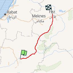

Length
258 km

Max alt
1687 m

Uphill gradient
3202 m
Km-Effort
301 km

Min alt
380 m

Downhill gradient
3333 m
Boucle
No
Creation date :
2019-11-19 12:34:42.167
Updated on :
2019-11-21 07:01:48.719
5h43
Difficulty : Very easy

FREE GPS app for hiking
 SityTrail
IGN / Geographical institutes
SityTrail World
The world is yours!
About
Trail Walking of 258 km to be discovered at Béni Mellal-Khénifra, Pachalik de Kasba Tadla, Kasba Tadla. This trail is proposed by jcm17.
Positioning
Country:
Morocco
Region :
Béni Mellal-Khénifra
Department/Province :
Pachalik de Kasba Tadla
Municipality :
Kasba Tadla
Location:
Unknown
Start:(Dec)
Start:(UTM)
757867 ; 3608336 (29S) N.
Comments
Trails nearby