![](/images/other/stat-length.png)
![Trail On foot Louvie-Juzon - LOUVIE JUZON Les tourbieres d arrudy-fait-458M+- - Photo](https://media.geolcdn.com/t/1900/400/ext.pjpeg?maxdim=2&url=https%3A%2F%2Fstatic1.geolcdn.com%2Fsiteimages%2Fupload%2Ffiles%2F1545311037marcheuse_200dpi.jpg)
LOUVIE JUZON Les tourbieres d arrudy-fait-458M+-
marmotte65
User GUIDE
![Length](/images/other/stat-length.png)
Length
11.7 km
![Max alt](https://static1.geolcdn.com/siteimages/upload/files/1508320355ic_sort_altitude_max_24dp.png)
Max alt
584 m
![Uphill gradient](https://static1.geolcdn.com/siteimages/upload/files/1508320355ic_sort_den_pos_24dp.png)
Uphill gradient
349 m
![Km-Effort](/images/other/stat-length.png)
Km-Effort
16.4 km
![Min alt](https://static1.geolcdn.com/siteimages/upload/files/1508320355ic_sort_altitude_min_24dp.png)
Min alt
376 m
![Downhill gradient](https://static1.geolcdn.com/siteimages/upload/files/1508320355ic_sort_den_neg_24dp.png)
Downhill gradient
350 m
![Boucle](https://static1.geolcdn.com/siteimages/upload/files/16400158638029165_repeat_loop_refresh_sync_direction_icon.png)
Boucle
Yes
Creation date :
2019-11-17 09:30:42.97
Updated on :
2022-04-06 08:25:52.06
![On foot](https://static1.geolcdn.com/sitytour/trail-icons/100.png)
3h52
Difficulty : Easy
![Scan this QR Code to open this trail in the SityTrail application](https://capi.geolives.com/qq0zvz2zws4bq2lad0pu/sitytour/trails/2266009/qr.png?size=200)
FREE GPS app for hiking
About
Trail On foot of 11.7 km to be discovered at New Aquitaine, Pyrénées-Atlantiques, Louvie-Juzon. This trail is proposed by marmotte65.
Description
Les tourbières de Louvie revue et corrigées.
2 possibilités sur cette trace.
Au départ :Soit on part directement vers l'église et on raccourcie de 0.6 km.
Soit on suit la trace vers le cimetiere et on ne monte pas au calvaire , et là on économise 1.3 km
Positioning
Country:
France
Region :
New Aquitaine
Department/Province :
Pyrénées-Atlantiques
Municipality :
Louvie-Juzon
Location:
Unknown
Start:(Dec)
Start:(UTM)
710020 ; 4773494 (30T) N.
Comments
Trails nearby
![Trail Walking Louvie-Juzon - Soum de las Picarras Montagne du Rey - Photo](https://media.geolcdn.com/t/375/260/ext.jpg?maxdim=2&url=https%3A%2F%2Fservices.sitytrail.com%2FGeolivesWS%2FDownloadMedia.ashx%3FTrailID%3D541294%26Media%3Dfix__20160320134039.jpg)
![Walking Walking](https://static1.geolcdn.com/sitytour/trail-icons/101.png)
Soum de las Picarras Montagne du Rey
Walking
Easy
(1)
Louvie-Juzon,
New Aquitaine,
Pyrénées-Atlantiques,
France
![](/images/other/stat-length.png)
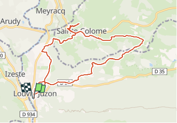
12.2 km | 25 km-effort
5h 16min
![](https://static1.geolcdn.com/siteimages/upload/files/16400158638029165_repeat_loop_refresh_sync_direction_icon.png)
Yes
![Trail Walking Bielle - BIELLE l arriu Mage reco 3443541 - Photo](https://media.geolcdn.com/t/375/260/85ef7966-54fd-44d2-aeee-6b5bc4ac7165.jpg&format=jpg&maxdim=2)
![Walking Walking](https://static1.geolcdn.com/sitytour/trail-icons/101.png)
BIELLE l arriu Mage reco 3443541
Walking
Difficult
Bielle,
New Aquitaine,
Pyrénées-Atlantiques,
France
![](/images/other/stat-length.png)
8.7 km | 14.7 km-effort
2h 47min
![](https://static1.geolcdn.com/siteimages/upload/files/16400158638029165_repeat_loop_refresh_sync_direction_icon.png)
Yes
![Trail On foot Bielle - L'Arriu-Mage - Photo](https://media.geolcdn.com/t/375/260/9d640f1d-cca3-4d6c-b124-0b8f06a68e5a.jpeg&format=jpg&maxdim=2)
![On foot On foot](https://static1.geolcdn.com/sitytour/trail-icons/100.png)
L'Arriu-Mage
On foot
Easy
Bielle,
New Aquitaine,
Pyrénées-Atlantiques,
France
![](/images/other/stat-length.png)
8 km | 14 km-effort
3h 10min
![](https://static1.geolcdn.com/siteimages/upload/files/16400158638029165_repeat_loop_refresh_sync_direction_icon.png)
Yes
![Trail On foot Bilhères - Les cercles de pierre (Bilhères) - Photo](https://media.geolcdn.com/t/375/260/d1f3f786-1fe8-47a8-af2d-8ff90104ea03.jpeg&format=jpg&maxdim=2)
![On foot On foot](https://static1.geolcdn.com/sitytour/trail-icons/100.png)
Les cercles de pierre (Bilhères)
On foot
Easy
Bilhères,
New Aquitaine,
Pyrénées-Atlantiques,
France
![](/images/other/stat-length.png)
7.2 km | 11.6 km-effort
2h 37min
![](https://static1.geolcdn.com/siteimages/upload/files/16400158638029165_repeat_loop_refresh_sync_direction_icon.png)
Yes
![Trail On foot Bilhères - Les cabanes de Lasbordes - Photo](https://media.geolcdn.com/t/375/260/6d402dc4-6faf-449a-b98e-9a6932ddd2f6.jpeg&format=jpg&maxdim=2)
![On foot On foot](https://static1.geolcdn.com/sitytour/trail-icons/100.png)
Les cabanes de Lasbordes
On foot
Easy
Bilhères,
New Aquitaine,
Pyrénées-Atlantiques,
France
![](/images/other/stat-length.png)
11.2 km | 19.7 km-effort
4h 28min
![](https://static1.geolcdn.com/siteimages/upload/files/16400158638029165_repeat_loop_refresh_sync_direction_icon.png)
Yes
![Trail On foot Louvie-Juzon - Le piémont du Rey - Photo](https://media.geolcdn.com/t/375/260/f491a556-8ecd-4525-a2fc-b2b6d591e533.jpeg&format=jpg&maxdim=2)
![On foot On foot](https://static1.geolcdn.com/sitytour/trail-icons/100.png)
Le piémont du Rey
On foot
Easy
Louvie-Juzon,
New Aquitaine,
Pyrénées-Atlantiques,
France
![](/images/other/stat-length.png)
3.5 km | 10.2 km-effort
2h 19min
![](https://static1.geolcdn.com/siteimages/upload/files/16400158638029165_repeat_loop_refresh_sync_direction_icon.png)
No
![Trail On foot Arudy - Le tour du bassin d'Arudy - Photo](https://media.geolcdn.com/t/375/260/f77d5769-a1f2-499c-9920-96e8d227d4fb.jpeg&format=jpg&maxdim=2)
![On foot On foot](https://static1.geolcdn.com/sitytour/trail-icons/100.png)
Le tour du bassin d'Arudy
On foot
Medium
Arudy,
New Aquitaine,
Pyrénées-Atlantiques,
France
![](/images/other/stat-length.png)
19.2 km | 27 km-effort
6h 7min
![](https://static1.geolcdn.com/siteimages/upload/files/16400158638029165_repeat_loop_refresh_sync_direction_icon.png)
Yes
![Trail On foot Sainte-Colome - Les buis - Photo](https://media.geolcdn.com/t/375/260/4276e983-4156-4966-8238-f2764987fcc4.jpeg&format=jpg&maxdim=2)
![On foot On foot](https://static1.geolcdn.com/sitytour/trail-icons/100.png)
Les buis
On foot
Easy
Sainte-Colome,
New Aquitaine,
Pyrénées-Atlantiques,
France
![](/images/other/stat-length.png)
6.1 km | 8.8 km-effort
2h 0min
![](https://static1.geolcdn.com/siteimages/upload/files/16400158638029165_repeat_loop_refresh_sync_direction_icon.png)
Yes
![Trail On foot Bilhères - Le Turon de Técouère - Photo](https://media.geolcdn.com/t/375/260/b6cd5576-3b7b-4d3a-b695-7d81816e4fdf.jpeg&format=jpg&maxdim=2)
![On foot On foot](https://static1.geolcdn.com/sitytour/trail-icons/100.png)
Le Turon de Técouère
On foot
Easy
Bilhères,
New Aquitaine,
Pyrénées-Atlantiques,
France
![](/images/other/stat-length.png)
6.3 km | 7.9 km-effort
1h 47min
![](https://static1.geolcdn.com/siteimages/upload/files/16400158638029165_repeat_loop_refresh_sync_direction_icon.png)
Yes