![](/images/other/stat-length.png)
![Trail Walking Mont-Vully - A la decouverte du chemin viticole - Photo](https://media.geolcdn.com/t/1900/400/ext.pjpeg?maxdim=2&url=https%3A%2F%2Fstatic1.geolcdn.com%2Fsiteimages%2Fupload%2Ffiles%2F1553511878bg_sport_marche.png)
A la decouverte du chemin viticole
libellule1950
User
![Length](/images/other/stat-length.png)
Length
5.5 km
![Max alt](https://static1.geolcdn.com/siteimages/upload/files/1508320355ic_sort_altitude_max_24dp.png)
Max alt
518 m
![Uphill gradient](https://static1.geolcdn.com/siteimages/upload/files/1508320355ic_sort_den_pos_24dp.png)
Uphill gradient
168 m
![Km-Effort](/images/other/stat-length.png)
Km-Effort
7.7 km
![Min alt](https://static1.geolcdn.com/siteimages/upload/files/1508320355ic_sort_altitude_min_24dp.png)
Min alt
427 m
![Downhill gradient](https://static1.geolcdn.com/siteimages/upload/files/1508320355ic_sort_den_neg_24dp.png)
Downhill gradient
168 m
![Boucle](https://static1.geolcdn.com/siteimages/upload/files/16400158638029165_repeat_loop_refresh_sync_direction_icon.png)
Boucle
No
Creation date :
2014-12-11 00:00:00.0
Updated on :
2014-12-11 00:00:00.0
![Walking](https://static1.geolcdn.com/sitytour/trail-icons/101.png)
--
Difficulty : Unknown
![Scan this QR Code to open this trail in the SityTrail application](https://capi.geolives.com/qq0zvz2zws4bq2lad0pu/sitytour/trails/22625/qr.png?size=200)
FREE GPS app for hiking
About
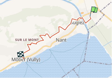
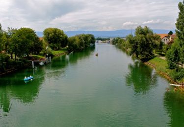
Trail Walking of 5.5 km to be discovered at Fribourg, See District, Mont-Vully. This trail is proposed by libellule1950.
Description
Chemin viticole avec panneaux explicatifs.
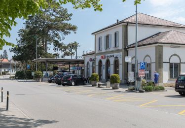
Départ de la gare de Sugiez et arrivée à Môtier.
Pour le retour, possibilité de prendre le bateau ou de revenir à pied par le chemin de rive du Lac.
Positioning
Country:
Switzerland
Region :
Fribourg
Department/Province :
See District
Municipality :
Mont-Vully
Location:
Unknown
Start:(Dec)
Start:(UTM)
356949 ; 5202865 (32T) N.
Comments
Trails nearby
![Trail On foot Murten - Murten/Station - Oberburg - Photo](https://media.geolcdn.com/t/375/260/7b5a57d2-dc68-4e28-933e-c9afebbd22d0.jpeg&format=jpg&maxdim=2)
![On foot On foot](https://static1.geolcdn.com/sitytour/trail-icons/100.png)
Murten/Station - Oberburg
On foot
Easy
Murten,
Fribourg,
See District,
Switzerland
![](/images/other/stat-length.png)
3.6 km | 4.6 km-effort
1h 2min
![](https://static1.geolcdn.com/siteimages/upload/files/16400158638029165_repeat_loop_refresh_sync_direction_icon.png)
No
![Trail On foot Murten - Schlacht-Denkmal - fixme - Photo](https://media.geolcdn.com/t/375/260/2f05b743-547d-4a06-ab39-0bedb40d7565.jpeg&format=jpg&maxdim=2)
![On foot On foot](https://static1.geolcdn.com/sitytour/trail-icons/100.png)
Schlacht-Denkmal - fixme
On foot
Easy
Murten,
Fribourg,
See District,
Switzerland
![](/images/other/stat-length.png)
6.7 km | 7.2 km-effort
1h 38min
![](https://static1.geolcdn.com/siteimages/upload/files/16400158638029165_repeat_loop_refresh_sync_direction_icon.png)
No
![Trail On foot Murten - Oberburg - Ulmiz - Photo](https://media.geolcdn.com/t/375/260/e06f2607-8305-4b7f-9ea2-d466116d8e5c.jpeg&format=jpg&maxdim=2)
![On foot On foot](https://static1.geolcdn.com/sitytour/trail-icons/100.png)
Oberburg - Ulmiz
On foot
Easy
Murten,
Fribourg,
See District,
Switzerland
![](/images/other/stat-length.png)
5 km | 6.4 km-effort
1h 26min
![](https://static1.geolcdn.com/siteimages/upload/files/16400158638029165_repeat_loop_refresh_sync_direction_icon.png)
No
![Trail On foot Murten - Murten/Station - fixme - Photo](https://media.geolcdn.com/t/375/260/7b5a57d2-dc68-4e28-933e-c9afebbd22d0.jpeg&format=jpg&maxdim=2)
![On foot On foot](https://static1.geolcdn.com/sitytour/trail-icons/100.png)
Murten/Station - fixme
On foot
Easy
Murten,
Fribourg,
See District,
Switzerland
![](/images/other/stat-length.png)
4 km | 5.2 km-effort
1h 11min
![](https://static1.geolcdn.com/siteimages/upload/files/16400158638029165_repeat_loop_refresh_sync_direction_icon.png)
No
![Trail On foot Murten - Murten Schiffstation – Sugiez gare - Photo](https://media.geolcdn.com/t/375/260/bce25202-3fb9-458c-97af-8a42084ae3d2.jpeg&format=jpg&maxdim=2)
![On foot On foot](https://static1.geolcdn.com/sitytour/trail-icons/100.png)
Murten Schiffstation – Sugiez gare
On foot
Easy
Murten,
Fribourg,
See District,
Switzerland
![](/images/other/stat-length.png)
5.1 km | 5.7 km-effort
1h 18min
![](https://static1.geolcdn.com/siteimages/upload/files/16400158638029165_repeat_loop_refresh_sync_direction_icon.png)
No
![Trail On foot Mont-Vully - Mont Vully – La Sauge - Photo](https://media.geolcdn.com/t/375/260/9207a43f-b48b-4328-8e14-7ef88c3e74da.jpeg&format=jpg&maxdim=2)
![On foot On foot](https://static1.geolcdn.com/sitytour/trail-icons/100.png)
Mont Vully – La Sauge
On foot
Easy
Mont-Vully,
Fribourg,
See District,
Switzerland
![](/images/other/stat-length.png)
4.5 km | 5.5 km-effort
1h 14min
![](https://static1.geolcdn.com/siteimages/upload/files/16400158638029165_repeat_loop_refresh_sync_direction_icon.png)
No
![Trail On foot Cudrefin - La Sauge – Cudrefin - Photo](https://media.geolcdn.com/t/375/260/7a6f0435-2455-414c-b5b8-29e6bd8f1327.jpeg&format=jpg&maxdim=2)
![On foot On foot](https://static1.geolcdn.com/sitytour/trail-icons/100.png)
La Sauge – Cudrefin
On foot
Easy
Cudrefin,
Vaud,
District de la Broye-Vully,
Switzerland
![](/images/other/stat-length.png)
3.9 km | 4.3 km-effort
59min
![](https://static1.geolcdn.com/siteimages/upload/files/16400158638029165_repeat_loop_refresh_sync_direction_icon.png)
No
![Trail On foot Murten - Murten/Station - Salvenach - Photo](https://media.geolcdn.com/t/375/260/c1125570-33d5-4f63-99cd-9b3c44278b45.jpeg&format=jpg&maxdim=2)
![On foot On foot](https://static1.geolcdn.com/sitytour/trail-icons/100.png)
Murten/Station - Salvenach
On foot
Easy
Murten,
Fribourg,
See District,
Switzerland
![](/images/other/stat-length.png)
4.5 km | 5.9 km-effort
1h 20min
![](https://static1.geolcdn.com/siteimages/upload/files/16400158638029165_repeat_loop_refresh_sync_direction_icon.png)
No
![Trail On foot Murten - resSchlacht-Denkmal - Clavaleyer - Photo](https://media.geolcdn.com/t/375/260/477ffe7b-71d6-4c3c-9417-f29a812a09d8.jpeg&format=jpg&maxdim=2)
![On foot On foot](https://static1.geolcdn.com/sitytour/trail-icons/100.png)
resSchlacht-Denkmal - Clavaleyer
On foot
Easy
Murten,
Fribourg,
See District,
Switzerland
![](/images/other/stat-length.png)
3.4 km | 3.9 km-effort
52min
![](https://static1.geolcdn.com/siteimages/upload/files/16400158638029165_repeat_loop_refresh_sync_direction_icon.png)
No