![](/images/other/stat-length.png)
![Trail On foot Dinant - Furfooz-Wazin-Furfooz - Photo](https://media.geolcdn.com/t/1900/400/ext.pjpeg?maxdim=2&url=https%3A%2F%2Fstatic1.geolcdn.com%2Fsiteimages%2Fupload%2Ffiles%2F1545311037marcheuse_200dpi.jpg)
Furfooz-Wazin-Furfooz
matthias.snoeckx
User
![Length](/images/other/stat-length.png)
Length
16.8 km
![Max alt](https://static1.geolcdn.com/siteimages/upload/files/1508320355ic_sort_altitude_max_24dp.png)
Max alt
244 m
![Uphill gradient](https://static1.geolcdn.com/siteimages/upload/files/1508320355ic_sort_den_pos_24dp.png)
Uphill gradient
392 m
![Km-Effort](/images/other/stat-length.png)
Km-Effort
22 km
![Min alt](https://static1.geolcdn.com/siteimages/upload/files/1508320355ic_sort_altitude_min_24dp.png)
Min alt
99 m
![Downhill gradient](https://static1.geolcdn.com/siteimages/upload/files/1508320355ic_sort_den_neg_24dp.png)
Downhill gradient
388 m
![Boucle](https://static1.geolcdn.com/siteimages/upload/files/16400158638029165_repeat_loop_refresh_sync_direction_icon.png)
Boucle
Yes
Creation date :
2019-11-10 08:55:37.503
Updated on :
2019-11-10 09:01:50.372
![On foot](https://static1.geolcdn.com/sitytour/trail-icons/100.png)
4h00
Difficulty : Medium
![Scan this QR Code to open this trail in the SityTrail application](https://capi.geolives.com/qq0zvz2zws4bq2lad0pu/sitytour/trails/2260963/qr.png?size=200)
FREE GPS app for hiking
About
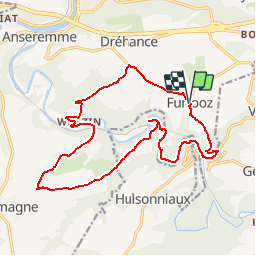
Trail On foot of 16.8 km to be discovered at Wallonia, Namur, Dinant. This trail is proposed by matthias.snoeckx.
Description
Wandeling door bossen, velden en valleien.
Je paseert het kasteel van Wazin, en je volgt ook de Lesse. En mooie en gevarieerde wandeling van 17km.
Positioning
Country:
Belgium
Region :
Wallonia
Department/Province :
Namur
Municipality :
Dinant
Location:
Furfooz
Start:(Dec)
Start:(UTM)
639787 ; 5565274 (31U) N.
Comments
Trails nearby
![Walking Walking](https://static1.geolcdn.com/sitytour/trail-icons/101.png)
RB-Na-24-Entre Lesse et Meuse
Walking
Very difficult
(15)
Dinant,
Wallonia,
Namur,
Belgium
![](/images/other/stat-length.png)
19.3 km | 26 km-effort
5h 57min
![](https://static1.geolcdn.com/siteimages/upload/files/16400158638029165_repeat_loop_refresh_sync_direction_icon.png)
Yes
![Trail Walking Houyet - Nature - The Payenne trail (Houyet) - Photo](https://media.geolcdn.com/t/375/260/ext.jpg?maxdim=2&url=https%3A%2F%2Fservices.sitytrail.com%2FGeolivesWS%2FDownloadMedia.ashx%3FTrailID%3D247221%26Media%3D4a1116e4-3cc3-4f81-a279-87cb261b0cef.jpg)
![Walking Walking](https://static1.geolcdn.com/sitytour/trail-icons/101.png)
Nature - The Payenne trail (Houyet)
Walking
Difficult
(5)
Houyet,
Wallonia,
Namur,
Belgium
![](/images/other/stat-length.png)
14.3 km | 19 km-effort
4h 18min
![](https://static1.geolcdn.com/siteimages/upload/files/16400158638029165_repeat_loop_refresh_sync_direction_icon.png)
Yes
![Trail Walking Houyet - Nature - Royal Park walk - Houyet - Photo](https://media.geolcdn.com/t/375/260/ext.jpg?maxdim=2&url=https%3A%2F%2Fservices.sitytrail.com%2FGeolivesWS%2FDownloadMedia.ashx%3FTrailID%3D193546%26Media%3D0a2a8593-cf69-475f-a9b0-b2a4af4f959b.jpg)
![Walking Walking](https://static1.geolcdn.com/sitytour/trail-icons/101.png)
Nature - Royal Park walk - Houyet
Walking
Difficult
(14)
Houyet,
Wallonia,
Namur,
Belgium
![](/images/other/stat-length.png)
5.7 km | 7.8 km-effort
1h 47min
![](https://static1.geolcdn.com/siteimages/upload/files/16400158638029165_repeat_loop_refresh_sync_direction_icon.png)
Yes
![Trail Walking Houyet - Houyet - Pî-sinte po tortos - Walk for everyone - On foot, by bicycle, on horseback, wheelchair accessible - Photo](https://media.geolcdn.com/t/375/260/ext.jpg?maxdim=2&url=https%3A%2F%2Fservices.sitytrail.com%2FGeolivesWS%2FDownloadMedia.ashx%3FTrailID%3D193539%26Media%3D6b85272b-deee-4a79-9526-05b6bf74491c.jpg)
![Walking Walking](https://static1.geolcdn.com/sitytour/trail-icons/101.png)
Houyet - Pî-sinte po tortos - Walk for everyone - On foot, by bicycle, on ho...
Walking
(6)
Houyet,
Wallonia,
Namur,
Belgium
![](/images/other/stat-length.png)
4.3 km | 4.9 km-effort
1h 0min
![](https://static1.geolcdn.com/siteimages/upload/files/16400158638029165_repeat_loop_refresh_sync_direction_icon.png)
Yes
![Trail Walking Houyet - La Lesse, Natura 2000 - Des sites qui valent le détour, Na07 - Photo](https://media.geolcdn.com/t/375/260/ext.jpg?maxdim=2&url=https%3A%2F%2Fservices.sitytrail.com%2FGeolivesWS%2FDownloadMedia.ashx%3FTrailID%3D188163%26Media%3Df0b29f0e-e19a-4fa8-a869-5ab27b1769d7.JPG)
![Walking Walking](https://static1.geolcdn.com/sitytour/trail-icons/101.png)
La Lesse, Natura 2000 - Des sites qui valent le détour, Na07
Walking
Difficult
(9)
Houyet,
Wallonia,
Namur,
Belgium
![](/images/other/stat-length.png)
8.8 km | 11.5 km-effort
2h 33min
![](https://static1.geolcdn.com/siteimages/upload/files/16400158638029165_repeat_loop_refresh_sync_direction_icon.png)
Yes
![Trail Walking Houyet - RB-Na-05 Hauts lieux de la basse Lesse - Photo](https://media.geolcdn.com/t/375/260/ext.jpg?maxdim=2&url=https%3A%2F%2Fservices.sitytrail.com%2FGeolivesWS%2FDownloadMedia.ashx%3FTrailID%3D179631%26Media%3D95d7547e-2b07-4681-8a2a-4a37901ae9c7.jpg)
![Walking Walking](https://static1.geolcdn.com/sitytour/trail-icons/101.png)
RB-Na-05 Hauts lieux de la basse Lesse
Walking
Medium
(9)
Houyet,
Wallonia,
Namur,
Belgium
![](/images/other/stat-length.png)
24 km | 31 km-effort
6h 33min
![](https://static1.geolcdn.com/siteimages/upload/files/16400158638029165_repeat_loop_refresh_sync_direction_icon.png)
Yes
![Trail Walking Houyet - Nature - Houyet, a royal municipality - Photo](https://media.geolcdn.com/t/375/260/ext.jpg?maxdim=2&url=https%3A%2F%2Fservices.sitytrail.com%2FGeolivesWS%2FDownloadMedia.ashx%3FTrailID%3D166040%26Media%3D0a2a8593-cf69-475f-a9b0-b2a4af4f959b.jpg)
![Walking Walking](https://static1.geolcdn.com/sitytour/trail-icons/101.png)
Nature - Houyet, a royal municipality
Walking
Difficult
(14)
Houyet,
Wallonia,
Namur,
Belgium
![](/images/other/stat-length.png)
8.3 km | 11.5 km-effort
2h 33min
![](https://static1.geolcdn.com/siteimages/upload/files/16400158638029165_repeat_loop_refresh_sync_direction_icon.png)
Yes
![Trail Walking Houyet - RB-Na-05 Raccourci 1 - Hauts lieux de la basse Lesse - Photo](https://media.geolcdn.com/t/375/260/ext.jpg?maxdim=2&url=https%3A%2F%2Fservices.sitytrail.com%2FGeolivesWS%2FDownloadMedia.ashx%3FTrailID%3D213753%26Media%3D8bab1d47-4651-4050-8b88-78bf90d52eb5.jpg)
![Walking Walking](https://static1.geolcdn.com/sitytour/trail-icons/101.png)
RB-Na-05 Raccourci 1 - Hauts lieux de la basse Lesse
Walking
Easy
(5)
Houyet,
Wallonia,
Namur,
Belgium
![](/images/other/stat-length.png)
21 km | 26 km-effort
5h 37min
![](https://static1.geolcdn.com/siteimages/upload/files/16400158638029165_repeat_loop_refresh_sync_direction_icon.png)
Yes
![Trail Walking Houyet - Nature & heritage in Celles, one of the Most Beautiful Villages of Wallonia - Photo](https://media.geolcdn.com/t/375/260/ac9d387c-3f8d-401d-bffe-044b71ce3eff.jpg&format=jpg&maxdim=2)
![Walking Walking](https://static1.geolcdn.com/sitytour/trail-icons/101.png)
Nature & heritage in Celles, one of the Most Beautiful Villages of Wallonia
Walking
Medium
(6)
Houyet,
Wallonia,
Namur,
Belgium
![](/images/other/stat-length.png)
9.6 km | 12.7 km-effort
2h 52min
![](https://static1.geolcdn.com/siteimages/upload/files/16400158638029165_repeat_loop_refresh_sync_direction_icon.png)
Yes