Trail Walking Blaubeuren - Blaubeuren rando  - Photo
 Maca8284
Maca8284

User

© OpenStreetMap contributors
Length
Length
7.3 km
Max alt
Max alt
584 m
Uphill gradient
Uphill gradient
113 m
Km-Effort
Km-Effort  
8.9 km
Min alt
Min alt
498 m
Downhill gradient
Downhill gradient
127 m
Boucle
Boucle
No
Creation date :
2019-11-01 14:31:13.695
Updated on :
2019-11-01 17:39:36.192

(0 Reviews)

Walking
Walking
1h58
Difficulty : Very easy

Scan this QR Code to open this trail in the SityTrail application

FREE GPS app for hiking

Logo SityTrail SityTrail

IGN / Geographical institutes

Download SityTrail from the App Store Download SityTrail from Google Play

Logo SityTrail SityTrail World

The world is yours!

Download SityTrail from the App Store Download SityTrail from Google Play Download SityTrail on Huawei AppGallery

About

Trail Walking of 7.3 km to be discovered at Baden-Württemberg, Alb-Donau-Kreis, Blaubeuren. This trail is proposed by Maca8284.

Description

Super et sous la pluie !

Elevation profile

Positioning

Country:
Germany
Region :
Baden-Württemberg
Department/Province :
Alb-Donau-Kreis
Municipality :
Blaubeuren
Location:
Unknown
Start:(UTM)
559205 ; 5362350 (32U) N.

Trails nearby

Trail On foot Gomadingen - Nebenweg des Schwäbischen Albvereins (rote Gabel) - Photo
On foot
PRO

On foot

Easy
Gomadingen, Baden-Württemberg, Landkreis Reutlingen, Germany
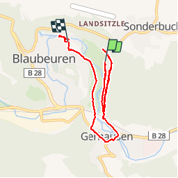
7.7 km | 10.1 km-effort
2h 17min
No
Trail On foot Blaubeuren - Nebenweg des Schwäbischen Albvereins (rote Gabel) - Photo
On foot
PRO

On foot

Easy
Blaubeuren, Baden-Württemberg, Alb-Donau-Kreis, Germany
9.2 km | 13 km-effort
2h 56min
No
Trail On foot Blaubeuren - Nebenweg des Schwäbischen Albvereins (rote Gabel) - Photo
On foot
PRO

On foot

Easy
Blaubeuren, Baden-Württemberg, Alb-Donau-Kreis, Germany
11.2 km | 15.7 km-effort
3h 33min
No


Close
My subscriptions