![](/images/other/stat-length.png)
![Trail Trail Marche-en-Famenne - 20180719140133-WA2K2 - Photo](https://media.geolcdn.com/t/1900/400/ext.pjpeg?maxdim=2&url=https%3A%2F%2Fstatic1.geolcdn.com%2Fsiteimages%2Fupload%2Ffiles%2F1524743154running.jpg)
20180719140133-WA2K2
daniel_2w
User
![Length](/images/other/stat-length.png)
Length
32 km
![Max alt](https://static1.geolcdn.com/siteimages/upload/files/1508320355ic_sort_altitude_max_24dp.png)
Max alt
409 m
![Uphill gradient](https://static1.geolcdn.com/siteimages/upload/files/1508320355ic_sort_den_pos_24dp.png)
Uphill gradient
792 m
![Km-Effort](/images/other/stat-length.png)
Km-Effort
43 km
![Min alt](https://static1.geolcdn.com/siteimages/upload/files/1508320355ic_sort_altitude_min_24dp.png)
Min alt
206 m
![Downhill gradient](https://static1.geolcdn.com/siteimages/upload/files/1508320355ic_sort_den_neg_24dp.png)
Downhill gradient
791 m
![Boucle](https://static1.geolcdn.com/siteimages/upload/files/16400158638029165_repeat_loop_refresh_sync_direction_icon.png)
Boucle
Yes
Creation date :
2019-10-31 20:12:55.171
Updated on :
2020-11-23 12:21:18.854
![Trail](https://static1.geolcdn.com/sitytour/trail-icons/104.png)
--
Difficulty : Difficult
![Scan this QR Code to open this trail in the SityTrail application](https://capi.geolives.com/qq0zvz2zws4bq2lad0pu/sitytour/trails/2254909/qr.png?size=200)
FREE GPS app for hiking
About
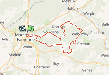
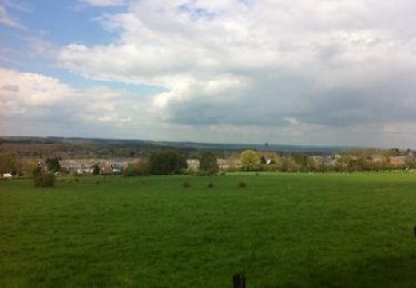
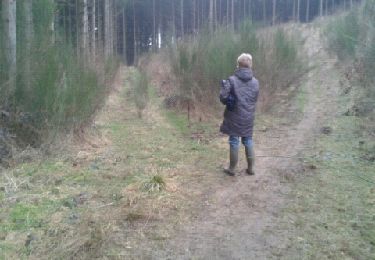
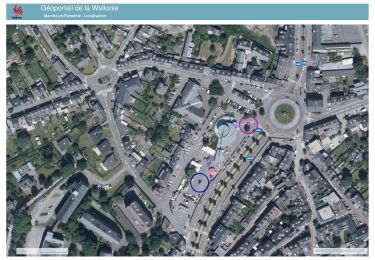
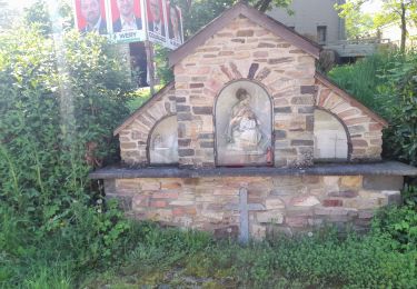
Trail Trail of 32 km to be discovered at Wallonia, Luxembourg, Marche-en-Famenne. This trail is proposed by daniel_2w.
Description
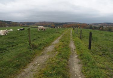
Des chemins parfois techniques vous emmènent vers les villages de Verdenne, Marenne, Menil-Favay, Waharday, Grimbiémont et Champlon-Famenne. Une descente difficile à négocier pour rejoindre Waharday.
Positioning
Country:
Belgium
Region :
Wallonia
Department/Province :
Luxembourg
Municipality :
Marche-en-Famenne
Location:
Marche-en-Famenne
Start:(Dec)
Start:(UTM)
667124 ; 5566738 (31U) N.
Comments
Trails nearby
![Trail On foot Somme-Leuze - Sentiers d'Art : Boucle 17 - Heure - Photo](https://media.geolcdn.com/t/375/260/ext.jpg?maxdim=2&url=https%3A%2F%2Fmedia.geolcdn.com%2Ff%2Fd3b600c0-617d-4b9c-b782-c930c89e279c.jpg)
![On foot On foot](https://static1.geolcdn.com/sitytour/trail-icons/100.png)
Sentiers d'Art : Boucle 17 - Heure
On foot
Medium
(2)
Somme-Leuze,
Wallonia,
Namur,
Belgium
![](/images/other/stat-length.png)
15.9 km | 20 km-effort
4h 33min
![](https://static1.geolcdn.com/siteimages/upload/files/16400158638029165_repeat_loop_refresh_sync_direction_icon.png)
Yes
![Trail Walking Marche-en-Famenne - RB-Lu-31_Marche-en-Famenne - Photo](https://media.geolcdn.com/t/375/260/ext.jpg?maxdim=2&url=https%3A%2F%2Fmedia.geolcdn.com%2Ff%2Fa3476dbc-c577-4b1e-acc4-82c57d99db25.JPG)
![Walking Walking](https://static1.geolcdn.com/sitytour/trail-icons/101.png)
RB-Lu-31_Marche-en-Famenne
Walking
Very easy
(3)
Marche-en-Famenne,
Wallonia,
Luxembourg,
Belgium
![](/images/other/stat-length.png)
24 km | 29 km-effort
6h 10min
![](https://static1.geolcdn.com/siteimages/upload/files/16400158638029165_repeat_loop_refresh_sync_direction_icon.png)
Yes
![Trail Walking Marche-en-Famenne - Walk through the Hedrée valley - Photo](https://media.geolcdn.com/t/375/260/ext.jpg?maxdim=2&url=https%3A%2F%2Fmedia.geolcdn.com%2Ff%2Fab1d5669-7ecf-451e-a04e-4f6f7bcd2b0a.jpg)
![Walking Walking](https://static1.geolcdn.com/sitytour/trail-icons/101.png)
Walk through the Hedrée valley
Walking
Medium
(2)
Marche-en-Famenne,
Wallonia,
Luxembourg,
Belgium
![](/images/other/stat-length.png)
5.7 km | 8.2 km-effort
1h 51min
![](https://static1.geolcdn.com/siteimages/upload/files/16400158638029165_repeat_loop_refresh_sync_direction_icon.png)
Yes
![Trail Walking Marche-en-Famenne - Balade au coeur de Marche - Photo](https://media.geolcdn.com/t/375/260/ext.jpg?maxdim=2&url=https%3A%2F%2Fmedia.geolcdn.com%2Ff%2F15b9b319-2c34-4c39-b3ee-d3f123570689.JPG)
![Walking Walking](https://static1.geolcdn.com/sitytour/trail-icons/101.png)
Balade au coeur de Marche
Walking
Easy
(1)
Marche-en-Famenne,
Wallonia,
Luxembourg,
Belgium
![](/images/other/stat-length.png)
2.8 km | 3.1 km-effort
41min
![](https://static1.geolcdn.com/siteimages/upload/files/16400158638029165_repeat_loop_refresh_sync_direction_icon.png)
Yes
![Trail Walking Marche-en-Famenne - Champlon - Boucle qui alterne sous-bois et vues dégagées à 360°. Larges sentiers caillouteux et un peu de macadam. - Photo](https://media.geolcdn.com/t/375/260/ext.jpg?maxdim=2&url=https%3A%2F%2Fmedia.geolcdn.com%2Ff%2Ff9518a34-3708-4717-a5a9-ec6d14ee87bd.jpg)
![Walking Walking](https://static1.geolcdn.com/sitytour/trail-icons/101.png)
Champlon - Boucle qui alterne sous-bois et vues dégagées à 360°. Larges senti...
Walking
Easy
(1)
Marche-en-Famenne,
Wallonia,
Luxembourg,
Belgium
![](/images/other/stat-length.png)
9.6 km | 12.8 km-effort
2h 23min
![](https://static1.geolcdn.com/siteimages/upload/files/16400158638029165_repeat_loop_refresh_sync_direction_icon.png)
Yes
![Trail Walking Marche-en-Famenne - Aye chapelle + Gerny - Photo](https://media.geolcdn.com/t/375/260/ext.jpg?maxdim=2&url=https%3A%2F%2Fservices.sitytrail.com%2FGeolivesWS%2FDownloadMedia.ashx%3FTrailID%3D122579%26Media%3D20120420144516.jpg)
![Walking Walking](https://static1.geolcdn.com/sitytour/trail-icons/101.png)
Aye chapelle + Gerny
Walking
Easy
(3)
Marche-en-Famenne,
Wallonia,
Luxembourg,
Belgium
![](/images/other/stat-length.png)
6.6 km | 8.1 km-effort
1h 33min
![](https://static1.geolcdn.com/siteimages/upload/files/16400158638029165_repeat_loop_refresh_sync_direction_icon.png)
No
![Trail Walking Marche-en-Famenne - Randoguide - Photo](https://media.geolcdn.com/t/375/260/ext.jpg?maxdim=2&url=https%3A%2F%2Fservices.sitytrail.com%2FGeolivesWS%2FDownloadMedia.ashx%3FTrailID%3D116543%26Media%3D20120310173342.jpeg)
![Walking Walking](https://static1.geolcdn.com/sitytour/trail-icons/101.png)
Randoguide
Walking
Easy
(1)
Marche-en-Famenne,
Wallonia,
Luxembourg,
Belgium
![](/images/other/stat-length.png)
5.2 km | 6.5 km-effort
1h 16min
![](https://static1.geolcdn.com/siteimages/upload/files/16400158638029165_repeat_loop_refresh_sync_direction_icon.png)
Yes
![Trail Walking Marche-en-Famenne - Marche Adeps à Waha - Marche-en-Famenne - Photo](https://media.geolcdn.com/t/375/260/ext.jpg?maxdim=2&url=https%3A%2F%2Fmedia.geolcdn.com%2Ff%2F5c9391b2-99f3-40b9-919c-56cb51638f9c.jpeg)
![Walking Walking](https://static1.geolcdn.com/sitytour/trail-icons/101.png)
Marche Adeps à Waha - Marche-en-Famenne
Walking
Difficult
Marche-en-Famenne,
Wallonia,
Luxembourg,
Belgium
![](/images/other/stat-length.png)
10.4 km | 13.3 km-effort
4h 1min
![](https://static1.geolcdn.com/siteimages/upload/files/16400158638029165_repeat_loop_refresh_sync_direction_icon.png)
Yes
![Trail On foot Marche-en-Famenne - 2. Promenade Pâquerette - Photo](https://media.geolcdn.com/t/375/260/ext.jpg?maxdim=2&url=https%3A%2F%2Fmedia.geolcdn.com%2Ff%2F29b31fe7-992f-4025-89c0-5cc6e93e05df.jpeg)
![On foot On foot](https://static1.geolcdn.com/sitytour/trail-icons/100.png)
2. Promenade Pâquerette
On foot
Easy
Marche-en-Famenne,
Wallonia,
Luxembourg,
Belgium
![](/images/other/stat-length.png)
9.8 km | 11.5 km-effort
2h 36min
![](https://static1.geolcdn.com/siteimages/upload/files/16400158638029165_repeat_loop_refresh_sync_direction_icon.png)
Yes