![](/images/other/stat-length.png)
![Trail Walking Libramont-Chevigny - SityTrail - Entre Lesse et Lomme - Photo](https://media.geolcdn.com/t/1900/400/ext.pjpeg?maxdim=2&url=https%3A%2F%2Fstatic1.geolcdn.com%2Fsiteimages%2Fupload%2Ffiles%2F1553511878bg_sport_marche.png)
SityTrail - Entre Lesse et Lomme
ramagufa
User
![Length](/images/other/stat-length.png)
Length
49 km
![Max alt](https://static1.geolcdn.com/siteimages/upload/files/1508320355ic_sort_altitude_max_24dp.png)
Max alt
554 m
![Uphill gradient](https://static1.geolcdn.com/siteimages/upload/files/1508320355ic_sort_den_pos_24dp.png)
Uphill gradient
805 m
![Km-Effort](/images/other/stat-length.png)
Km-Effort
60 km
![Min alt](https://static1.geolcdn.com/siteimages/upload/files/1508320355ic_sort_altitude_min_24dp.png)
Min alt
150 m
![Downhill gradient](https://static1.geolcdn.com/siteimages/upload/files/1508320355ic_sort_den_neg_24dp.png)
Downhill gradient
1119 m
![Boucle](https://static1.geolcdn.com/siteimages/upload/files/16400158638029165_repeat_loop_refresh_sync_direction_icon.png)
Boucle
No
Creation date :
2019-10-31 15:58:31.278
Updated on :
2021-05-20 17:43:35.227
![Walking](https://static1.geolcdn.com/sitytour/trail-icons/101.png)
22h48
Difficulty : Difficult
![Scan this QR Code to open this trail in the SityTrail application](https://capi.geolives.com/qq0zvz2zws4bq2lad0pu/sitytour/trails/2254685/qr.png?size=200)
FREE GPS app for hiking
About
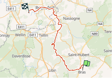
Trail Walking of 49 km to be discovered at Wallonia, Luxembourg, Libramont-Chevigny. This trail is proposed by ramagufa.
Description
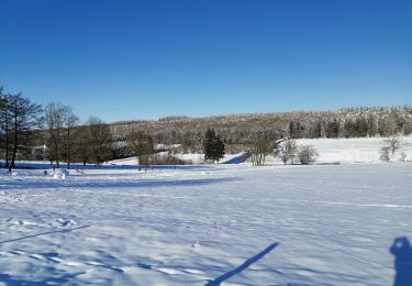
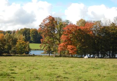
Rando au départ même de la source de la Lomme. (Pas très loin de la chapelle de Lommal)
La première partir du parcours ne se rapproche pas trop d'elle. Il faut compter plus ou moins 10 km avant de pouvoir la longer un peu mieux.
Positioning
Country:
Belgium
Region :
Wallonia
Department/Province :
Luxembourg
Municipality :
Libramont-Chevigny
Location:
Unknown
Start:(Dec)
Start:(UTM)
671375 ; 5539288 (31U) N.
Comments
Trails nearby
![Trail Walking Saint-Hubert - Hatrival - Banalbois (SH13) - Photo](https://media.geolcdn.com/t/375/260/ext.jpg?maxdim=2&url=https%3A%2F%2Fservices.sitytrail.com%2FGeolivesWS%2FDownloadMedia.ashx%3FTrailID%3D334467%26Media%3D16828998-416a-43a0-960f-95ce479e5d6d.jpg)
![Walking Walking](https://static1.geolcdn.com/sitytour/trail-icons/101.png)
Hatrival - Banalbois (SH13)
Walking
Medium
(6)
Saint-Hubert,
Wallonia,
Luxembourg,
Belgium
![](/images/other/stat-length.png)
7.5 km | 9.5 km-effort
2h 2min
![](https://static1.geolcdn.com/siteimages/upload/files/16400158638029165_repeat_loop_refresh_sync_direction_icon.png)
Yes
![Trail Walking Saint-Hubert - Vesqueville - Vesqueville (SH09) - Photo](https://media.geolcdn.com/t/375/260/ext.jpg?maxdim=2&url=https%3A%2F%2Fservices.sitytrail.com%2FGeolivesWS%2FDownloadMedia.ashx%3FTrailID%3D334610%26Media%3D79c980a9-bd48-4f1e-9150-6b805f1400ff.jpg)
![Walking Walking](https://static1.geolcdn.com/sitytour/trail-icons/101.png)
Vesqueville - Vesqueville (SH09)
Walking
Difficult
(6)
Saint-Hubert,
Wallonia,
Luxembourg,
Belgium
![](/images/other/stat-length.png)
15.6 km | 19.4 km-effort
4h 9min
![](https://static1.geolcdn.com/siteimages/upload/files/16400158638029165_repeat_loop_refresh_sync_direction_icon.png)
Yes
![Trail Walking Libramont-Chevigny - Marche ADEPS à Séviscourt. - Photo](https://media.geolcdn.com/t/375/260/a1af7c4b-992e-4843-a6a5-dfa52ee754c1.jpg&format=jpg&maxdim=2)
![Walking Walking](https://static1.geolcdn.com/sitytour/trail-icons/101.png)
Marche ADEPS à Séviscourt.
Walking
Easy
(1)
Libramont-Chevigny,
Wallonia,
Luxembourg,
Belgium
![](/images/other/stat-length.png)
10.3 km | 13.5 km-effort
2h 8min
![](https://static1.geolcdn.com/siteimages/upload/files/16400158638029165_repeat_loop_refresh_sync_direction_icon.png)
Yes
![Trail Walking Saint-Hubert - ADEPS Saint Hubert - Photo](https://media.geolcdn.com/t/375/260/018b420c-08b1-4fdb-919c-55acbcd603df.jpg&format=jpg&maxdim=2)
![Walking Walking](https://static1.geolcdn.com/sitytour/trail-icons/101.png)
ADEPS Saint Hubert
Walking
Difficult
(1)
Saint-Hubert,
Wallonia,
Luxembourg,
Belgium
![](/images/other/stat-length.png)
10.8 km | 13.7 km-effort
1h 57min
![](https://static1.geolcdn.com/siteimages/upload/files/16400158638029165_repeat_loop_refresh_sync_direction_icon.png)
Yes
![Walking Walking](https://static1.geolcdn.com/sitytour/trail-icons/101.png)
RB-Lu-22_Flohimont_via-var
Walking
Very difficult
(1)
Libramont-Chevigny,
Wallonia,
Luxembourg,
Belgium
![](/images/other/stat-length.png)
30 km | 37 km-effort
8h 30min
![](https://static1.geolcdn.com/siteimages/upload/files/16400158638029165_repeat_loop_refresh_sync_direction_icon.png)
Yes
![Walking Walking](https://static1.geolcdn.com/sitytour/trail-icons/101.png)
RB-Lu-22_Flohimont
Walking
Very easy
(1)
Libramont-Chevigny,
Wallonia,
Luxembourg,
Belgium
![](/images/other/stat-length.png)
28 km | 35 km-effort
7h 21min
![](https://static1.geolcdn.com/siteimages/upload/files/16400158638029165_repeat_loop_refresh_sync_direction_icon.png)
Yes
![Trail Walking Saint-Hubert - VESQUEVILLE ... les bois de Sârwé. - Photo](https://media.geolcdn.com/t/375/260/9cdca503-557b-4f6e-8bb6-2c9e1494722a.jpg&format=jpg&maxdim=2)
![Walking Walking](https://static1.geolcdn.com/sitytour/trail-icons/101.png)
VESQUEVILLE ... les bois de Sârwé.
Walking
Easy
(1)
Saint-Hubert,
Wallonia,
Luxembourg,
Belgium
![](/images/other/stat-length.png)
10 km | 12.3 km-effort
2h 27min
![](https://static1.geolcdn.com/siteimages/upload/files/16400158638029165_repeat_loop_refresh_sync_direction_icon.png)
Yes
![Walking Walking](https://static1.geolcdn.com/sitytour/trail-icons/101.png)
RB-Lu-22_Flohimont_via-racc
Walking
Very easy
(1)
Libramont-Chevigny,
Wallonia,
Luxembourg,
Belgium
![](/images/other/stat-length.png)
21 km | 25 km-effort
1h 42min
![](https://static1.geolcdn.com/siteimages/upload/files/16400158638029165_repeat_loop_refresh_sync_direction_icon.png)
Yes
![Trail Walking Saint-Hubert - Hatrival - Hatrival (SH11) - Photo](https://media.geolcdn.com/t/375/260/ext.jpg?maxdim=2&url=https%3A%2F%2Fservices.sitytrail.com%2FGeolivesWS%2FDownloadMedia.ashx%3FTrailID%3D334445%26Media%3D0f06cf58-f0eb-4df9-9750-5fbe487dabd3.jpg)
![Walking Walking](https://static1.geolcdn.com/sitytour/trail-icons/101.png)
Hatrival - Hatrival (SH11)
Walking
Medium
(3)
Saint-Hubert,
Wallonia,
Luxembourg,
Belgium
![](/images/other/stat-length.png)
7.4 km | 9.3 km-effort
1h 59min
![](https://static1.geolcdn.com/siteimages/upload/files/16400158638029165_repeat_loop_refresh_sync_direction_icon.png)
Yes