Trail Walking Le Lindois - La balade du Lindois - Photo

La balade du Lindois

© OpenStreetMap contributors
Length
Length
9.7 km
Max alt
Max alt
294 m
Uphill gradient
Uphill gradient
141 m
Km-Effort
Km-Effort  
11.6 km
Min alt
Min alt
228 m
Downhill gradient
Downhill gradient
141 m
Boucle
Boucle
Yes
Creation date :
2019-10-10 11:55:14.697
Updated on :
2019-10-31 12:51:11.702

(0 Reviews)

Walking
Walking
3h03
Difficulty : Easy

Scan this QR Code to open this trail in the SityTrail application

FREE GPS app for hiking

Logo SityTrail SityTrail

IGN / Geographical institutes

Download SityTrail from the App Store Download SityTrail from Google Play

Logo SityTrail SityTrail World

The world is yours!

Download SityTrail from the App Store Download SityTrail from Google Play Download SityTrail on Huawei AppGallery

About

Trail Walking of 9.7 km to be discovered at New Aquitaine, Charente, Le Lindois. This trail is proposed by alainjoseph6.

Description

Cette randonnée permet de découvrir une région vallonnée avec de nombreux étangs .

Elevation profile

Photos

Positioning

Country:
France
Region :
New Aquitaine
Department/Province :
Charente
Municipality :
Le Lindois
Location:
Unknown
Start:(UTM)
312604 ; 5068686 (31T) N.

Trails nearby

Trail Walking Roussines - Roussines et la vallée de Montizon - Photo
Walking
alainjoseph6

Walking

Easy
Roussines, New Aquitaine, Charente, France
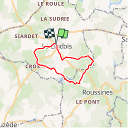
10.7 km | 13.1 km-effort
2h 50min
Yes
Trail Electric bike Massignac - Activity - Photo
Electric bike
KathLala

Electric bike

Very easy
Massignac, New Aquitaine, Charente, France
35 km | 42 km-effort
Unknown
No
Trail Mountain bike Roussines - T02-Roussines à Massignac - Photo
Mountain bike
topolino

Mountain bike

Very easy
Roussines, New Aquitaine, Charente, France
17.4 km | 21 km-effort
Unknown
No


Close
My subscriptions