Trail Walking La Coquille - Sainte-Marie de Frugie 10 km - Photo

Sainte-Marie de Frugie 10 km

 YV24
YV24

User

© OpenStreetMap contributors
Length
Length
9.9 km
Max alt
Max alt
388 m
Uphill gradient
Uphill gradient
191 m
Km-Effort
Km-Effort  
12.4 km
Min alt
Min alt
305 m
Downhill gradient
Downhill gradient
188 m
Boucle
Boucle
Yes
Creation date :
2019-10-29 08:18:14.088
Updated on :
2019-11-03 20:48:27.156

(0 Reviews)

Walking
Walking
2h44
Difficulty : Easy

Scan this QR Code to open this trail in the SityTrail application

FREE GPS app for hiking

Logo SityTrail SityTrail

IGN / Geographical institutes

Download SityTrail from the App Store Download SityTrail from Google Play

Logo SityTrail SityTrail World

The world is yours!

Download SityTrail from the App Store Download SityTrail from Google Play Download SityTrail on Huawei AppGallery

About

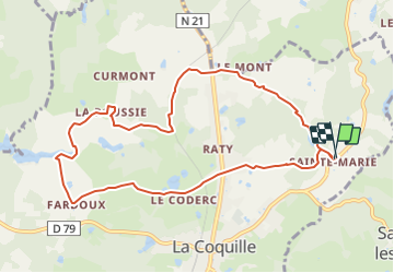
Trail Walking of 9.9 km to be discovered at New Aquitaine, Dordogne, La Coquille. This trail is proposed by YV24.

Description

Variante d'après PDIPR au départ  de la Coquille, mais sans la partie RN21. Bboucle agréable,  variée, praticable en tout temps.
Parking possible sur la petite place au centre du hameau de Ste Marie.
Attention, ce tracé passe par les balisages de plusieurs autres circuits.  Bien suivre ce tracé.

Elevation profile

Positioning

Country:
France
Region :
New Aquitaine
Department/Province :
Dordogne
Municipality :
La Coquille
Location:
Unknown
Start:(UTM)
343586 ; 5046263 (31T) N.

Trails nearby

Trail Walking La Coquille - La Coquille Grateloup 11 km - Photo
Walking
YV24

Walking

Difficult
La Coquille, New Aquitaine, Dordogne, France
11.3 km | 13.9 km-effort
2h 47min
Yes
Trail Walking Saint-Pierre-de-Frugie - St-Pierre de Frugie Ste-Marie La Barde 11 km - Photo
Walking
YV24

Walking

Easy
(3)
Saint-Pierre-de-Frugie, New Aquitaine, Dordogne, France
11.2 km | 14 km-effort
3h 3min
Yes
Trail Walking La Coquille - La Coquille Grateloup 12km - Photo
Walking
YV24

Walking

Easy
La Coquille, New Aquitaine, Dordogne, France
12.2 km | 15 km-effort
3h 14min
Yes
Trail Walking Bussière-Galant - st courbefy - Photo
Walking
Mamidomi

Walking

Difficult
Bussière-Galant, New Aquitaine, Haute-Vienne, France
11.4 km | 15.1 km-effort
3h 25min
Yes
Trail Walking La Coquille - De La Coquille à Thiviers sur Compostelle  - Photo
Walking
000843.e2af63ba812d4dc4a845c93df243350a.2104

Walking

Very difficult
La Coquille, New Aquitaine, Dordogne, France
18.8 km | 22 km-effort
4h 10min
No
Trail Walking Saint-Pierre-de-Frugie - st pierre de frugie - Photo
Walking
Claude GENDRE

Walking

Difficult
Saint-Pierre-de-Frugie, New Aquitaine, Dordogne, France
12.9 km | 15.9 km-effort
3h 10min
Yes
Trail Nordic walking La Coquille - La Coquille à Thiviers - Photo
Nordic walking
BOUMA

Nordic walking

Medium
La Coquille, New Aquitaine, Dordogne, France
19.2 km | 23 km-effort
4h 25min
No
Trail Walking La Coquille - la coquille-chalus - Photo
Walking
pivol

Walking

Medium
La Coquille, New Aquitaine, Dordogne, France
18.9 km | 22 km-effort
6h 5min
No
Trail Walking Bussière-Galant - puy chalard JL 9km 3h samedi - Photo
Walking
PhilMarie

Walking

Medium
Bussière-Galant, New Aquitaine, Haute-Vienne, France
8.6 km | 10.5 km-effort
2h 54min
Yes


Close
My subscriptions