Trail Walking Mazamet - la Passerelle de Mazamet  - Photo

la Passerelle de Mazamet

 nanard31
nanard31

User

© OpenStreetMap contributors
Length
Length
15.4 km
Max alt
Max alt
667 m
Uphill gradient
Uphill gradient
698 m
Km-Effort
Km-Effort  
25 km
Min alt
Min alt
280 m
Downhill gradient
Downhill gradient
697 m
Boucle
Boucle
Yes
Creation date :
2019-10-20 07:41:32.196
Updated on :
2019-10-28 21:05:23.378

(1 Reviews)

Walking
Walking
6h09
Difficulty : Very easy

Scan this QR Code to open this trail in the SityTrail application

FREE GPS app for hiking

Logo SityTrail SityTrail

IGN / Geographical institutes

Download SityTrail from the App Store Download SityTrail from Google Play

Logo SityTrail SityTrail World

The world is yours!

Download SityTrail from the App Store Download SityTrail from Google Play Download SityTrail on Huawei AppGallery

About

Trail Walking of 15.4 km to be discovered at Occitania, Tarn, Mazamet. This trail is proposed by nanard31.

Elevation profile

Positioning

Country:
France
Region :
Occitania
Department/Province :
Tarn
Municipality :
Mazamet
Location:
Unknown
Start:(UTM)
449579 ; 4814510 (31T) N.

Comments

Please log in to post a review or rate the element


Tres belle rando faite le 16 janvier 2022. Petite modification de l'itinéraire. Au niveau du hameau de la Mate, le chemin est maintenant inaccessible, car il passe dans une propriété privée. Il suffit de continuer sur la petite route sur 100m, direvtion Hautpoul, pour rejoindre un sentier qui prend la meme direction. D'apres la propriétaire, la mairie doit faire le nécessaire pour un marquage claire.


Trails nearby

Trail Walking Mazamet - Mazamet - Hautpoul - Photo
Walking
tracegps

Walking

Difficult
(1)
Mazamet, Occitania, Tarn, France
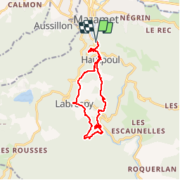
17.4 km | 29 km-effort
6h 30min
Yes
Trail Walking Mazamet - Maeamet la passerelle - Photo
Walking
ombrabella

Walking

Medium
Mazamet, Occitania, Tarn, France
4.5 km | 8.6 km-effort
1h 32min
Yes
Trail Walking Mazamet - Passerelle de Mazamet et village médiéval d'Hautpoul - Photo
Walking
Dominique48

Walking

Difficult
Mazamet, Occitania, Tarn, France
3.2 km | 6.9 km-effort
1h 41min
Yes
Trail Mountain bike Aussillon - Montagne Noire -  Les Montagnès - 6754 - UtagawaVTT.com - Photo
Mountain bike
guillaumepdm

Mountain bike

Difficult
(1)
Aussillon, Occitania, Tarn, France
29 km | 41 km-effort
2h 49min
Yes
Trail Walking Mazamet - depuis HAUPOULet  en 2 boucles - Photo
Walking
chrisgps

Walking

Very easy
Mazamet, Occitania, Tarn, France
14.2 km | 23 km-effort
6h 6min
Yes
Trail Walking Mazamet - Labrespy, Hautpoul, St-Pierre des Plots - Photo
Walking
Jean-Phi81

Walking

Medium
(1)
Mazamet, Occitania, Tarn, France
9 km | 13.8 km-effort
3h 1min
Yes
Trail Walking Mazamet - Labrespy - la Croix de Prat - Photo
Walking
Jean-Phi81

Walking

Medium
(1)
Mazamet, Occitania, Tarn, France
13.8 km | 21 km-effort
4h 35min
Yes
Trail Mountain bike Aiguefonde - Balade sur le Causse - Saint Alby    - Photo
Mountain bike
tracegps

Mountain bike

Medium
Aiguefonde, Occitania, Tarn, France
29 km | 37 km-effort
3h 0min
Yes
Trail Mountain bike Aiguefonde - Les cinq croix - Saint Alby - Photo
Mountain bike
tracegps

Mountain bike

Difficult
Aiguefonde, Occitania, Tarn, France
38 km | 52 km-effort
4h 0min
Yes


Close
My subscriptions