![](/images/other/stat-length.png)
![Trail Walking Saint-Germain-d'Aunay - 2019-10-25 St Germain d'Aunay - Photo](https://media.geolcdn.com/t/1900/400/ext.pjpeg?maxdim=2&url=https%3A%2F%2Fstatic1.geolcdn.com%2Fsiteimages%2Fupload%2Ffiles%2F1553511878bg_sport_marche.png)
2019-10-25 St Germain d'Aunay
BPinglier
User
![Length](/images/other/stat-length.png)
Length
9.3 km
![Max alt](https://static1.geolcdn.com/siteimages/upload/files/1508320355ic_sort_altitude_max_24dp.png)
Max alt
232 m
![Uphill gradient](https://static1.geolcdn.com/siteimages/upload/files/1508320355ic_sort_den_pos_24dp.png)
Uphill gradient
121 m
![Km-Effort](/images/other/stat-length.png)
Km-Effort
10.9 km
![Min alt](https://static1.geolcdn.com/siteimages/upload/files/1508320355ic_sort_altitude_min_24dp.png)
Min alt
186 m
![Downhill gradient](https://static1.geolcdn.com/siteimages/upload/files/1508320355ic_sort_den_neg_24dp.png)
Downhill gradient
123 m
![Boucle](https://static1.geolcdn.com/siteimages/upload/files/16400158638029165_repeat_loop_refresh_sync_direction_icon.png)
Boucle
Yes
Creation date :
2019-10-25 14:28:53.796
Updated on :
2019-10-25 17:19:55.246
![Walking](https://static1.geolcdn.com/sitytour/trail-icons/101.png)
2h06
Difficulty : Very easy
![Scan this QR Code to open this trail in the SityTrail application](https://capi.geolives.com/qq0zvz2zws4bq2lad0pu/sitytour/trails/2249673/qr.png?size=200)
FREE GPS app for hiking
About
Trail Walking of 9.3 km to be discovered at Normandy, Orne, Saint-Germain-d'Aunay. This trail is proposed by BPinglier.
Description
Randonnée facile et assez ombragée sur chemins généralement non balisés. Quelques portions de route goudronnée peu fréquentée. Prévoir de bonnes chaussures.
Parking possible près du monument aux morts.
Positioning
Country:
France
Region :
Normandy
Department/Province :
Orne
Municipality :
Saint-Germain-d'Aunay
Location:
Unknown
Start:(Dec)
Start:(UTM)
307972 ; 5422392 (31U) N.
Comments
Trails nearby
![Trail Walking Sap-en-Auge - Le Sap - Photo](https://media.geolcdn.com/t/375/260/ext.jpg?maxdim=2&url=https%3A%2F%2Fstatic1.geolcdn.com%2Fsiteimages%2Fupload%2Ffiles%2F1553511878bg_sport_marche.png)
![Walking Walking](https://static1.geolcdn.com/sitytour/trail-icons/101.png)
Le Sap
Walking
Very easy
(1)
Sap-en-Auge,
Normandy,
Orne,
France
![](/images/other/stat-length.png)
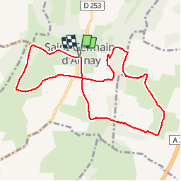
13.5 km | 15.1 km-effort
3h 20min
![](https://static1.geolcdn.com/siteimages/upload/files/16400158638029165_repeat_loop_refresh_sync_direction_icon.png)
Yes
![Trail Walking La Goulafrière - Circuit de la Grande Vallée - La Goulafrière - Photo](https://media.geolcdn.com/t/375/260/ext.jpg?maxdim=2&url=https%3A%2F%2Fservices.sitytrail.com%2FGeolivesWS%2FDownloadMedia.ashx%3FTrailID%3D110461%26Media%3D5968_1.jpg)
![Walking Walking](https://static1.geolcdn.com/sitytour/trail-icons/101.png)
Circuit de la Grande Vallée - La Goulafrière
Walking
Medium
La Goulafrière,
Normandy,
Eure,
France
![](/images/other/stat-length.png)
11.2 km | 13.1 km-effort
2h 45min
![](https://static1.geolcdn.com/siteimages/upload/files/16400158638029165_repeat_loop_refresh_sync_direction_icon.png)
Yes
![Trail Walking La Goulafrière - La Goulafriere 27 - Photo](https://media.geolcdn.com/t/375/260/57bcf86c-5668-45d7-9473-13e9f837b6a9.jpg&format=jpg&maxdim=2)
![Walking Walking](https://static1.geolcdn.com/sitytour/trail-icons/101.png)
La Goulafriere 27
Walking
Easy
La Goulafrière,
Normandy,
Eure,
France
![](/images/other/stat-length.png)
11.9 km | 13.9 km-effort
3h 8min
![](https://static1.geolcdn.com/siteimages/upload/files/16400158638029165_repeat_loop_refresh_sync_direction_icon.png)
Yes
![Trail Walking Sap-en-Auge - Le sap - Photo](https://media.geolcdn.com/t/375/260/ext.jpg?maxdim=2&url=https%3A%2F%2Fstatic1.geolcdn.com%2Fsiteimages%2Fupload%2Ffiles%2F1553511878bg_sport_marche.png)
![Walking Walking](https://static1.geolcdn.com/sitytour/trail-icons/101.png)
![Trail Running La Ferté-en-Ouche - run - Photo](https://media.geolcdn.com/t/375/260/ext.jpg?maxdim=2&url=https%3A%2F%2Fstatic1.geolcdn.com%2Fsiteimages%2Fupload%2Ffiles%2F1524743154running.jpg)
![Running Running](https://static1.geolcdn.com/sitytour/trail-icons/103.png)
![Trail Motorbike La Ferté-en-Ouche - vever - Photo](https://media.geolcdn.com/t/375/260/ext.jpg?maxdim=2&url=https%3A%2F%2Fstatic1.geolcdn.com%2Fsiteimages%2Fupload%2Ffiles%2F1524743155moto.jpg)
![Motorbike Motorbike](https://static1.geolcdn.com/sitytour/trail-icons/402.png)
![Trail Walking La Ferté-en-Ouche - monnai - Photo](https://media.geolcdn.com/t/375/260/ext.jpg?maxdim=2&url=https%3A%2F%2Fstatic1.geolcdn.com%2Fsiteimages%2Fupload%2Ffiles%2F1553511878bg_sport_marche.png)
![Walking Walking](https://static1.geolcdn.com/sitytour/trail-icons/101.png)
monnai
Walking
Difficult
La Ferté-en-Ouche,
Normandy,
Orne,
France
![](/images/other/stat-length.png)
13.2 km | 14.6 km-effort
2h 40min
![](https://static1.geolcdn.com/siteimages/upload/files/16400158638029165_repeat_loop_refresh_sync_direction_icon.png)
Yes
![Trail Motorbike La Ferté-en-Ouche - Simon Yannick - Photo](https://media.geolcdn.com/t/375/260/ext.jpg?maxdim=2&url=https%3A%2F%2Fstatic1.geolcdn.com%2Fsiteimages%2Fupload%2Ffiles%2F1524743155moto.jpg)
![Motorbike Motorbike](https://static1.geolcdn.com/sitytour/trail-icons/402.png)
Simon Yannick
Motorbike
Very easy
La Ferté-en-Ouche,
Normandy,
Orne,
France
![](/images/other/stat-length.png)
18.6 km | 22 km-effort
54min
![](https://static1.geolcdn.com/siteimages/upload/files/16400158638029165_repeat_loop_refresh_sync_direction_icon.png)
No
![Trail Motorbike La Ferté-en-Ouche - Le valet /vimoutiers - Photo](https://media.geolcdn.com/t/375/260/ext.jpg?maxdim=2&url=https%3A%2F%2Fstatic1.geolcdn.com%2Fsiteimages%2Fupload%2Ffiles%2F1524743155moto.jpg)
![Motorbike Motorbike](https://static1.geolcdn.com/sitytour/trail-icons/402.png)
Le valet /vimoutiers
Motorbike
Easy
La Ferté-en-Ouche,
Normandy,
Orne,
France
![](/images/other/stat-length.png)
50 km | 59 km-effort
1h 55min
![](https://static1.geolcdn.com/siteimages/upload/files/16400158638029165_repeat_loop_refresh_sync_direction_icon.png)
No