![](/images/other/stat-length.png)
![Trail Walking Saint-Colomban - Circuit Redour par Pass'Caline - Photo](https://media.geolcdn.com/t/1900/400/ext.pjpeg?maxdim=2&url=https%3A%2F%2Fstatic1.geolcdn.com%2Fsiteimages%2Fupload%2Ffiles%2F1553511878bg_sport_marche.png)
Circuit Redour par Pass'Caline
neoroll44
User
![Length](/images/other/stat-length.png)
![Max alt](https://static1.geolcdn.com/siteimages/upload/files/1508320355ic_sort_altitude_max_24dp.png)
![Uphill gradient](https://static1.geolcdn.com/siteimages/upload/files/1508320355ic_sort_den_pos_24dp.png)
![Km-Effort](/images/other/stat-length.png)
![Min alt](https://static1.geolcdn.com/siteimages/upload/files/1508320355ic_sort_altitude_min_24dp.png)
![Downhill gradient](https://static1.geolcdn.com/siteimages/upload/files/1508320355ic_sort_den_neg_24dp.png)
![Boucle](https://static1.geolcdn.com/siteimages/upload/files/16400158638029165_repeat_loop_refresh_sync_direction_icon.png)
![Walking](https://static1.geolcdn.com/sitytour/trail-icons/101.png)
3h54
Difficulty : Difficult
![Scan this QR Code to open this trail in the SityTrail application](https://capi.geolives.com/qq0zvz2zws4bq2lad0pu/sitytour/trails/2248212/qr.png?size=200)
FREE GPS app for hiking
About
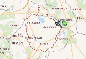
Trail Walking of 16.4 km to be discovered at Pays de la Loire, Loire-Atlantique, Saint-Colomban. This trail is proposed by neoroll44.
Description
Ce grand circuit vous permet de découvrir par des chemins paisibles les paysages du Nord de Saint Colomban et de Geneston, avec des parcours variés : bords de la Gergue et du Redour, chemins creux, hameaux discrets, belles haies. Le parcours s’approche des activités bien implantées sur ce secteur mais parfois méconnues: exploitation de sable, maraîchage et agriculture. Le territoire naturel de Saint Colomban était autrefois couvert de forêts, landes et zones marécageuses. Les noms des villages à proximité de ce circuit, la Lande, la Douve et le Marais Gâté - en perpétuent le souvenir.
Positioning
Comments
Trails nearby
![Trail On foot Montbert - Circuit Passerelle - Photo](https://media.geolcdn.com/t/375/260/942b88c9-86ce-47e9-98c8-b2453147c3a3.jpeg&format=jpg&maxdim=2)
![On foot On foot](https://static1.geolcdn.com/sitytour/trail-icons/100.png)
On foot
![](/images/other/stat-length.png)
![](https://static1.geolcdn.com/siteimages/upload/files/16400158638029165_repeat_loop_refresh_sync_direction_icon.png)
![Trail On foot Montbert - Circuit La Foye - Photo](https://media.geolcdn.com/t/375/260/7457a98f-86c1-4e47-b824-f797a1e41dbe.jpeg&format=jpg&maxdim=2)
![On foot On foot](https://static1.geolcdn.com/sitytour/trail-icons/100.png)
On foot
![](/images/other/stat-length.png)
![](https://static1.geolcdn.com/siteimages/upload/files/16400158638029165_repeat_loop_refresh_sync_direction_icon.png)
![Trail On foot Saint-Colomban - 40 - Photo](https://media.geolcdn.com/t/375/260/c0e725e4-9520-4a9e-8fcf-59fbf8e51811.jpeg&format=jpg&maxdim=2)
![On foot On foot](https://static1.geolcdn.com/sitytour/trail-icons/100.png)
On foot
![](/images/other/stat-length.png)
![](https://static1.geolcdn.com/siteimages/upload/files/16400158638029165_repeat_loop_refresh_sync_direction_icon.png)
![Trail Mountain bike Geneston - Geneston 2022 - Photo](https://media.geolcdn.com/t/375/260/ext.jpg?maxdim=2&url=https%3A%2F%2Fstatic1.geolcdn.com%2Fsiteimages%2Fupload%2Ffiles%2F1524743154velo.jpg)
![Mountain bike Mountain bike](https://static1.geolcdn.com/sitytour/trail-icons/202.png)
Mountain bike
![](/images/other/stat-length.png)
![](https://static1.geolcdn.com/siteimages/upload/files/16400158638029165_repeat_loop_refresh_sync_direction_icon.png)
![Trail On foot Geneston - Circuit des Genêts - Photo](https://media.geolcdn.com/t/375/260/ext.jpg?maxdim=2&url=https%3A%2F%2Fstatic1.geolcdn.com%2Fsiteimages%2Fupload%2Ffiles%2F1545311037marcheuse_200dpi.jpg)
![On foot On foot](https://static1.geolcdn.com/sitytour/trail-icons/100.png)
On foot
![](/images/other/stat-length.png)
![](https://static1.geolcdn.com/siteimages/upload/files/16400158638029165_repeat_loop_refresh_sync_direction_icon.png)
![Trail On foot Geneston - Circuit Blanc - Photo](https://media.geolcdn.com/t/375/260/ext.jpg?maxdim=2&url=https%3A%2F%2Fstatic1.geolcdn.com%2Fsiteimages%2Fupload%2Ffiles%2F1545311037marcheuse_200dpi.jpg)
![On foot On foot](https://static1.geolcdn.com/sitytour/trail-icons/100.png)
On foot
![](/images/other/stat-length.png)
![](https://static1.geolcdn.com/siteimages/upload/files/16400158638029165_repeat_loop_refresh_sync_direction_icon.png)
![Trail On foot Saint-Colomban - La Sorinière - Photo](https://media.geolcdn.com/t/375/260/ext.jpg?maxdim=2&url=https%3A%2F%2Fstatic1.geolcdn.com%2Fsiteimages%2Fupload%2Ffiles%2F1545311037marcheuse_200dpi.jpg)
![On foot On foot](https://static1.geolcdn.com/sitytour/trail-icons/100.png)
On foot
![](/images/other/stat-length.png)
![](https://static1.geolcdn.com/siteimages/upload/files/16400158638029165_repeat_loop_refresh_sync_direction_icon.png)
![Trail Walking Saint-Colomban - Circuit Gergue - Photo](https://media.geolcdn.com/t/375/260/ext.jpg?maxdim=2&url=https%3A%2F%2Fstatic1.geolcdn.com%2Fsiteimages%2Fupload%2Ffiles%2F1553511878bg_sport_marche.png)
![Walking Walking](https://static1.geolcdn.com/sitytour/trail-icons/101.png)
Walking
![](/images/other/stat-length.png)
![](https://static1.geolcdn.com/siteimages/upload/files/16400158638029165_repeat_loop_refresh_sync_direction_icon.png)
![Trail Walking Geneston - Circuit des Genêts - Photo](https://media.geolcdn.com/t/375/260/ext.jpg?maxdim=2&url=https%3A%2F%2Fstatic1.geolcdn.com%2Fsiteimages%2Fupload%2Ffiles%2F1553511878bg_sport_marche.png)
![Walking Walking](https://static1.geolcdn.com/sitytour/trail-icons/101.png)
Walking
![](/images/other/stat-length.png)
![](https://static1.geolcdn.com/siteimages/upload/files/16400158638029165_repeat_loop_refresh_sync_direction_icon.png)
ATTENTION !!! Ce tracé passe le long d'une zone de chasse privée et en activité. J'ai pu le constater lorsque j'ai randonné sur ce circuit le dimanche 14 mai 2023 après-midi. Arrivé sur la portion de circuit prêt du lieu-dit "La Mandironnière" (coordonnée GPS : Latitude = 47.04521° Longitude = -1.57016°) vers 14h15, je vois que le circuit longe une zone de chasse privée. Des panneaux "Chasse en cours" et "Tir à balles" sont fixés sur un arbre. Pas très rassurant lorsqu'on est en randonnée. Une centaine de mètres après être passé devant les panneaux, et en suivant toujours scrupuleusement le tracé, un coup de feu est tiré. Je ne vois pas le chasseur, mais vu le son produit par la détonation, je sais qu'il n'est pas loin (moins de 100 mètres je pense). Je décide donc de rebrousser chemin. Le temps de ressortir de cette zone, 2 autres coups de feu identiques sont tirés. Si comme moi, vous aimez randonner dans une nature calme, je vous déconseille vivement ce tracé.